Martigny-les-Bains

Last updated
Martigny-les-Bains
Blason Martigny-les-Bains.svg
Coat of arms
Location of Martigny-les-Bains
Martigny-les-Bains
France location map-Regions and departements-2016.svg
Red pog.svg
Martigny-les-Bains
Grand Est region location map.svg
Red pog.svg
Martigny-les-Bains
Coordinates: 48°06′23″N5°49′26″E / 48.1064°N 5.8239°E / 48.1064; 5.8239 Coordinates: 48°06′23″N5°49′26″E / 48.1064°N 5.8239°E / 48.1064; 5.8239
Country France
Region Grand Est
Department Vosges
Arrondissement Neufchâteau
Canton Darney
Intercommunality CC Vosges côté Sud-Ouest
Government
  Mayor (20082014) Gérard Sancho
Area
1
29.22 km2 (11.28 sq mi)
Population
 (Jan. 2018) [1]
810
  Density28/km2 (72/sq mi)
Time zone UTC+01:00 (CET)
  Summer (DST) UTC+02:00 (CEST)
INSEE/Postal code
88289 /88320
Elevation342–490 m (1,122–1,608 ft)
(avg. 369 m or 1,211 ft)
1 French Land Register data, which excludes lakes, ponds, glaciers > 1 km2 (0.386 sq mi or 247 acres) and river estuaries.

Martigny-les-Bains is a commune in the Vosges department in Grand Est in northeastern France.

Contents

It acquired its present name only in 1880s, before which it was called Martigny-lès-Lamarche. The modern name highlights the thermal springs and spa facilities which remain a defining feature of the place.

Inhabitants are called Octoduriens.

Geography

Martigny-les-Bains is positioned in the south-west of Grand Est and at the western end of the Vosges Plain, forty kilometres (twenty-five miles) to the south of the administrative centre of the arrondissement, Neufchâteau, approximately six kilometres (four miles) to the north-east of Lamarche, and twenty-two kilometres to the north of another noted spa town, Bourbonne-les-Bains ("Aquae borvonis" in Roman times).

The village occupies a sheltered plateau. On the higher ground forests of oak and beech alternate with conifer plantations. The village is protected by the topography from the worst extremes of wind and temperature.

The railway which since 1881 has provided a connection with Vittel and Contrexéville skirts the village on its north-western side. Some fifteen kilometres to the west the Autoroute A31 offers access to the autoroute network for the age of mass motorisation, while five kilometres to the east, roughly parallel with the autoroute and the railway line, the remnants of a Roman road provide evidence that the district has been much transited over many centuries.

The altitude above sea level at the station is 370 meters, equivalent to 114 meters higher than the valley of the Saône at Les Thons, just fourteen kilometres (nine miles) to the south-south-east. The commune is close to the watershed that separates the catchment areas of the rivers Saône and Meuse. The commune includes within its confines the sources of the Anger and Mouzon rivers which set off in opposite directions before they connect between Pompierre and Circourt after about thirty kilometres (nineteen miles). The valley of the Mouzon, which sets off in a westerly direction before turning to the north, flows over relatively flat plateau land rather than in some form of a gorge: claims appropriate to a spa village are made for the health giving properties of the air here.

History

Following the successive wars against France that characterised the seventeenth century, the village consisted of two parts, namely Martigny-Saint-Remy and Martigny-Saint-Pierre. The nearby village of Saint-Pierre had been destroyed by the Swedes who were in the pay of the French king at this time: the inhabitants turned up as refugees in Martigny-Saint-Remy and constructed the quarter which became known as Martigny-Saint-Pierre, including a church of which the remains survived until recently.

See also

Related Research Articles

Vosges (department) Department of France in Grand Est

Vosges is a department in the Grand Est region in Northeastern France. It covers part of the Vosges mountain range, after which it is named. Vosges consists of 17 cantons and 507 communes, of which 234 are classified as rural, including Domrémy-la-Pucelle, where Joan of Arc was born. In 2017, it had a population of 367,673 with an area of 5,874 km2 ; its prefecture is Épinal.

Neufchâteau, Vosges Subprefecture and commune in Grand Est, France

Neufchâteau is a commune in the Vosges department in Grand Est in northeastern France.

Arrondissement of Neufchâteau, Vosges Arrondissement in Grand Est, France

The arrondissement of Neufchâteau is an arrondissement of France in the Vosges department in the Grand Est region. It has 175 communes. Its population is 53,669 (2016), and its area is 1,817.4 km2 (701.7 sq mi).

Griesheim-près-Molsheim Commune in Grand Est, France

Griesheim-près-Molsheim is a commune in the Bas-Rhin department in Grand Est in north-eastern France.

Montbronn Commune in Grand Est, France

Montbronn is a commune in the Moselle department of the Grand Est administrative region in north-eastern France.

Maconcourt Commune in Grand Est, France

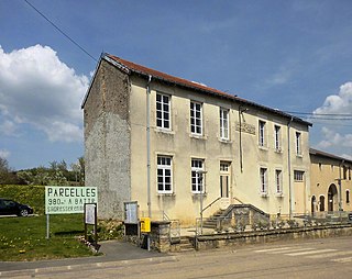
Maconcourt is a commune in the Vosges department in Grand Est in northeastern France.

Martinvelle Commune in Grand Est, France

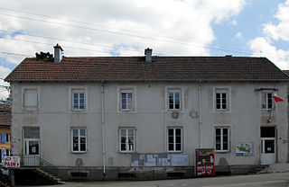
Martinvelle is a commune in the Vosges department in Grand Est in northeastern France.

Mandray Commune in Grand Est, France

Mandray is a commune in the Vosges department in Grand Est in northeastern France.

Mont-lès-Lamarche Commune in Grand Est, France

Mont-lès-Lamarche is a commune in the Vosges department in Grand Est in northeastern France.

Nomexy Commune in Grand Est, France

Nomexy is a commune in the Vosges department in Grand Est in northeastern France.

Norroy Commune in Grand Est, France

Norroy is a commune in the Vosges department in Grand Est in northeastern France.

Pompierre Commune in Grand Est, France

Pompierre is a commune in the Vosges department in Grand Est in northeastern France.

The Canton of Lamarche is a former French administrative and electoral grouping of communes in the Vosges département of eastern France and in the region of Lorraine. It was disbanded following the French canton reorganisation which came into effect in March 2015. It consisted of 26 communes, which joined the canton of Darney in 2015.

The Communauté de communes des Marches de Lorraine is a French former administrative association of rural communes in the Vosges département of eastern France and on the south-western edge of the region of Lorraine. It was merged into the new Communauté de communes les Vosges côté Sud-Ouest in January 2017.

The Canton of Darney is a rural French administrative and electoral grouping of communes in the Vosges département of eastern France and in the region of Grand Est. The Canton of Darney has its administrative centre at Darney.

Vôge Plateau

The Vôge plateau is a sandstone plateau in north east France, straddling the departments of Vosges and Haute-Saône, between Vittel, Saint-Loup-sur-Semouse and Remiremont. It covers approximately 700 km² of Lorraine and Franche-Comté, and includes the towns of Xertigny, Darney, and Bains-les-Bains.

The Maquis des Vosges were groups of French resistance fighters in the Department of the Vosges during the Second World War. They were associated through an amalgamation of different resistance groups roughly when the Conseil national de la Résistance was created on 27 May 1943. Maquis shrubland is a Mediterranean biome of dense scrub, which provided the guerrillas with cover.

Les-bains or Les bains, usually indicating the presence of a spa, may refer to:

The Apance is a river in the East of France. It is one of the main tributaries to the Upper Saône from the Grand Est region. It is 34.4 km (21.4 mi) long.

The Communauté de communes des Vosges côté Sud-Ouest is an administrative association of rural communes in the Vosges department of eastern France. It was created on 1 January 2017 by the merger of the former Communauté de communes des Marches de Lorraine, Communauté de communes du Pays de la Saône Vosgienne, Communauté de communes du Pays de Saône et Madon and the commune Grandrupt-de-Bains. It has its administrative offices at Darney.

References

  1. "Populations légales 2018". INSEE. 28 December 2020.