Mandray

Last updated • 1 min readFrom Wikipedia, The Free Encyclopedia
Mandray
Mandray, Mairie-ecole.jpg
The town hall and school in Mandray
Location of Mandray
Mandray
France location map-Regions and departements-2016.svg
Red pog.svg
Mandray
Grand Est region location map.svg
Red pog.svg
Mandray
Coordinates: 48°13′08″N6°59′47″E / 48.2189°N 6.9964°E / 48.2189; 6.9964
Country France
Region Grand Est
Department Vosges
Arrondissement Saint-Dié-des-Vosges
Canton Saint-Dié-des-Vosges-2
Intercommunality CA Saint-Dié-des-Vosges
Government
  Mayor (20202026) Emmanuel Laurent [1]
Area
1
12.36 km2 (4.77 sq mi)
Population
 (2021) [2]
589
  Density48/km2 (120/sq mi)
Time zone UTC+01:00 (CET)
  Summer (DST) UTC+02:00 (CEST)
INSEE/Postal code
88284 /88650
Elevation398–770 m (1,306–2,526 ft)
(avg. 470 m or 1,540 ft)
1 French Land Register data, which excludes lakes, ponds, glaciers > 1 km2 (0.386 sq mi or 247 acres) and river estuaries.

Mandray (French pronunciation: [mɑ̃dʁɛ] ) is a commune in the Vosges department in Grand Est in northeastern France.

Contents

Inhabitants are called Mandresayens or Mandresayennes in French according to gender.

Geography

Mandray is located some ten kilometres (six miles) southeast of Saint-Dié on the eastern side of the department, and at the western edge of the Vosges Mountains. It nestles in the valley of the Mandresay, a small tributary of the Meurthe which itself rises nearby. The commune is within the Ballons des Vosges Regional Natural Park.

The commune comprises not one single village but rather a grouping of dispersed hamlets at varying altitudes, these being Haute-Mandray, Mi-Mandray, Basse-Mandray, Bénifosse, la Béhouille, la Nold, le Pré du Moulin, Mardichamp, le Raichant (meaning garden in the local patois), les Angles and les Carrières

Using the Mandray Pass, it is possible to drive to Fraize and to La Croix-aux-Mines. Despite a sign indicating an altitude of 707 meters, the actual altitude of the pass is now calculated as 694 meters.

History

Mandray was the scene of fighting early in the First World War. In retaliation, the Germans torched the church on 28 August 1914 and shot some civilians.

See also

Related Research Articles

<span class="mw-page-title-main">Vosges (department)</span> Department of France in Grand Est

Vosges is a department in the Grand Est region, Northeastern France. It covers part of the Vosges mountain range, after which it is named. Vosges consists of three arrondissements, 17 cantons and 507 communes, including Domrémy-la-Pucelle, where Joan of Arc was born. In 2019, it had a population of 364,499 with an area of 5,874 km2 (2,268 sq mi); its prefecture is Épinal.

<span class="mw-page-title-main">Arrondissement of Saint-Dié-des-Vosges</span> Arrondissement in Grand Est, France

The arrondissement of Saint-Dié-des-Vosges is an arrondissement of France in the Vosges department in the Grand Est région. It has 96 communes. Its population is 111,750 (2016), and its area is 1,458.2 km2 (563.0 sq mi).

<span class="mw-page-title-main">Niederentzen</span> Commune in Grand Est, France

Niederentzen is a commune in the Haut-Rhin department in Grand Est in north-eastern France.

<span class="mw-page-title-main">Clérey-la-Côte</span> Commune in Grand Est, France

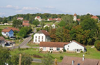
Clérey-la-Côte is a commune in the Vosges department in Grand Est in northeastern France.

<span class="mw-page-title-main">Lalaye</span> Commune in Grand Est, France

Lalaye is a commune in the southwest of the Bas-Rhin department in Grand Est in north-eastern France.

<span class="mw-page-title-main">Danne-et-Quatre-Vents</span> Commune in Grand Est, France

Danne-et-Quatre-Vents is a commune in the Moselle department in Grand Est in north-eastern France.

<span class="mw-page-title-main">Chenebier</span> Commune in Bourgogne-Franche-Comté, France

Chenebier is a commune in the Haute-Saône department in the region of Bourgogne-Franche-Comté in eastern France.

<span class="mw-page-title-main">Basse-sur-le-Rupt</span> Commune in Grand Est, France

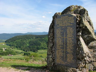
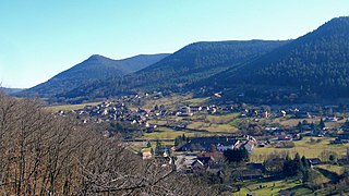
Basse-sur-le-Rupt is a commune in the Vosges department in Grand Est in northeastern France. Its inhabitants are called Bassurois. It is a mountainous commune of seven hamlets, crossed by the river Rupt. Its landmarks include Le Haut du Roc, Le Pierre des Communes, Le Piquante Pierre and the memorial of Le Croix des Moinats. Its historical industries were textiles, sawmills and granite.

Martigny-les-Bains is a commune in the Vosges department in Grand Est in northeastern France.

<span class="mw-page-title-main">Le Ménil</span> Commune in Grand Est, France

Le Ménil is a commune in the Vosges department in Grand Est in northeastern France. It is sometimes called Le Ménil-Thillot to distinguish it from nearby Ménil-de-Senones.

<span class="mw-page-title-main">Moyenmoutier</span> Commune in Grand Est, France

Moyenmoutier is a commune in the Vosges department in Grand Est in northeastern France.

<span class="mw-page-title-main">Le Mont, Vosges</span> Commune in Grand Est, France

Le Mont is a commune in the Vosges department in Grand Est in northeastern France.

<span class="mw-page-title-main">Mont-lès-Lamarche</span> Commune in Grand Est, France

Mont-lès-Lamarche is a commune in the Vosges department in Grand Est in northeastern France.

<span class="mw-page-title-main">Norroy</span> Commune in Grand Est, France

Norroy is a commune in the Vosges department in Grand Est in northeastern France. Inhabitants are called Nogarésiens.

<span class="mw-page-title-main">Pair-et-Grandrupt</span> Commune in Grand Est, France

Pair-et-Grandrupt is a commune in the Vosges department in Grand Est in northeastern France.

<span class="mw-page-title-main">La Petite-Raon</span> Commune in Grand Est, France

La Petite-Raon is a commune in the Vosges department in Grand Est in northeastern France.

<span class="mw-page-title-main">Plainfaing</span> Commune in Grand Est, France

Plainfaing is a commune in the Vosges department in Grand Est in northeastern France.

<span class="mw-page-title-main">Ramonchamp</span> Commune in Grand Est, France

Ramonchamp is a large commune in the Vosges department in Grand Est in northeastern France.

The Canton of Fraize is a French former administrative and electoral grouping of communes in the Vosges département of eastern France and in the region of Lorraine. It was disbanded following the French canton reorganisation which came into effect in March 2015. It had 12,304 inhabitants (2012).

<span class="mw-page-title-main">Canton of Saint-Dié-des-Vosges-2</span> Canton in Grand Est, France

The canton of Saint-Dié-des-Vosges-2 is an administrative division of the Vosges department, in northeastern France. It was created at the French canton reorganisation which came into effect in March 2015. Its seat is in Saint-Dié-des-Vosges.

References

  1. "Répertoire national des élus: les maires" (in French). data.gouv.fr, Plateforme ouverte des données publiques françaises. 13 September 2022.
  2. "Populations légales 2021" (in French). The National Institute of Statistics and Economic Studies. 28 December 2023.