Nayemont-les-Fosses

Last updated
Nayemont-les-Fosses
Nayemont88.jpg
View of Nayemont-les-Fosses, with Saint-Dié-des-Vosges in the background
Blason Nayemont-les-Fosses (88).svg
Coat of arms
Location of Nayemont-les-Fosses
Nayemont-les-Fosses
France location map-Regions and departements-2016.svg
Red pog.svg
Nayemont-les-Fosses
Grand Est region location map.svg
Red pog.svg
Nayemont-les-Fosses
Coordinates: 48°17′51″N7°00′25″E / 48.2975°N 7.0069°E / 48.2975; 7.0069 Coordinates: 48°17′51″N7°00′25″E / 48.2975°N 7.0069°E / 48.2975; 7.0069
Country France
Region Grand Est
Department Vosges
Arrondissement Saint-Dié-des-Vosges
Canton Saint-Dié-des-Vosges-2
Intercommunality CA Saint-Dié-des-Vosges
Government
  Mayor (20202026) Annabelle Soudière
Area
1
8.91 km2 (3.44 sq mi)
Population
 (Jan. 2018) [1]
791
  Density89/km2 (230/sq mi)
Time zone UTC+01:00 (CET)
  Summer (DST) UTC+02:00 (CEST)
INSEE/Postal code
88320 /88100
Elevation345–890 m (1,132–2,920 ft)
(avg. 500 m or 1,600 ft)
1 French Land Register data, which excludes lakes, ponds, glaciers > 1 km2 (0.386 sq mi or 247 acres) and river estuaries.

Nayemont-les-Fosses is a commune in the Vosges department in Grand Est in northeastern France.

Contents

Inhabitants are called Nayemontais.

Geography

The commune is adjacent to Saint-Dié-des-Vosges, on its eastern side, and on the sunny side of the Ormont Hills. The commune's territory extends to the right bank of the little river Fave. The mountain topography enforces a somewhat dispersed layout for the commune's settlements, which include both the village of Nayemont itself and various hamlets such as Brompont, les Basses Fosses, les Hautes Fosses and Menumont.

History

Archaeological discoveries indicate significant human presence here both during the later Neolithic period and subsequently. Presumably the district shared in the switch from a nomadic hunting existence to one involving settlement and agriculture. Presumably, too, the area had its share of fighting and conquest.

During the first millennium, the end of the Gallo-Roman period was accompanied by the disappearance of central authority. It was a troubled period for Lorraine, characterised by wars and the disappearances - presumably following violent assaults - of settled communities. However, the construction on the hill a little to the east of the present day village, of Spitzemberg Castle around 900 indicates an attempt to achieve greater permanence amid the ruins of the Gallo-Roman civilisation. During the Hungarian invasions castles such as this provided a refuge for threatened villagers.

The Lordship of Spitzemberg fell within the Duchy of Lorraine, created in 959 by the German Emperor, Otto I. Lorraine remained subject to the German emperors until the early fifteenth century which ushered in several uncomfortable centuries during which Lorraine would find itself one of several buffer states lodged between the conflicting territorial ambitions of The Empire and of France.

Meanwhile, in the twelfth century the district belonged to the Lords of Paroye until, in 1243, the Dukes of Lorraine themselves acquired the castle, where they installed a garrison: a principal objective of building up and maintaining the castle in this way was the defence of nearby Saint-Dié-des-Vosges to the west. The village o Ayemont (Nayemont) along with the settlements at Les Hautes-Fosses and Les Basse Fosses were part of the domain supporting and dependent of the castle.

The 1550s found the powerful regent Christina, Danish born widow of the former Duke of Lorraine, residing at Spitzemberg Castle. During the time of the dowager duchess Christina, the local inhabitants were granted usage rights to the woods in the lower land around Ayemont which was, at this time, the principal village in the Spitzemberg deanery, with responsibility over the nearby hamlets of Hautes Fosses and Basse Fosses, and under the bailiwick of Saint-Dié. Christina enjoyed her walks and also arranged for the construction and maintenance of a network of forest paths, one of which is still known as "Queen's Path" ("Chemin de la Reine"). The locals were expected to provide some form of military service (guard duty) to the castle, but this could be replaced by a tax in kind, commonly involving rye or oats.

Then as now, the village had no church of its own, being ecclesiastically dependent on the parish of Sainte-Marguerite, a short walk to the south.

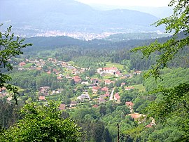
Between 1790 and Year X (1801/02) Ayemont, which by now had become Nayemont, was part of the commune of Bertrimoutier.

See also

Related Research Articles

Raon-lÉtape Commune in Grand Est, France

Raon-l'Étape is a commune in the Vosges Department in Grand Est in northeastern France.

Aranc Commune in Auvergne-Rhône-Alpes, France

Aranc is a commune in the department of Ain in the Auvergne-Rhône-Alpes region of eastern France.

Auxey-Duresses Commune in Bourgogne-Franche-Comté, France

Auxey-Duresses is a commune in the Côte-d'Or department in the Bourgogne-Franche-Comté region of eastern France.

Deycimont Commune in Grand Est, France

Deycimont is a commune in the Vosges department in Grand Est in northeastern France. The residents are known as Rouges-Fournants

Barrême Commune in Provence-Alpes-Côte dAzur, France

Barrême is a commune in the southeastern French department of Alpes-de-Haute-Provence.

Wimmenau Commune in Grand Est, France

Wimmenau is a commune in the Bas-Rhin department in Grand Est in north-eastern France.

Barles Commune in Provence-Alpes-Côte dAzur, France

Barles is a commune in the Alpes-de-Haute-Provence department in the Provence-Alpes-Côte d'Azur region of south-eastern France.

Prads-Haute-Bléone Commune in Provence-Alpes-Côte dAzur, France

Prads-Haute-Bléone is a commune in the Alpes-de-Haute-Provence department and in the Provence-Alpes-Côte d'Azur region in southeastern France.

Thorame-Haute Commune in Provence-Alpes-Côte dAzur, France

Thorame-Haute is a commune in the Alpes-de-Haute-Provence department in southeastern France.

Fouchy Commune in Grand Est, France

Fouchy is a commune in the Bas-Rhin department in Alsace in north-eastern France.

Fouday Commune in Grand Est, France

Fouday is a commune in the Bas-Rhin department in Grand Est in north-eastern France.

Lutzelbourg Commune in Grand Est, France

Lutzelbourg is a commune in the Moselle department in Grand Est in north-eastern France. This town is located in the historic region of Lorraine and is part of the country of Sarrebourg.

Basse-sur-le-Rupt Commune in Grand Est, France

Basse-sur-le-Rupt is a commune in the Vosges department in Grand Est in northeastern France. Its inhabitants are called Bassurois. It is a mountainous commune of seven hamlets, crossed by the river Rupt. Its landmarks include Le Haut du Roc, Le Pierre des Communes, Le Piquante Pierre and the memorial of Le Croix des Moinats. Its historical industries were textiles, sawmills and granite.

Mandray Commune in Grand Est, France

Mandray is a commune in the Vosges department in Grand Est in northeastern France.

Ménil-en-Xaintois Commune in Grand Est, France

Ménil-en-Xaintois is a commune in the Vosges department in Grand Est in northeastern France.

Moyenmoutier Commune in Grand Est, France

Moyenmoutier is a commune in the Vosges department in Grand Est in northeastern France.

Monthureux-sur-Saône Commune in Grand Est, France

Monthureux-sur-Saône is a commune in the Vosges department in Grand Est in northeastern France.

Nonzeville Commune in Grand Est, France

Nonzeville is a commune in the Vosges department in Grand Est in northeastern France.

Pair-et-Grandrupt Commune in Grand Est, France

Pair-et-Grandrupt is a commune in the Vosges department in Grand Est in northeastern France.

Puzieux, Vosges Commune in Grand Est, France

Puzieux is a commune in the Vosges department in Grand Est in northeastern France.

References

  1. "Populations légales 2018". INSEE. 28 December 2020.