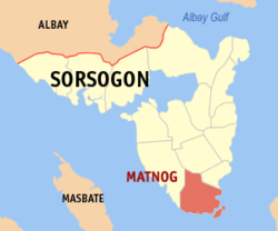
Matnog, officially the Municipality of Matnog (Waray Sorsogon: Bungto san Matnog; Waray: Bungto han Matnog, Tagalog: Bayan ng Matnog), is a municipality in the province of Sorsogon, Philippines and is the southernmost part of Luzon. According to the 2024 census, it has a population of 42,444 people.[5]
The town's port is one of the busiest in the region, playing host to millions of people crossing the San Bernardino Strait to Northern Samar annually. It is the jump off point to Visayas and vice versa.
Etymology
Local elders say that the name Matnog comes from the Bicol word "matonog", which means very audible that describes the loud sound of the waves. Some attribute the name to the sound of the gong used by early chieftains to call council meetings, while others link it to the noise of the tidal rip in the San Bernardino Strait.[6]
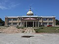
History
Old municipal hall of Matnog, built on the old Presidencia building
In 1785, Matnog became a barrio of Bulusan, with Juan Evangelista serving as its first head. Fifteen years later, it was designated as Puerto Civil. It later became a separate parish on November 21, 1963.[6]
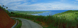
Geography
Mangrove plantation in Mambajog
Matnog is 65 kilometers (40mi) from Sorsogon City and 646 kilometers (401mi) from Manila.
Barangays
Matnog is politically subdivided into 40 barangays. Each barangay consists of puroks and some have sitios.
In order to spur development in the municipality, The Toll Regulatory Board declared Toll Road 5 the extension of South Luzon Expressway.[22] A 420-kilometer (260mi), four-lane expressway starting from the terminal point of the now under construction SLEX Toll Road 4 at Barangay Mayao in Lucena, Quezon, to Matnog, Sorsogon, near the Matnog Ferry Terminal. On August 25, 2020, San Miguel Corporation announced that they will invest the project which will reduce travel time from Lucena to Matnog from 9 hours to 5.5 hours.[23]
Education
The Matnog Schools District Office governs all educational institutions within the municipality. It oversees the management and operations of all private and public, from primary to secondary schools.[24]
This page is based on this Wikipedia article Text is available under the CC BY-SA 4.0 license; additional terms may apply. Images, videos and audio are available under their respective licenses.