Sorsogon Ayta Sorsogon language Central Bikol Tagalog
Prieto Diaz, officially the Municipality of Prieto Diaz, is a municipality in the Philippine province of Sorsogon. According to the 2024 census, it had a population of 23,424 people.[5]
Prieto Diaz got its name from two Bicolano martyrs, Gabriel Prieto and Severino Diaz.[6]
History
The town of Prieto Diaz was once a Visita of the old municipality of Bacon (now Bacon District of Sorsogon City). The town was given its present name from the surnames of the two Bicolano martyrs, Father Gabriel Prieto (1853–1897) and Father Severino Diaz (1862–1897), when it became independent from the municipality of Bacon, on October 12, 1903, by virtue of Act 940 of the Philippine Commission. Prieto Diaz was the only town organized after Sorsogon became a province, on October 17, 1894.[7]
Geography
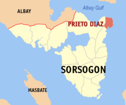
Prieto Diaz is 387km (241mi) southeast of Manila, 150km(31m) east-southeast of Legazpi City, the regional center, and 20km (12.4mi) north-northeast of Sorsogon City, the provincial capital. North of Prieto Diaz, across Albay Gulf, is Rapu-Rapu, in the west is Bacon District of Sorsogon City, and in the south is Gubat, while the Pacific Ocean is on the east. It is also the easternmost point on the island of Luzon.[citation needed]
Barangays
Prieto Diaz is politically subdivided into 23 barangays. Each barangay consists of puroks, and some have sitios.
In 1954, the sitio of Carayat was converted into a barrio.[8]
Prieto Diaz has a tropical climate, with significant rainfall throughout the year, even during the driest month. According to Köppen and Geiger, the climate in Prieto Diaz is classified as Af; the average annual temperature is 27.1°C; and the average annual rainfall is 2965mm. The driest month is April, with 119mm. Most precipitation falls in December, with an average of 514mm. The warmest month of the year is June, with an average temperature of 28.2°C. In January, the average temperature is 25.6°C, the lowest average temperature of the whole year. The difference in precipitation between the driest and wettest months is 395mm. The average temperatures vary during the year by 2.6°C.[10]
Typhoons are especially frequent, and they are destructive menaces in Bicol Region. The months of September, October, and November experience the most destruction. Forty percent of storms carrying high-velocity winds in the Philippines pass through the southeastern part of Luzon, where Prieto Diaz is located.[11]
In 2010, UNESCO released its third volume of Endangered Languages in the World, with three critically endangered languages being in the Philippines. One of these is Southern Ayta (Sorsogon Ayta), which had 150 estimated speakers in 2000. The language was classified as "Critically Endangered", meaning the youngest speakers are grandparents and older, and they speak the language partially and infrequently and hardly pass it to their children and grandchildren.
The Sorsogon Ayta people live only in the municipality of Prieto Diaz; they are one of the original Negrito settlers of the Philippines. They belong to the Aeta people classification but have distinct language and belief systems unique to their own culture and heritage.
The Prieto Diaz school district office governs all educational institutions within the municipality. It oversees the management and operations of all private and public schools, from primary to secondary.[25]
Prieto Diaz had 19 elementary[26] and 4 secondary schools as of 2021[27]
This page is based on this Wikipedia article Text is available under the CC BY-SA 4.0 license; additional terms may apply. Images, videos and audio are available under their respective licenses.