Maudlow, Montana | |
|---|---|
 Maudlow, 2015 | |
 Maudlow  Maudlow | |
| Coordinates: 46°06′28″N111°10′23″W / 46.10778°N 111.17306°W [1] | |
| Country | United States |
| State | Montana |
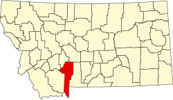
| County | Gallatin |
| Elevation | 4,410 ft (1,340 m) |
| GNIS feature ID | 0786930 [1] |
Maudlow is a small unincorporated community in northern Gallatin County, Montana, United States. [1] The town was a station stop on the transcontinental main line of the Chicago, Milwaukee, St. Paul and Pacific Railroad ("the Milwaukee Road"), and was a community center for a small number of area ranchers and homesteaders. Maudlow was named after a family member of Montana Railroad President R. A. Harlow, Maud Harlow. The first postmaster of the town, George Dodge, shortened the name to Maudlow. [2]
The town is in a narrow valley alongside Sixteen Mile Creek, and near the midpoint of Sixteen Mile Canyon. The canyon, also historically known as "Montana Canyon," was considered a scenic highlight of the Milwaukee Road line.
The population of Maudlow was never large, and by the late 20th century only a handful of residents remained in the area. The railroad through Maudlow was abandoned in 1980, and Maudlow is now nearly a ghost town. It is part of the Bozeman, MT Micropolitan Statistical Area.