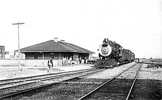
Lewistown is a city in and the county seat of Fergus County, Montana, United States. The population was 5,952 at the 2020 census. Lewistown is located in the geographic center of the state, southeast of Great Falls and northwest of Billings. First planned in 1882, it was the site of an 1880s gold rush, and served as an important railway destination, supplying surrounding communities with bricks via rail.

Harlowton is a city in and the county seat of Wheatland County, Montana, United States. The population was 955 at the 2020 census.

BNSF Railway is the largest freight railroad in the United States. One of six North American Class I railroads, BNSF has 36,000 employees, 33,400 miles (53,800 km) of track in 28 states, and over 8,000 locomotives. It has three transcontinental routes that provide rail connections between the western and eastern United States. BNSF trains traveled over 169 million miles in 2010, more than any other North American railroad.

The Chicago, Milwaukee, St. Paul and Pacific Railroad (CMStP&P), better known as the Milwaukee Road, was a Class I railroad that operated in the Midwest and Northwest of the United States from 1847 until 1986.

The Northern Pacific Railway was a transcontinental railroad that operated across the northern tier of the western United States, from Minnesota to the Pacific Northwest. It was approved by Congress in 1864 and given nearly 40 million acres of land grants, which it used to raise money in Europe for construction.

Sixteen Mile Creek is a 69-mile (111 km) long tributary of the Missouri River in western Montana in the United States. It forms at the confluence of the Middle and South forks of Sixteen Mile Creek, approximately 6 miles (9.7 km) east of Maudlow. The canyon through which it travels is known as "Sixteen Mile Canyon". The abandoned grade of the Chicago, Milwaukee, St. Paul and Pacific Railroad parallels the creek through the canyon; the canyon is referred to as "Montana Canyon" in Milwaukee Road promotional material.

U.S. Route 191 is a spur of U.S. Route 91 that has two segments. The southern segment runs for 1,102 miles (1,773 km) from Douglas, Arizona on the Mexican border to the southern part of Yellowstone National Park. The northern segment runs for 442 miles (711 km) from the northern part of Yellowstone National Park to Loring, Montana, at the Canada–US border. Unnumbered roads within Yellowstone National Park connect the two segments. The highway passes through the states of Arizona, Utah, Wyoming, and Montana.

The North Coast Limited was a named passenger train operated by the Northern Pacific Railway between Chicago and Seattle via Bismarck, North Dakota. It started on April 29, 1900, and continued as a Burlington Northern Railroad train after the merger on March 2, 1970 with Great Northern Railway and the Chicago, Burlington and Quincy Railroad. The next year, it ceased operations after the trains which left their originating stations on April 30, 1971, the day before Amtrak began service, arrived at their destinations.

The Nevada Northern Railway was a railroad in the U.S. state of Nevada, built primarily to reach a major copper producing area in White Pine County, Nevada. The railway, constructed in 1905–06, extended northward about 140 miles (230 km) from Ely to connections with the Western Pacific Railroad at Shafter and Southern Pacific Railroad at Cobre. In 1967 NN reported 40 million net ton-miles of revenue freight on 162 miles (261 km) of line.

The Olympian and its successor the Olympian Hiawatha were passenger trains operated by the Chicago, Milwaukee, St. Paul and Pacific Railroad between Chicago and the Pacific Northwest. The Olympian operated from 1911 to 1947 and was, along with its running mate the Columbian, the first all-steel train to operate in the Pacific Northwest. The streamlined Olympian Hiawatha operated from 1947 to 1961 and was one of several Milwaukee Road trains to carry the name "Hiawatha". The Olympian Hiawatha was designed by industrial designer Brooks Stevens and included the distinctive glassed-in "Skytop" observation-sleeping cars. It later featured full-length "Super Dome" cars.

The Gilmore and Pittsburgh Railroad (G&P), now defunct, was an American railroad located in southwestern Montana and east-central Idaho. Constructed in 1909 and 1910 between Armstead, Montana, and Salmon, Idaho, the G&P served mining and agricultural areas in Lemhi County, Idaho, and Beaverhead County, Montana. The line was financially backed by the Northern Pacific Railway (NP) and later became its subsidiary. Never financially successful, the G&P ceased operations in 1939, and the railroad was dismantled the following year.

The Los Angeles and Salt Lake Railroad was a rail company in California, Nevada, and Utah in the United States, that completed and operated a railway line between its namesake cities, via Las Vegas, Nevada. Incorporated in Utah in 1901 as the San Pedro, Los Angeles and Salt Lake Railroad, the line was largely the brainchild of William Andrews Clark, a Montana mining baron and United States Senator. Clark enlisted the help of Utah's U.S. Senator Thomas Kearns, mining magnate and newspaper man, to ensure the success of the line through Utah. Construction of the railroad's main line was completed in 1905. Company shareholders adopted the LA&SL name in 1916. The railway was also known by its official nickname, "The Salt Lake Route", and was sometimes informally referred to as "The Clark Road". The tracks are still in use by the modern Union Pacific Railroad, as the Cima, Caliente, Sharp, and Lynndyl Subdivisions.
Central Montana Rail, Inc. is a short line railroad operating trackage in Judith Basin, Fergus, and Chouteau Counties, Montana. The company's main line extends approximately 84.2 miles (135.5 km), between the towns of Moccasin and Geraldine; the line connects with the BNSF Railway at Moccasin.

Sixteen is a former unincorporated community in southwestern Meagher County, Montana, United States. The town was a station stop on the transcontinental main line of the Chicago, Milwaukee, St. Paul and Pacific Railroad, and was a community center for a small number of area ranchers and homesteaders. The rail line through Sixteen was originally constructed in 1895 by the Montana Railroad, and the town served as a base camp for railway construction crews.

Maudlow is a small unincorporated community in northern Gallatin County, Montana, United States. The town was a station stop on the transcontinental main line of the Chicago, Milwaukee, St. Paul and Pacific Railroad, and was a community center for a small number of area ranchers and homesteaders. Maudlow was named after a family member of Montana Railroad President R. A. Harlow, Maud Harlow. The first postmaster of the town, George Dodge, shortened the name to Maudlow.

Lombard is a ghost town in southeastern Broadwater County, Montana, United States. The town was located on the east bank of the Missouri River, just north of the mouth of Sixteen Mile Creek.

U.S. Highway 12 (US 12) is an east–west United States Numbered Highway in the state of Montana. It extends approximately 597.576 miles (961.705 km) from the Idaho state line east to the North Dakota state line, the greatest distance that US 12 traverses through any state.

U.S. Highway 191 (US 191) is a north-south United States Numbered Highway in the state of Montana. It extends approximately 442.2 miles (711.7 km) from Yellowstone National Park north to the Canadian border.
The Chehalis Western Railroad was the name of two different shortline railroads that were owned and operated by Weyerhaeuser in Washington state between 1936 and 1993. The first Chehalis Western, which existed from 1936 until 1975, was a shortline Class III railroad, while the second one, which existed from 1981 until 1993, was a private railroad that operated on a different set of lines that Weyerhaeuser had later acquired.

Tower Rock State Park is a state park near the community of Cascade in the U.S. state of Montana in the United States. The centerpiece of the park is Tower Rock, a 424-foot (129 m)-high rock formation which marks the entrance to the Missouri River Canyon in the Adel Mountains Volcanic Field. It was well known to Native Americans, and considered a sacred place by the Piegan Blackfeet. Tower Rock received its current name when Meriwether Lewis of the Lewis and Clark Expedition visited the site in 1805. Railroad and highway development in the late 1800s and 1900s skirted Tower Rock, but the landform itself remained pristine. The 87.2 acres (0.353 km2) encompassing Tower Rock was added to the National Register of Historic Places on March 18, 2002. The 140-acre (0.57 km2) Tower Rock State Park was created around the National Historic Site in 2004.


