
Bird-in-Hand is an unincorporated community and census-designated place (CDP) in Lancaster County, Pennsylvania, United States, in East Lampeter Township. The "Bird in Hand" ZIP code extends east from the CDP into Leacock and Upper Leacock townships. The community has a large Amish and Mennonite population. As of the 2010 census, the population within the CDP was 402.

Park County is a county in the U.S. state of Montana. At the 2020 census, the population was 17,191. Its county seat is Livingston. A small part of Yellowstone National Park is in the southern part of the county.

Gallatin County is located in the U.S. state of Montana. With its county seat in Bozeman, it is the second-most populous county in Montana, with a population of 118,960 in the 2020 Census.

Susitna North is a census-designated place (CDP) in the Matanuska-Susitna Borough in the U.S. state of Alaska. It is part of the Anchorage, Alaska Metropolitan Statistical Area. The population was 1,564 at the 2020 census, up from 1,260 in 2010. The CDP was formerly named Y, for the intersection of the George Parks Highway and the Talkeetna Spur Road. In the immediate vicinity of this intersection is a community center of sorts, containing a health clinic, law enforcement, Susitna Valley High School and retail services for highway travelers such as gasoline and food.

Fort Shaw is a census-designated place (CDP) in Cascade County, Montana, United States. The population was 280 at the 2010 census. Named for a former United States military outpost, it is part of the Great Falls, Montana Metropolitan Statistical Area.

Sun River is a census-designated place (CDP) in Cascade County, Montana, United States. The population was 124 at the 2010 census. It is part of the Great Falls, Montana Metropolitan Statistical Area.

Four Corners is a census-designated place (CDP) in Gallatin County, Montana, United States. The population was 3,146 at the 2010 census, up from 1,828 in 2000. It is part of the Bozeman, MT Micropolitan Statistical Area.

Three Forks is a city in Gallatin County, Montana, United States and is located within the watershed valley system of both the Missouri and Mississippi rivers drainage basins — and is historically considered the birthplace or start of the Missouri River. The population was 1,989 at the 2020 census. The city of Three Forks is named so because it lies geographically near the point, in nearby Missouri Headwaters State Park, where the Jefferson, Madison, and Gallatin Rivers converge to form the Missouri River — the longest single river in North America, as well as the major portion of the Missouri-Mississippi River System from the headwaters near Three Forks to its discharge into the Gulf of Mexico. Three Forks is part of the Bozeman, MT Micropolitan Statistical Area of approximately 100,000 people and located thirty miles west of Bozeman.

Willow Creek is a census-designated place (CDP) in Gallatin County, Montana, United States. The population was 210 at the 2010 census. It is part of the Bozeman, MT Micropolitan Statistical Area.
Augusta is an unincorporated community and census-designated place (CDP) in Lewis and Clark County, Montana, United States. The population was 309 at the 2010 census and rising to 316 in the 2020 census. The most accepted version in the naming of this town is after Augusta Hogan, thought to be the first child born in this town, the daughter of J. D. Hogan, an early rancher.

Avon is a census-designated place (CDP) in Powell County, Montana, United States. The population was 124 at the 2000 census. The town sits along the Little Blackfoot River, and serves as a gateway to the Beaverhead-Deerlodge National Forest.

Harlowton is a city in and the county seat of Wheatland County, Montana, United States. The population was 955 at the 2020 census.

Basin is an unincorporated community and census-designated place (CDP) in Jefferson County, Montana, United States. It lies approximately 10 miles (16 km) southeast of the Continental Divide in a high narrow canyon along Interstate 15 about halfway between Butte and Helena. Basin Creek flows roughly north to south through Basin and enters the Boulder River on the settlement's south side. The population was 212 at the 2010 census, down from 255 at the 2000 census.
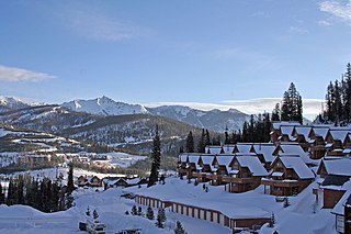
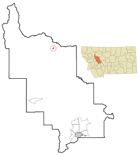
Big Sky is an unincorporated census-designated place (CDP) in Gallatin and Madison counties in southwestern Montana, United States. As of the 2010 census it had a population of 2,308. It is 45 miles (72 km) southwest of Bozeman. This unincorporated community straddles both counties, is not considered a town, and does not have a town government. The primary industry of the area is tourism.
Babb is a small unincorporated farming and ranching community in Glacier County, Montana, United States, on the Blackfeet Indian Reservation. The community experiences a large influx of tourists in the summer months as it is the gateway to the Many Glacier area of Glacier National Park. Babb is a census-designated place (CDP) and had a population of 174 at the 2010 census.

The Gallatin Gateway Inn is a Spanish-stucco style railroad hotel at Gallatin Gateway, Montana. The hotel is one of the "Historic Inns of America." The Gallatin Gateway Inn was opened on June 18, 1927. Constructed and operated by The Milwaukee Road, the luxury hotel was reached by electrified railroad branch line that connected to the Milwaukee's main line at Three Forks, Montana. It was among the first hotels in Montana with telephones in every room, and offered travelers access to Yellowstone National Park. Park buses took passengers from the hotel to the park.
Trego is an unincorporated community, and census-designated place (CDP), in Lincoln County, Montana, United States. As of the 2010 census it had a population of 541. Trego is located 1.5 miles west of Highway 93 and serves as the gateway community to the Tobacco Valley.
Wheatland is a census-designated place (CDP) in Broadwater County, Montana, United States. The population was 568 according to the 2010 census.

Churchill is a census-designated place (CDP) in Gallatin County, Montana, United States. The population was 902 at the 2010 census. It is part of the Bozeman, MT Micropolitan Statistical Area. It was formerly part of the Amsterdam-Churchill CDP.
Bridger is a census-designated place (CDP) in Gallatin County, Montana, United States. It comprises the Bridger Bowl Ski Area and some nearby residences on the eastern side of the Bridger Range in southwestern Montana. As of the 2010 census the Bridger CDP had a population of 30.


