
Saint-Jean-sur-Richelieu is a city in eastern Montérégie in the Canadian province of Quebec, about 40 kilometres (25 mi) southeast of Montreal, located roughly halfway between Montreal and the Canada–United States border with the state of Vermont. It is situated on both the west and east banks of the Richelieu River at the northernmost navigable point of Lake Champlain. As of December 2019, the population of Saint-Jean-sur-Richelieu was 98,036.
Saint-Hyacinthe is a city in southwestern Quebec east of Montreal on the Yamaska River. The population as of the 2021 Canadian census was 57,239. The city is located in Les Maskoutains Regional County Municipality of the Montérégie region, and is traversed by the Yamaska River. Quebec Autoroute 20 runs perpendicular to the river. Saint-Hyacinthe is the seat of the judicial district of the same name.
Blainville is a suburb of Montreal located on the North Shore in southwestern Quebec, Canada. Blainville forms part of the Thérèse-De Blainville Regional County Municipality within the Laurentides region of Quebec. The town sits at the foot of the Laurentian Mountains and is located 35 kilometres (22 mi) northwest of downtown Montreal.

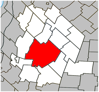
La Vallée-du-Richelieu(The Valley of the Richelieu) is a regional county municipality in the Montérégie region in southwestern Quebec, Canada. Its seat is McMasterville.

Pierre-De Saurel is a regional county municipality in the Montérégie region in southwestern Quebec, Canada. Originally named Le Bas-Richelieu Regional County Municipality, the name change to Pierre-De Saurel took effect on January 1, 2009. Its seat is in Sorel-Tracy. It is located on the Richelieu River, downstream from La Vallée-du-Richelieu Regional County Municipality at the confluence of the Richelieu and Saint Lawrence River.

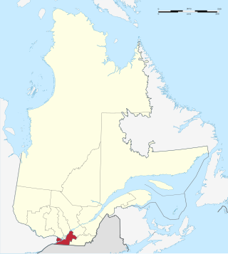
Le Haut-Richelieu Regional County Municipality(Upper Richelieu) is a regional county municipality in the Montérégie region in southwestern Quebec, Canada. Its seat is in Saint-Jean-sur-Richelieu. It is named for the Richelieu River which runs south-north through it.
Saint-Bruno-de-Montarville is an off-island suburb of Montreal, in southwestern Quebec, Canada, on the south bank of the Saint Lawrence River just east of Montreal. It lies on the west flank of Mont Saint-Bruno, one of the Monteregian Hills. The population as of the Canada 2021 Census was 26,273.

Chambly is an off-island suburb of Montreal in southwestern Quebec, Canada. It is located in the Montérégie region, inland from the South Shore of the Saint Lawrence River.

Beloeil is a city in Quebec, Canada. It is a suburb of Montreal, on the South Shore and is on the Richelieu River, 32 kilometres (20 mi) east of Montreal. According to the official Commission de toponymie du Québec, the name is written Belœil with an oe ligature; however, other sources avoid the ligature, including the Ministry of Municipal Affairs and the town's own official website.

Mont-Saint-Hilaire is a suburb of Montreal on the South Shore of southeastern Quebec, Canada, on the Richelieu River in the Regional County Municipality of La Vallée-du-Richelieu. The population as of the Canada 2021 Census was 18,859. The city is named after the Mont Saint-Hilaire.
Montérégie is an administrative region in the southwest part of Quebec. It includes the cities of Boucherville, Brossard, Châteauguay, Longueuil, Saint-Hyacinthe, Saint-Jean-sur-Richelieu, Salaberry-de-Valleyfield and Vaudreuil-Dorion.

Mont Saint-Hilaire is a mountain, 414 m (1,358 ft) high, in the Montérégie region of southern Quebec. It is about thirty kilometres east of Montreal, and immediately east of the Richelieu River. It is one of the Monteregian Hills. Around the mountains are the towns of Mont-Saint-Hilaire and Saint-Jean-Baptiste. Other nearby towns include Otterburn Park, Beloeil and McMasterville.

Otterburn Park is a small town located 40 kilometres (25 mi) east of Montreal, Quebec, Canada. The population as of the Canada 2021 Census was 8,479. The town lies south of Mont-Saint-Hilaire on the Richelieu River and is one of the few officially bilingual towns in Quebec.

The South Shore is the general term for the suburbs of Montreal, Quebec located on the southern shore of the Saint Lawrence River opposite the Island of Montreal. The South Shore is located within the Quebec administrative region of Montérégie.

Saint-Basile-le-Grand is a city located in La Vallée-du-Richelieu Regional County Municipality in southwestern Quebec, Canada. The population as of the 2021 Canadian Census was 17,053.

Saint-Zotique is a city located within the Vaudreuil-Soulanges Regional County Municipality in the Montérégie region located about 45 minutes west of Montreal, Quebec, Canada. It is named for Saint Zoticus of Comana.

Saint-Blaise-sur-Richelieu is a municipality in the Canadian province of Quebec. The population as of the Canada 2016 Census was 2,066. The town was founded in 1892.
Saint-Sébastien is a municipality in Le Haut-Richelieu Regional County Municipality in the Montérégie region of Quebec, Canada. The population as of the Canada 2021 Census was 692.

Saint-Paul-de-l'Île-aux-Noix is a municipality in southern Quebec, Canada located in the administrative area of the Montérégie. The population as of the Canada 2021 Census was 2,141.
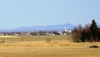
Saint-Jean-Baptiste is a municipality in the Montérégie region of Quebec, a Canadian province. The population as of the Canada 2011 Census was 3,191. It is located within La Vallée-du-Richelieu Regional County Municipality in a valley between Mont Saint-Hilaire and Mont Rougemont.


