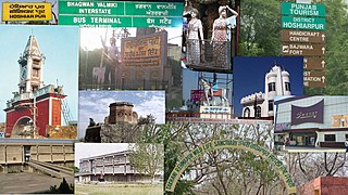
Hoshiarpur is a city and a municipal corporation in Hoshiarpur district in the Doaba region of the Indian state of Punjab. It was founded, according to tradition, during the early part of the fourteenth century. In 1809, it was occupied by the forces of Maharaja Karanvir Singh and was united into the greater state of Punjab in 1849.
Hoshiarpur district is a district of Punjab state in northern India. Hoshiarpur, one of the oldest districts of Punjab, is located in the North-east part of the Punjab state and shares common boundaries with Gurdaspur district in the north-west, Jalandhar district and Kapurthala district in south-west, Kangra district and Una district of Himachal Pradesh in the north-east. Hoshiarpur district comprises 4 sub-divisions, 10 community development blocks, 9 urban local bodies and 1417 villages. The district has an area of 3365 km2. and a population of 1,586,625 persons as per census 2011.

Shaheed Bhagat Singh Nagar district is one of twenty-three districts of state of Punjab, India. It is located in Doaba region. It consists of three subdivisions, Nawanshahr, Banga, and Balachaur. There are three legislative seats in the district, Nawanshahr, Balachaur and Banga. They fall under the Anandpur Sahib Lok Sabha Constituency. Nawanshahr, the district headquarters is about 92 kilometres (57 mi) from Chandigarh, the state's capital.

Doaba, also known as Bist Doab or the Jalandhar Doab, is the region of Punjab, India that lies between the Beas River and the Sutlej River. People of this region are given the demonym "Doabia". The dialect of Punjabi spoken in Doaba is called "Doabi". The term "Doaba" or "Doab" is derived from Persian دو آب meaning "land of two rivers". The river Sutlej separates Doaba from the Malwa region to its south and the river Beas separates Doaba from the Majha region to its north.
Malwa is a geographical region in the south of Punjab state in India. It is located between south of the Sutlej river, north of the Ghaggar river, east of Pakistan, and west of the Sivalik Hills.
Adampur is a town, a municipal council and a sub-tehsil in Jalandhar district in the Indian state of Punjab.
Dasuya (Dasua) is a town and a municipal council in Hoshiarpur district in the state of Punjab, India. It is one of the major subdivisions with 398 villages under its jurisdiction. This town has a great historical and mythological importance.
Garhshankar is a city in Hoshiarpur district in the state of Punjab, India.

Mukerian is a city and municipal corporation of Hoshiarpur district in Punjab, India. Mukerian is located on National Highway 44 and state highway 15 about 450 kilometres (280 mi) north of New Delhi.It is a Sub-district headquarters situated on Jalandhar-jammu railway line and is connected by road with Jalandhar, Hoshiarpur, Talwara, Gurdaspur and Pathankot. National Highway-44 also passes through here.
Talwara is a city, just 58 km from Hoshiarpur city in Hoshiarpur district in the Indian state of Punjab. It is near to the border of the state of Himachal Pradesh.This place is known for proximity to Pong Dam and was mainly populated during the construction of the same. It is situated on the banks of Pong Left Main Canal. locally known as Shah Neher. It consists of 4 sectors and a main market, where people can get there day-to-day needs. Prominent personalities include Mr. Sanjay Choudhary of Datarpur. It is also called Mini Chandigarh for its cleanliness, a rock/rose garden and infrastructure.
Sakruli is a village in Punjab, India.
Bundala, also spelt as Bandala, is a large village in Jalandhar zillah situated in Tehsil Phillaur within the Indian state of Punjab and is located in the centre of the Doaba region of Punjab.
Lakhpur is a village near Sahni (Lakhpur-Sahni), Tehsil Phagwara, Kapurthala district, in Punjab, India.
Odhra also spelled as Odrah is a village in the Dasuya (Dasua) subdivision of the Hoshiarpur district in Punjab, India. Other names for Odhra are Ond, Odhran and Odrysian.
Unchi Bassi is a big village in Hoshiarpur district in the state of Punjab, India. It is just 6 km away from Dasuya city. It is a large base for Military.
Kukanet is a village in Bhunga Block of District Hoshiarpur in Punjab. It is situated in the low hills of Shivalik ranges of the which extends across the whole of northern India. The district headquarter Hoshiarpur is about 40 km away from Kukanet. It is approximately 175 km from Chandigarh. Kukanet is located at the border of Punjab and Himachal Pradesh. The closest town of Himachal Pradesh under District Una is Daulatpur to Kukanet. Nearby villages include Dholbaha (13 km), Baroom(shares the boundary), Bahera(7 km). Although the nearest post office is in Dholbaha, but Kukanet has a branch post office as well. Kukanet's pincode is 144206.
Datarpur is a village situated in Mukerian Tehsil, Hoshiarpur District, Punjab (India). Datarpur State was a small precolonial Indian hill state in the Lower Himalayas. The state was founded around 1550 and was annexed by the Sikh Empire in 1818.
Ajnoha is a village in the Hoshiarpur district of Punjab, India. The village is named after Baba Arjan. Baba Arjan a Rajput warrior founded the village.
Dandoh is a village in the Hoshiarpur tehsil, Hoshiarpur district of Punjab, India. It is one of 415 villages in Hoshiarpur. the closest railway station to Dandoh is Hoshiarpur railway station. The village is situated about 134.5 km from Chandigarh, the state capital.
Lambra Kangri, or more commonly known by the name Lambra is a medium-sized village located in Punjab, India. The post office of Lambra comes under the village of Lambra Kangri or Bulhowal of which bears the pin code of 146113.