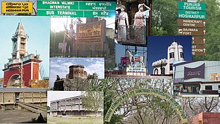
Hoshiarpur is a city and a municipal corporation in Hoshiarpur district in the Doaba region of the Indian state of Punjab. It was founded, according to tradition, during the early part of the fourteenth century. In 1809, it was occupied by the forces of Maharaja Karanvir Singh and was united into the greater state of Punjab in 1849.
Hoshiarpur district is a district of Punjab state in northern India. Hoshiarpur, one of the oldest districts of Punjab, is located in the North-east part of the Punjab state and shares common boundaries with Gurdaspur district in the north-west, Jalandhar district and Kapurthala district in south-west, Kangra district and Una district of Himachal Pradesh in the north-east. Hoshiarpur district comprises 4 sub-divisions, 10 community development blocks, 9 urban local bodies and 1417 villages. The district has an area of 3365 km2. and a population of 1,586,625 persons as per census 2011.

Asni is a village in Maharajganj block of Rae Bareli district, Uttar Pradesh, India. As of 2011, its population is 1,279, in 238 households. It has one primary school and no healthcare facilities. It is located 9 km from Maharajganj, the block headquarters. The main staple foods are wheat and rice.

Dostpur is a village in Bachhrawan block of Rae Bareli district, Uttar Pradesh, India. As of 2011, its population is 1,790, in 315 households. It is located 6 km from Bachhrawan, the block headquarters, and the main staple foods are wheat and rice.

Karangaon is a village in Singhpur block of Amethi district, Uttar Pradesh, India. As of 2011, its population is 3,500, in 601 households.

Khalispur is a village in Bahadurpur block of Rae Bareli district, Uttar Pradesh, India. As of 2011, its population is 3,554, in 607 households. It has one primary school and no healthcare facilities.

Ranmau is a village in Dalmau block of Rae Bareli district, Uttar Pradesh, India. The nearest large town is Lalganj, which is 8 km away. As of 2011, it has a population of 710 people, in 119 households. It has one primary school and no healthcare facilities.

Sarai Manik is a village in Dih block of Rae Bareli district, Uttar Pradesh, India. It is located 23 km from Raebareli, the district headquarters. As of 2011, it has a population of 4,433 people, in 878 households. It has two primary schools. However, the village has no healthcare facilities, permanent market or weekly haat. It belongs to the nyaya panchayat of Dih.

Pratappur is a village in Lalganj block of Rae Bareli district, Uttar Pradesh, India. As of 2011, it has a population of 417 people, in 74 households. It has no schools and no healthcare facilities, and it does not host a permanent market or a weekly haat. It belongs to the nyaya panchayat of Behta Kalan.

Ramaipur Khurd is a village in Sareni block of Rae Bareli district, Uttar Pradesh, India. It is located 16 km from Lalganj, the tehsil headquarters. As of 2011, it has a population of 638 people, in 130 households. It has no schools and no healthcare facilities and does not host a weekly haat or a permanent market. It belongs to the nyaya panchayat of Sagar Khera.

Dandanpur is a village in Khiron block of Rae Bareli district, Uttar Pradesh, India. It is located 20 km from Lalganj, the tehsil headquarters. As of 2011, it has a population of 537 people, in 109 households. It has 1 primary school and no healthcare facilities and it does not host a weekly haat or permanent market. It belongs to the nyaya panchayat of Atarhar.
Legaon is a village in Kishni block of Mainpuri district, Uttar Pradesh, India. As of 2011, it had a total population of 1,427, in 220 households.
Nagla Semar is a village in Sultanganj block of Mainpuri district, Uttar Pradesh. As of 2011, it had a population of 2,256, in 355 households.
Rakri, also spelled Rakari, is a village in Mauganj block of Rewa district, Madhya Pradesh. As of 2011, it had a population of 1,755, in 411 households.
Mahanandpur is a village in Bewar block of Mainpuri district, Uttar Pradesh. As of 2011, it has a population of 944, in 164 households.
Bhagwatipur is a village in Barnahal block of Mainpuri district, Uttar Pradesh. As of 2011, it has a population of 1,087, in 192 households.

Nagla Dal is a village in Tundla block of Firozabad district, Uttar Pradesh, India. As of 2011, it had a population of 2,471, in 383 households.

Mohammadabad is a village in Tundla block of Firozabad district, Uttar Pradesh. As of 2011, it has a population of 8,907, in 1,395 households.

Atipur is a village in Kotla block of Firozabad district, Uttar Pradesh, India. As of 2011, it had a population of 1,339, in 247 households.

Jalalpur is a village in Firozabad block of Firozabad district, Uttar Pradesh, India. Located by the Yamuna river and just off the Agra-Lucknow Expressway, it is the site of a small forest reserve. As of 2011, it had a population of 5,478, in 851 households.
