Mehan, Oklahoma | |
|---|---|
 Mehan  Mehan | |
| Coordinates: 36°2′41″N96°56′33″W / 36.04472°N 96.94250°W | |
| Country | United States |
| State | Oklahoma |
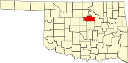
| County | Payne |
| Area | |
• Total | 0.14 sq mi (0.36 km2) |
| • Land | 0.14 sq mi (0.36 km2) |
| • Water | 0 sq mi (0.00 km2) |
| Elevation | 830 ft (250 m) |
| Population (2020) | |
• Total | 34 |
| • Density | 243.5/sq mi (94.03/km2) |
| Time zone | UTC-6 (Central (CST)) |
| • Summer (DST) | UTC-5 (CDT) |
| ZIP Code | 74074 (Stillwater) |
| Area codes | 405/572 |
| FIPS code | 40-47550 |
| GNIS feature ID | 2812866 [2] |
Mehan is an unincorporated community and census-designated place (CDP) in Payne County, Oklahoma, United States. It was first listed as a CDP prior to the 2020 census. [2]
The CDP is in central Payne County, on the northeast side of the valley of Stillwater Creek, a southeast-flowing tributary of the Cimarron River. Mehan is 11 miles (18 km) southeast of Stillwater, the Payne county seat, and 10 miles (16 km) northeast of Perkins.