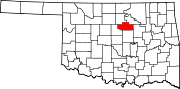
Yale, Oklahoma

Last updated

Yale, Oklahoma
Yale, Oklahoma Water Tower.jpg
Motto: 
" Home Of Jim Thorpe "
Payne County Oklahoma incorporated and unincorporated areas Yale highlighted.svg
Location within Payne County and Oklahoma
Coordinates: 36°06′55″N96°42′04″W / 36.11528°N 96.70111°W / 36.11528; -96.70111
Country United States
State Oklahoma
County Payne
Government
  City Managervacant
Area
[1]
  Total0.92 sq mi (2.37 km2)
  Land0.92 sq mi (2.37 km2)
  Water0.00 sq mi (0.00 km2)
Elevation
[2]
804 ft (245 m)
Population
 (2020)
  Total1,059
  Density1,156.11/sq mi (446.40/km2)
Time zone UTC-6 (CST)
  Summer (DST) UTC-5 (CDT)
ZIP code
74085
Area code 539/918
FIPS code 40-82500 [3]
GNIS feature ID2412315 [2]

Yale is a city in Payne County, Oklahoma, United States. The population was 1,059 at the 2020 census, a decline of 13.6 percent from the figure of 1,227 in 2010. [4]

Contents

History

Historic Yale (1909) Yale main 1909.jpg
Historic Yale (1909)

Yale's founding in 1895 is attributed to a local farmer, Sterling F. Underwood, who established a post office by that name in his general store, about 1.5 miles (2.4 km) east of the present town. When the Eastern Oklahoma Railway built its line across Payne County, a group led by George W. Canfield began a different townsite also within Eagle Township that would be closer to the railroad, at its planned junction with the Missouri–Kansas–Texas Railroad. Underwood moved his store to the new site in 1902, making the new site the permanent location for the town of Yale. A 1907 map shows the town contained 230 acres surrounding the railroad junction, and to its east southeast the Underwood farm of 158 acres. [5] By 1910, Yale had a population of 685, supported mostly by agricultural services and cotton processing. [6]

On September 23, 1913, an oil well on the Randle farm produced a gusher. An even larger gusher began producing a month later. More discoveries followed. By the end of 1914, the combined Yale and Cushing fields were producing 220,000 barrels a day. The town boomed, attaining a population of 2,601 by the census of 1920. [6]

The oil boom quickly deflated. Production began to decline sharply in 1915, and more dry holes were reported. Major producers began to shut down or reduce operations in the early 1920s. By 1930, the population had dropped to 1,734. In 1940, the census reported a population of 1,407. The decline continued until reaching a low of 1,239 in 1970. There was a spike by 1980, when the census recorded 1,652, but the downward trend resumed through 2010. Town officials have tried to stem the decline by promoting Yale as a retirement location. [6]

Geography

Yale is 20 miles (32 km) east of Stillwater on State Highway 51. [6] According to the United States Census Bureau, the city has a total area of 0.9 square miles (2.3 km2), all land.

The primary source of Yale's water supply is Lone Chimney Lake. The lake's level has been declining for several years because of prolonged drought conditions and high water consumption of water by Yale and other Oklahoma towns that rely on this lake as their primary source. [7]

Demographics

Historical population
CensusPop.Note
1910 685
1920 2,601279.7%
1930 1,734−33.3%
1940 1,407−18.9%
1950 1,359−3.4%
1960 1,3690.7%
1970 1,239−9.5%
1980 1,65233.3%
1990 1,392−15.7%
2000 1,342−3.6%
2010 1,227−8.6%
2020 1,059−13.7%
U.S. Decennial Census [8]

As of the census of 2010, there were 1,227 people living in the city. [9] The population density was 1,473.3 inhabitants per square mile (568.8/km2). There were 604 housing units at an average density of 670 per square mile (260/km2). [9] The racial makeup of the city was 87.63% White, 6.93% Native American, 0.30% Asian, 0.15% from other races, and 4.99% from two or more races. Hispanic or Latino of any race were 0.98% of the population.

There were 529 households, out of which 32.1% had children under the age of 18 living with them, 51.0% were married couples living together, 10.6% had a female householder with no husband present, and 32.1% were non-families. 30.2% of all households were made up of individuals, and 14.6% had someone living alone who was 65 years of age or older. The average household size was 2.47 and the average family size was 3.04.

In the city, the population was spread out, with 26.7% under the age of 18, 10.3% from 18 to 24, 25.6% from 25 to 44, 20.0% from 45 to 64, and 17.5% who were 65 years of age or older. The median age was 36 years. For every 100 females, there were 91.2 males. For every 100 females age 18 and over, there were 88.1 males.

The median income for a household in the city was $23,403, and the median income for a family was $30,714. Males had a median income of $26,630 versus $15,813 for females. The per capita income for the city was $11,346. About 15.7% of families and 19.5% of the population were below the poverty line, including 22.3% of those under age 18 and 13.5% of those age 65 or over.

Government

Yale had a city manager form of government. [6]

Notable people

Related Research Articles

<span class="mw-page-title-main">Creek County, Oklahoma</span> County in Oklahoma, United States

Creek County is a county located in the U.S. state of Oklahoma. As of the 2020 census, the population was 71,754. Its county seat is Sapulpa.

<span class="mw-page-title-main">Underwood, Iowa</span> City in Iowa, United States

Underwood is a town in Pottawattamie County, Iowa, United States. The population was 954 at the time of the 2020 census.

<span class="mw-page-title-main">Underwood, North Dakota</span> City in North Dakota, United States

Underwood is a city in McLean County, North Dakota, United States. The population was 784 at the 2020 census.

<span class="mw-page-title-main">Watts, Oklahoma</span> Town in Oklahoma, United States

Watts is a town in northern Adair County, Oklahoma, United States. It was named for John Watts, also known as Young Tassel, a Chickamauga Cherokee chief, who died in 1802. The population was 324 at the 2010 census, an increase of 2.5 percent over the figure of 316 recorded in 2000.

<span class="mw-page-title-main">Union City, Oklahoma</span> Town in Oklahoma, United States

Union City is a town in Canadian County, Oklahoma, United States. The population was 1,645 at the 2010 census, a 19.6 percent increase from 1,375 in 2000. It is part of the Oklahoma City metropolitan statistical area.

<span class="mw-page-title-main">Wilson, Oklahoma</span> Town in Oklahoma, United States

Wilson is a town in Carter County, Oklahoma, United States. The population was 1,724 at the 2010 census. It is part of the Ardmore, Oklahoma Micropolitan Statistical Area. It is home to one of the oldest Assemblies of God churches in Oklahoma, the Wilson Assembly of God Church.

<span class="mw-page-title-main">Oilton, Oklahoma</span> City in Oklahoma, United States

Oilton is a city in Creek County, Oklahoma, United States. The population was 885 at the 2020 census, a 12.6% decline from the 1,013 recorded in 2010.

<span class="mw-page-title-main">Howe, Oklahoma</span> Town in Oklahoma, United States

Howe is a town in Le Flore County, Oklahoma, United States. It is part of the Fort Smith, Arkansas-Oklahoma Metropolitan Statistical Area. The population was 802 at the 2010 census, a gain of 15.1 percent over the figure of 697 recorded in 2000. The town was once noted for producing coal and coke, but today is chiefly supported by agriculture.

<span class="mw-page-title-main">Fallis, Oklahoma</span> Town in Lincoln County, Oklahoma, United States

Fallis is a town in Lincoln County, Oklahoma, United States. The population was 27 at the 2010 census, a decline of 3.6 percent from the figure of 28 in 2000.

<span class="mw-page-title-main">Sparks, Oklahoma</span> Town in Oklahoma, United States

Sparks is a town in Lincoln County, Oklahoma, United States. The population was 169 at the 2010 census, a 23.4 percent gain from the figure of 137 in 2000. The center of population of Oklahoma is located in Sparks.

Meridian is a town in eastern Logan County, Oklahoma, United States. The population was 38 at the 2010 census, a decline of 29.5 percent from the figure of 54 in 2000. It is part of the Oklahoma City Metropolitan Statistical Area. The community name was chosen because of its location on the Indian meridian.

<span class="mw-page-title-main">Mulhall, Oklahoma</span> Town in Oklahoma, United States

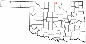
Mulhall is a town in Logan (mostly) and Payne counties in Oklahoma, United States. The population was 225 at the 2010 census, down 5.9 percent from the figure of 239 in 2000. It is part of the Oklahoma City Metropolitan Statistical Area.

<span class="mw-page-title-main">Weleetka, Oklahoma</span> Town in Oklahoma, United States

Weleetka is a town in Okfuskee County, Oklahoma, United States. It is approximately 10 miles (16 km) southeast of Okemah, the county seat. The name is a Creek word meaning "running water." The population was 806 at the time of the 2020 census.

<span class="mw-page-title-main">Lake Aluma, Oklahoma</span> Town in Oklahoma, United States

Lake Aluma is a town in Oklahoma County, Oklahoma, United States, and a part of the Oklahoma City Metropolitan Area. The population was 88 at the 2010 census.

<span class="mw-page-title-main">Ripley, Oklahoma</span> Town in Oklahoma, United States

Ripley is a town in southeastern Payne County, Oklahoma, United States. The population was 423 at the 2010 census, a decline of 9.2 percent from the figure of 444 in 2000. The town was named after Edward Ripley, the 14th president of the Atchison, Topeka and Santa Fe Railway.

<span class="mw-page-title-main">Earlsboro, Oklahoma</span> Town in Oklahoma, United States

Earlsboro is a town in Pottawatomie County, Oklahoma, United States. The population was 628 at the 2010 census, a decline of 0.8 percent from the figure of 633 in 2000. It was once called "...the town that whisky built and oil broke."

<span class="mw-page-title-main">Paradise Hill, Oklahoma</span> Town in Oklahoma, United States

Paradise Hill is a town in the northwest corner of Sequoyah County, Oklahoma, United States. It is part of the Fort Smith, Arkansas-Oklahoma Metropolitan Statistical Area. The population was 85 at the 2010 census, a decline from the figure of 100 recorded in 2000.

<span class="mw-page-title-main">Little Beaver Township, Lawrence County, Pennsylvania</span> Township in Pennsylvania, United States

Little Beaver Township is a township in Lawrence County, Pennsylvania, United States. The population was 1,227 at the time of the 2020 census, a decline from the figure of 1,411 tabulated in 2010.

<span class="mw-page-title-main">Geary, Oklahoma</span> City in Oklahoma, United States

Geary is a city in Blaine and Canadian counties in the U.S. state of Oklahoma. The population was 994 at the 2020 census. The town was named for Edmund Guerrier, a scout and an interpreter for the U.S. Army.

<span class="mw-page-title-main">Fair Oaks, Oklahoma</span> Town in Oklahoma, United States

Fair Oaks is a town in Rogers and Wagoner counties in the U.S. state of Oklahoma. The population was 103 at the 2010 census, a 15.6 percent decline from the figure of 122 recorded in 2000. It is a suburb of Tulsa.

References

  1. "ArcGIS REST Services Directory". United States Census Bureau. Retrieved September 20, 2022.
  2. 1 2 U.S. Geological Survey Geographic Names Information System: Yale, Oklahoma
  3. "U.S. Census website". United States Census Bureau . Retrieved January 31, 2008.
  4. CensusViewer:Population of the City of Yale, Oklahoma. Accessed March 29, 2012
  5. 1907 Map of Eagle Township, Payne County, Oklahoma, accessed December 2017 (via ancestry.com paid subscription site).
  6. 1 2 3 4 5 D. Earl Newsom, "Yale," Encyclopedia of Oklahoma History and Culture. Accessed March 30, 2012.
  7. "Yale struggles with water shortage." The Journal Record (archive). March 25, 2013. Accessed September 6, 2015.
  8. "Census of Population and Housing". Census.gov. Retrieved June 4, 2015.
  9. 1 2 "2010 City Population and Housing Occupancy Status". U.S. Census Bureau. Retrieved October 18, 2013.[ dead link ]