Meisburg

Last updated
Meisburg
Wappen Meisburg.gif
Coat of arms
Germany adm location map.svg
Red pog.svg
Meisburg
Location of Meisburg within Vulkaneifel district
Meisburg in DAU.svg
Coordinates: 50°06′38″N6°41′32″E / 50.11056°N 6.69222°E / 50.11056; 6.69222 Coordinates: 50°06′38″N6°41′32″E / 50.11056°N 6.69222°E / 50.11056; 6.69222
Country Germany
State Rhineland-Palatinate
District Vulkaneifel
Municipal assoc. Daun
Government
   Mayor Dieter Klein
Area
  Total 7.05 km2 (2.72 sq mi)
Elevation 475 m (1,558 ft)
Population (2015-12-31) [1]
  Total 243
  Density 34/km2 (89/sq mi)
Time zone CET/CEST (UTC+1/+2)
Postal codes 54570
Dialling codes 06599
Vehicle registration DAU
Website www.meisburg.de

Meisburg (in Eifel dialect: Mesbuasch) is an Ortsgemeinde – a municipality belonging to a Verbandsgemeinde , a kind of collective municipality – in the Vulkaneifel district in Rhineland-Palatinate, Germany. It belongs to the Verbandsgemeinde of Daun, whose seat is in the like-named town. In Meisburg, a Moselle Franconian dialect is spoken.

Municipalities of Germany the lowest official level of territorial division in Germany

Municipalities are the lowest level of official territorial division in Germany. This is most commonly the third level of territorial division, ranking after the Land (state) and Kreis (district). The Gemeinde which is one level lower in those states also includes Regierungsbezirke as an intermediate territorial division. The Gemeinde is one level higher if it is not part of a Samtgemeinde. Only 10 municipalities in Germany have fifth level administrative subdivisions and all of them are in Bavaria. The highest degree of autonomy may be found in the Gemeinden which are not part of a Kreis. These Gemeinden are referred to as Kreisfreie Städte or Stadtkreise, sometimes translated as having "city status". This can be the case even for small municipalities. However, many smaller municipalities have lost this city status in various administrative reforms in the last 40 years when they were incorporated into a Kreis. In some states they retained a higher measure of autonomy than the other municipalities of the Kreis. Municipalities titled Stadt are urban municipalities while those titled Gemeinde are classified as rural municipalities.

A Verbandsgemeinde is a low-level administrative unit in the German federal states of Rhineland-Palatinate and Saxony-Anhalt. A Verbandsgemeinde is typically composed of a small group of villages or towns.

Vulkaneifel is a district (Kreis) in the northwest of the state Rhineland-Palatinate, Germany. It is the least densely populated district in the state and the fourth most sparsely populated district in Germany. The administrative centre of the district is in Daun. Neighboring districts are Euskirchen, Ahrweiler, Mayen-Koblenz, Cochem-Zell, Bernkastel-Wittlich, and Bitburg-Prüm.

Contents

Geography

Location

The municipality lies on Bundesstraße 257 between Daun (19 km) and Bitburg (24 km) in the middle of the Vulkaneifel, a part of the Eifel known for its volcanic history, geographical and geological features, and even ongoing activity today, including gases that sometimes well up from the earth.

<i>Bundesstraße</i> denotation for German and Austrian national highways

Bundesstraße, abbreviated B, is the denotation for German and Austrian national highways.

Daun, Germany Place in Rhineland-Palatinate, Germany

Daun is a town in the Vulkaneifel district in Rhineland-Palatinate, Germany. It is the district seat and also the seat of the Verbandsgemeinde of Daun.

Bitburg Place in Rhineland-Palatinate, Germany

Bitburg is a city in Germany, in the state of Rhineland-Palatinate approximately 25 km (16 mi.) northwest of Trier and 50 km (31 mi.) northeast of Luxembourg city. The American Spangdahlem Air Base is nearby.

The German Volcano Route, which opened in September 2006, runs past the village.

German Volcano Route 280 km touristic route from the river Rhine to the upper Eifel-mountains region along vocanic features of the Eifel.

The German Volcano Route or, less commonly, German Volcano Road is a 280-kilometre-long tourist route from the River Rhine to the mountains of the High Eifel. It links 39 sites within the Geopark Vulkanland Eifel in the Volcanic Eifel (Vulkaneifel), at which geological, cultural-historical and industrial-historical nature and cultural monuments on the subject of volcanicity in the Eifel are located.

The village sits in the valley of the Dümpelbach at a mean elevation of 480 m above sea level. The highest elevations in the area are the Daxelberg at 589 m above sea level and Rackenbach at 522 m above sea level. The Schafbach, which empties into the Lohsalm, rises in the Salmwald (forest), a water-rich area with a waterworks. From here, great parts of the Bernkastel-Wittlich district are supplied with drinking water.

Sea level Average level for the surface of the ocean at any given geographical position on the planetary surface

Mean sea level (MSL) is an average level of the surface of one or more of Earth's oceans from which heights such as elevation may be measured. MSL is a type of vertical datum – a standardised geodetic datum – that is used, for example, as a chart datum in cartography and marine navigation, or, in aviation, as the standard sea level at which atmospheric pressure is measured to calibrate altitude and, consequently, aircraft flight levels. A common and relatively straightforward mean sea-level standard is the midpoint between a mean low and mean high tide at a particular location.

Bernkastel-Wittlich is a district in Rhineland-Palatinate, Germany. It is bounded by the districts of Vulkaneifel, Cochem-Zell, Rhein-Hunsrück, Birkenfeld, Trier-Saarburg and Bitburg-Prüm.

Meisburg from the north Panorama meisburg 2.jpg
Meisburg from the north
Meisburg from the south Panorama meisburg.jpg
Meisburg from the south

Neighbouring municipalities

All the following are Meisburg’s immediate neighbours:

History

The Eifel’s settlement history gives clues as to when the village of Meisburg might have arisen. Finds from the New Stone Age from about 4500 to 1800 BC and clues to Roman settlement about AD 300 in what is now Meisburg’s municipal area bear witness to human habitation here quite early on. The municipality owns a collection of Stone-Age stone hatchets, blades, scraping tools and arrowheads.

Eifel low mountain range in Germany

The Eifel is a low mountain range in western Germany and eastern Belgium. It occupies parts of southwestern North Rhine-Westphalia, northwestern Rhineland-Palatinate and the south of the German-speaking Community of Belgium.

Ancient Rome History of Rome from the 8th-century BC to the 5th-century

In historiography, ancient Rome is Roman civilization from the founding of the Italian city of Rome in the 8th century BC to the collapse of the Western Roman Empire in the 5th century AD, encompassing the Roman Kingdom, Roman Republic and Roman Empire until the fall of the western empire. The civilization began as an Italic settlement in the Italian Peninsula, conventionally founded in 753 BC, that grew into the city of Rome and which subsequently gave its name to the empire over which it ruled and to the widespread civilisation the empire developed. The Roman Empire expanded to become one of the largest empires in the ancient world, though still ruled from the city, with an estimated 50 to 90 million inhabitants and covering 5.0 million square kilometres at its height in AD 117.

Following the Celts were the Romans. The Roman road known as the Weinstraße (“Wine Road”) also came through the Meisburg area, running from Kirn in the Hunsrück by way of Wittlich, and then on the Rackenbacher Wies’chen (a “little meadow”) past nearby Meisburg to Prüm and Malmedy. The Rheinisches Landesmuseum Trier has confirmed an ancient settlement in the rural cadastral area “In der Delt” from the 2nd and 3rd centuries, presumably a Roman farm.

Celts ethnolinguistic group of tribal societies in Iron Age and Medieval Europe

The Celts are an Indo-European ethnolinguistic group of Europe identified by their use of Celtic languages and cultural similarities. The history of pre-Celtic Europe and the exact relationship between ethnic, linguistic and cultural factors in the Celtic world remains uncertain and controversial. The exact geographic spread of the ancient Celts is disputed; in particular, the ways in which the Iron Age inhabitants of Great Britain and Ireland should be regarded as Celts have become a subject of controversy. According to one theory, the common root of the Celtic languages, the Proto-Celtic language, arose in the Late Bronze Age Urnfield culture of Central Europe, which flourished from around 1200 BC.

Roman roads roads built in service of the Roman Empire

Roman roads were physical infrastructure vital to the maintenance and development of the Roman state, and were built from about 300 BC through the expansion and consolidation of the Roman Republic and the Roman Empire. They provided efficient means for the overland movement of armies, officials, and civilians, and the inland carriage of official communications and trade goods. Roman roads were of several kinds, ranging from small local roads to broad, long-distance highways built to connect cities, major towns and military bases. These major roads were often stone-paved and metaled, cambered for drainage, and were flanked by footpaths, bridleways and drainage ditches. They were laid along accurately surveyed courses, and some were cut through hills, or conducted over rivers and ravines on bridgework. Sections could be supported over marshy ground on rafted or piled foundations.

Kirn Place in Rhineland-Palatinate, Germany

Kirn is a town in the Bad Kreuznach district in Rheinland-Pfalz, Germany. It does not lie within any Verbandsgemeinde, even though it is the seat of the Verbandsgemeinde of Kirn-Land. Kirn is a middle centre serving an area on the Nahe and in the Hunsrück.

The Romans were driven out by Germanic tribes, and later in the course of the Migration Period came the Franks. In Meisburg, a Moselle Franconian dialect is still spoken today.

Although the municipality marked 750 years of existence in 1979, but it is quite a bit older than that. Meisburg was first mentioned (as “Meisbreth”) in a document of Pope Innocent II in 1140 as property of the abbey Saint Maximin in Trier. The village probably existed around 1116, when the monks of Saint Maximin forged several charters, wherein Meisburg is mentioned as “Meisbrath”.

In 1229 Theoderich and his wife Clarissa, the Lord and Lady of Bruch, donated the patronage and two shares of the tithes at Meisburg to Saint Thomas’s Monastery. In 1330, a church was already listed in the village and Meisburg belonged to the Electoral-Trier Amt of Kyllburg. Saint Thomas’s Monastery was in the centuries that followed Meisburg’s landholder.

When an end was put to the monastery’s landholding rights in 1794, the Amt of Kyllburg also ceased to be in force as the lands on the Rhine’s left bank were annexed by France. Under Napoleonic rule, Meisburg belonged to the Department of Sarre, and more locally to the canton of Prüm. At the Congress of Vienna in 1814 and 1815, this area was assigned to Prussia. The district of Daun was formed and Meisburg belonged to the Bürgermeisterei (“Mayoralty”) of Weidenbach, later being reassigned to the Bürgermeisterei of Niederstadtfeld. Since 1947, it has been part of the then newly founded state of Rhineland-Palatinate, and the former administration in Niederstadtfeld was absorbed into the Verbandsgemeinde of Daun.

The centralized water supply came to the village in 1920, and electricity in 1924. The provincial road, now known as Bundesstraße 257, between Daun and Kyllburg was built in the 1930s.

There is one ghost village near Meisburg, named Rackenbach, and there is also a vanished village, which was called Bradscheid.

As early as 1522, a mill was mentioned. The sawmill on the river Lohsalm is the only working, water-driven sawmill left in the Rhineland. About 2 km up the dale, the remnants of a further mill together with a millrace may still be found.

The Schafbrück, today a hotel, already existed in the 19th century. In the early 1950s, three outlying farms were established at Rackenbach and three more at Rascheid; all are still going concerns.

A school was first mentioned in Meisburg in 1721. This was closed in the course of school reform in 1978. The Wallenborn primary school and the Niederstadtfeld Hauptschule are now the schools for the municipality. A Gymnasium and a Realschule are to be found in Daun and Gerolstein. The former school building in Meisburg now houses the kindergarten for Deudesfeld, Meisburg, Wallenborn and Weidenbach. [2]

Politics

Municipal council

The council is made up of 6 council members, who were elected at the municipal election held on 7 June 2009, and the honorary mayor as chairman.

Mayor

Meisburg’s mayor is Dieter Klein, and his deputies are Johannes Görgen and Berthold Rieker.

Coat of arms

The German blazon reads: Von silber über schwarz geteilt, oben das kurtrierische Kreuz, unten ein rot-silber geschachtelter Schrägrechtsbalken.

The municipality’s arms might in English heraldic language be described thus: Per fess argent a cross gules and sable a bend countercompony of the first and second.

The cross above the line of partition is Electoral Trier’s old armorial bearing and represents Meisburg’s allegiance to Trier in feudal times. The bend countercompony (that is, slanted stripe chequered in two rows) is the charge borne by the Cistercians. This stands for the village’s former landholder, Saint Thomas’s Monastery, which held Meisburg from 1229 to 1794. [3]

Town partnerships

Meisburg fosters partnerships with the following places:

Schoppen is a village within the municipality of Amel (or Amblève in French), and it lies in Belgium’s eastern German-speaking region. [4]

Culture and sightseeing

Meisburg has an old sawmill, which is driven by an overshot waterwheel seven metres in diameter. The Schneidemühle (“cutting mill”), as it is known locally, is the Rhineland’s, and the Eifel’s, last preserved sawmill. The energy needed to drive it is afforded by a 350 m-long millpond.

Notable structures in Meisburg include the following:

Economy and infrastructure

A significant portion of the local economy derives from the local American Spangdahlem Air Base.

Related Research Articles

Kelberg Place in Rhineland-Palatinate, Germany

Kelberg is an Ortsgemeinde – a municipality belonging to a Verbandsgemeinde, a kind of collective municipality – in the Vulkaneifel district in Rhineland-Palatinate, Germany. It belongs to the like-named Verbandsgemeinde, and is home to its seat. Kelberg is a state-recognized climatic spa.

Lutzerath Place in Rhineland-Palatinate, Germany

Lutzerath is an Ortsgemeinde – a municipality belonging to a Verbandsgemeinde, a kind of collective municipality – in the Cochem-Zell district in Rhineland-Palatinate, Germany. It belongs to the Verbandsgemeinde of Ulmen, whose seat is in the like-named town. Lutzerath is a recognized recreational resort (Erholungsort).

Daun (Verbandsgemeinde) Place in Rhineland-Palatinate, Germany

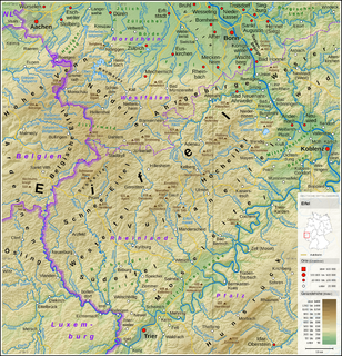
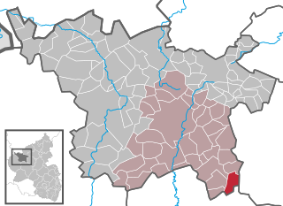
Daun is a collective municipality (Verbandsgemeinde) in the Vulkaneifel district of Rhineland-Palatinate, Germany. The seat of the Daun Verbandsgemeinde is in the municipality of Daun.

Basberg Place in Rhineland-Palatinate, Germany

Basberg is an Ortsgemeinde – a municipality belonging to a Verbandsgemeinde, a kind of collective municipality – in the Vulkaneifel district in Rhineland-Palatinate, Germany. It belongs to the Verbandsgemeinde of Gerolstein, whose seat is in the like-named town.

Bleckhausen Place in Rhineland-Palatinate, Germany

Bleckhausen is an Ortsgemeinde – a municipality belonging to a Verbandsgemeinde, a kind of collective municipality – in the Vulkaneifel district in Rhineland-Palatinate, Germany. It belongs to the Verbandsgemeinde of Daun, whose seat is in the like-named town.

Boxberg, Rhineland-Palatinate Place in Rhineland-Palatinate, Germany

Boxberg is an Ortsgemeinde – a municipality belonging to a Verbandsgemeinde, a kind of collective municipality – in the Vulkaneifel district in Rhineland-Palatinate, Germany. It belongs to the Verbandsgemeinde of Kelberg, whose seat is in the like-named municipality.

Kirchweiler Place in Rhineland-Palatinate, Germany

Kirchweiler is an Ortsgemeinde – a municipality belonging to a Verbandsgemeinde, a kind of collective municipality – in the Vulkaneifel district in Rhineland-Palatinate, Germany. It belongs to the Verbandsgemeinde of Daun, whose seat is in the like-named town.

Kradenbach Place in Rhineland-Palatinate, Germany

Kradenbach is an Ortsgemeinde – a municipality belonging to a Verbandsgemeinde, a kind of collective municipality – in the Vulkaneifel district in Rhineland-Palatinate, Germany. It belongs to the Verbandsgemeinde of Daun, whose seat is in the like-named town.

Niederstadtfeld Place in Rhineland-Palatinate, Germany

Niederstadtfeld is an Ortsgemeinde – a municipality belonging to a Verbandsgemeinde, a kind of collective municipality – in the Vulkaneifel district in Rhineland-Palatinate, Germany. It belongs to the Verbandsgemeinde of Daun, whose seat is in the like-named town.

Oberbettingen Place in Rhineland-Palatinate, Germany

Oberbettingen is an Ortsgemeinde – a municipality belonging to a Verbandsgemeinde, a kind of collective municipality – in the Vulkaneifel district in Rhineland-Palatinate, Germany. It belongs to the Verbandsgemeinde of Gerolstein, whose seat is in the like-named town.

Oberstadtfeld Place in Rhineland-Palatinate, Germany

Oberstadtfeld is an Ortsgemeinde – a municipality belonging to a Verbandsgemeinde, a kind of collective municipality – in the Vulkaneifel district in Rhineland-Palatinate, Germany. It belongs to the Verbandsgemeinde of Daun, whose seat is in the like-named town.

Rockeskyll Place in Rhineland-Palatinate, Germany

Rockeskyll is an Ortsgemeinde – a municipality belonging to a Verbandsgemeinde, a kind of collective municipality – in the Vulkaneifel district in Rhineland-Palatinate, Germany. It belongs to the Verbandsgemeinde of Gerolstein, whose seat is in the like-named town.

Sarmersbach Place in Rhineland-Palatinate, Germany

Sarmersbach is an Ortsgemeinde – a municipality belonging to a Verbandsgemeinde, a kind of collective municipality – in the Vulkaneifel district in Rhineland-Palatinate, Germany. It belongs to the Verbandsgemeinde of Daun, whose seat is in the like-named town.

Schutz, Germany Place in Rhineland-Palatinate, Germany

Schutz is an Ortsgemeinde – a municipality belonging to a Verbandsgemeinde, a kind of collective municipality – in the Vulkaneifel district in Rhineland-Palatinate, Germany. It belongs to the Verbandsgemeinde of Daun, whose seat is in the like-named town.

Strotzbüsch Place in Rhineland-Palatinate, Germany

Strotzbüsch is an Ortsgemeinde – a municipality belonging to a Verbandsgemeinde, a kind of collective municipality – in the Vulkaneifel district in Rhineland-Palatinate, Germany. It belongs to the Verbandsgemeinde of Daun, whose seat is in the like-named town.

Üdersdorf Place in Rhineland-Palatinate, Germany

Üdersdorf is an Ortsgemeinde – a municipality belonging to a Verbandsgemeinde, a kind of collective municipality – in the Vulkaneifel district in Rhineland-Palatinate, Germany. It belongs to the Verbandsgemeinde of Daun, whose seat is in the like-named town.

Udler Place in Rhineland-Palatinate, Germany

Udler is an Ortsgemeinde – a municipality belonging to a Verbandsgemeinde, a kind of collective municipality – in the Vulkaneifel district in Rhineland-Palatinate, Germany. It belongs to the Verbandsgemeinde of Daun, whose seat is in the like-named town.

Wallenborn Place in Rhineland-Palatinate, Germany

Wallenborn is an Ortsgemeinde – a municipality belonging to a Verbandsgemeinde, a kind of collective municipality – in the Vulkaneifel district in Rhineland-Palatinate, Germany. It belongs to the Verbandsgemeinde of Daun, whose seat is in the like-named town. The municipality is a state-recognized tourism community (Fremdenverkehrsgemeinde).

Weidenbach, Vulkaneifel Place in Rhineland-Palatinate, Germany

Weidenbach is an Ortsgemeinde – a municipality belonging to a Verbandsgemeinde, a kind of collective municipality – in the Vulkaneifel district in Rhineland-Palatinate, Germany. It belongs to the Verbandsgemeinde of Daun, whose seat is in the like-named town. In Weidenbach, a Moselle Franconian dialect is spoken.

Welcherath Place in Rhineland-Palatinate, Germany

Welcherath is an Ortsgemeinde – a municipality belonging to a Verbandsgemeinde, a kind of collective municipality – in the Vulkaneifel district in Rhineland-Palatinate, Germany. It belongs to the Verbandsgemeinde of Kelberg, whose seat is in the like-named municipality.

References