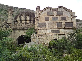
Waziristan is a mountainous region of Pakistani province of Khyber Pakhtunkhwa. The Waziristan region administratively splits among three districts: North Waziristan, Lower South Waziristan District, and Upper South Waziristan District. Waziristan region, consisted of three districts, covers around 11,585 square kilometres (4,500 sq mi) and is mainly populated by the Mehsud, The Wolves, & Wazir Pashtun tribe, who speak the Waziri dialect of the Pashto language.

North Waziristan District is a district of Khyber Pakhtunkhwa province in Pakistan. It is the northern part of Waziristan, a mountainous region of northwest Pakistan, bordering Afghanistan and covering 4,707 square kilometres (1,817 sq mi). The capital city of North Waziristan is Miranshah.

Orakzai District is a district in the Kohat Division of the Khyber Pakhtunkhwa province of Pakistan. Before 1973, it was part of FR Kohat. Up until 2018, it was an agency within the erstwhile Federally Administered Tribal Areas. However, with the merger of the FATA with Khyber Pakhtunkhwa, it attained the status of a district.

South Waziristan District was a district in the Dera Ismail Khan Division of the Khyber Pakhtunkhwa province of Pakistan, before splitting into the Lower South Waziristan District and the Upper South Waziristan District on 13 April 2022. It covers around 11,585 km2 (4,473 mi2). Waziristan is located in the southwest of Khyber Pakhtunkhwa. It is situated between two rivers, the Tochi River to the north and the Gomal River to the south. The region was an independent tribal territory from 1893, separated from both Afghanistan and the British-ruled empire in the subcontinent. Raiding the tribal areas was a constant problem for the British, requiring frequent punitive expeditions between 1860 and 1945. Troops of the British Raj coined a name for this region "Hell's Door Knocker" in recognition of the fearsome reputation of the local fighters and inhospitable terrain. The district headquarter of the South Waziristan district is Wanna. South Waziristan is divided into three administrative subdivisions of Ladha, Sarwakai, and Wanna. These three subdivisions are further divided into eight Tehsils: Ladha, Makin, Sararogha, Sarwakai, Tiarza, Wanna, Barmal, and Toi Khula.

Khyber District is a district in the Peshawar Division of the Khyber Pakhtunkhwa province of Pakistan. Until 2018, it was an agency of the erstwhile Federally Administered Tribal Areas. With the merger of FATA with Khyber Pakhtunkhwa in 2018, it became a district. It ranges from the Tirah valley down to Peshawar. It borders Nangarhar Province to the west, Orakzai District to the south, Kurram District to southwest, Peshawar to the east and Mohmand District to the north.

Kohat Division is one of the seven divisions in the Khyber Pakhtunkhwa province of Pakistan. It consists of five districts: Hangu, Karak, Kohat, Kurram, and Orakzai. The division borders Bannu Division to the south and west, Peshawar Division to the north and east, the province of Punjab to the east, and Afghanistan to the northwest. CNIC code of Kohat Division is 14.

Bannu Division is one of seven divisions in Pakistan's Khyber Pakhtunkhwa province. It consists of three districts: Bannu, Lakki Marwat, and North Waziristan. The division borders Dera Ismail Khan Division to the south and west, Kohat Division to the north and east, and the province of Punjab, Pakistan to its east. CNIC code of Bannu Division is 11.

Dera Ismail Khan Division is an administrative division of Khyber Pakhtunkhwa Province, Pakistan. It is the southernmost division of Khyber Pakhtunkhwa. CNIC code of Dera Ismail Khan Division is 12.

Bettani Tehsil is an administrative subdivision (tehsil) of Lakki Marwat District in Khyber Pakhtunkhwa province of Pakistan. This subdivision shares its boundary on the north with Bannu Subdivision, on the west with Jandola Tehsil, to the west with North and South Waziristan and to the northeast with the district of Lakki Marwat. Its total area is 132 square kilometers.

The Federally Administered Tribal Areas, commonly known as FATA, was a semi-autonomous tribal region in north-western Pakistan that existed from 1947 until being merged with the neighbouring province of Khyber Pakhtunkhwa in 2018 through the Twenty-fifth amendment to the constitution of Pakistan. It consisted of seven tribal agencies (districts) and six frontier regions, and were directly governed by the federal government through a special set of laws called the Frontier Crimes Regulations.
The Chamkani, is a sub-tribe of Ghoryakhel Pashtuns. According to Muhammad Hayat Khan, author of Hayat-i-Afghani Chamkani are descendants of Ibrahim Ghoria. They are also related to Mohmand, Daudzai and Khalil through their Sarbani descent.

Jandola Tehsil is an administrative subdivision (tehsil) of Tank District in Khyber Pakhtunkhwa province of Pakistan. The subdivision borders South Waziristan to the north, south and west and Lakki Marwat District to the north-east.

There are many types of gemstones of Pakistan. They can be found among the nation's three mountain ranges - the Hindu Kush, the Himalayas, and the Karakoram - in the provinces of Khyber Pakhtunkhwa, Gilgit-Baltistan, Balochistan, and the Federally Administered Tribal Areas. The gemstone industry in Pakistan has the city of Peshawar as its hub, and there are many companies working in it.
Administrative System of FATA was the system by which semi-autonomous tribal region of Federally Administered Tribal Areas was governed.

Barang Tehsil is an administrative subdivision (tehsil) of Bajaur District in Khyber Pakhtunkhwa, Pakistan. Barang is the sixth largest of Bajaur District's seven tehsils.

Mamund Tehsil is an administrative subdivision (tehsil) of Bajaur District in Khyber Pakhtunkhwa Province, Pakistan. Mamund is the largest of Bajaur District's seven tehsils.
Terrorist incidents in Pakistan in 2018 include:

The Twenty-fifth Amendment to the Constitution of Pakistan was passed by the Parliament of Pakistan and the Khyber Pakhtunkhwa Assembly in May 2018. Under the amendment, the Federally Administered Tribal Areas (FATA) and Provincially Administered Tribal Areas (PATA) are to be merged with the province of Khyber Pakhtunkhwa (KP).
The Khasadar were paramilitary forces operating throughout the Federally Administered Tribal Areas (FATA), now a part of Khyber Pakhtunkhwa province in Pakistan. The Khasadar were a locally recruited and maintained tribal security forces, paid for through a stipend provided directly to their tribes by the Pakistani government. Around 40,000 Khasadar served seven former tribal agencies and six frontier regions.


