Mesquite, Borden County, Texas

Last updated
Mesquite, Texas
Mesquite School Borden County Texas 2010.jpg
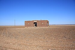
Mesquite school (abandoned)
Relief map of Texas.png
Red pog.svg
Mesquite
Usa edcp relief location map.png
Red pog.svg
Mesquite
Coordinates: 32°52′13″N101°37′49″W / 32.87028°N 101.63028°W / 32.87028; -101.63028 Coordinates: 32°52′13″N101°37′49″W / 32.87028°N 101.63028°W / 32.87028; -101.63028
Country Flag of the United States.svg  United States
State Flag of Texas.svg  Texas
County Borden
Physiographic region Llano Estacado
Founded1905
Elevation
[1]
2,966 ft (904 m)
Time zone UTC-6 (Central (CST))
  Summer (DST) UTC-5 (CDT)
Area code(s) 806
Website Handbook of Texas

Mesquite is a former town in Borden County, Texas, United States. From its inception, Mesquite remained a rural farming community. A school, established in 1905, served the area until 1952, after which the building appears to have been abandoned. Today, all that remains at the site of Mesquite are a Church of Christ, several scattered houses, and the abandoned schoolhouse. [2] The rest of the town appears to have been subsumed by private farms for cropland.

Contents

Geography

Mesquite is located on Farm to Market 1054, east of US Route 87 and north of US Route 180. The nearest large community is Lamesa, about 15 miles (24 km) to the southwest. It is also located 16 miles (26 km) northwest of Gail, 55 miles (89 km) north of Big Spring, and 7 miles (11 km) south of the Lynn County line. [3]

See also

Related Research Articles

Borden County, Texas County in Texas, United States

Borden County is a rural county located in the U.S. state of Texas. It is in West Texas and its county seat is Gail.

Mesquite, Texas City in Texas, United States

Mesquite is a suburban city located east of the city of Dallas, Texas, in the United States. Most of the city is located in Dallas County, though a small portion extends into Kaufman County. As of 2019 census estimates, the population was 140,937, making it the 22nd-most populous city in the U.S. state of Texas; in 2020, its population grew to 150,108. Mesquite is positioned at the crossroads of four major highways, making locations such as downtown Dallas, Lake Ray Hubbard, Dallas Love Field, and DFW International Airport accessible.

Glidden, Texas Census-designated place in Texas, United States

Glidden is an unincorporated community and census-designated place in Colorado County, Texas, United States. As of the 2010 census it had a population of 661. It lies just north of Interstate 10 and 3 miles (5 km) to the west of Columbus.

Wayside, Lynn County, Texas Unincorporated community in Texas, United States

Wayside is a small unincorporated community in Lynn County, Texas, United States. Today, the community is best described as a ghost town with only a few farms and ranches scattered across the area.

Double Mountains (Texas)

Double Mountains is the name of a pair of flat-topped buttes located 13 miles (21 km) southwest of Aspermont in Stonewall County, Texas. While the Handbook of Texas gives their elevation as either 2,000 ft (610 m) or 2,400 ft (732 m), United States Geological Survey maps give the elevation of the western mountain as 2,523 ft (769 m) and that of the eastern mountain as between 2,580 and 2,600 ft. Together, the mountains form part of the high ground dividing the watersheds of the Salt Fork and Double Mountain Fork Brazos River.

Wheelock, Texas Unincorporated community in Texas, United States

Wheelock is an unincorporated community in Robertson County, Texas, United States. It is located 15 miles northeast of Bryan and 11 miles southeast of Franklin. Wheelock is located on Farm to Market Road 46 and Farm to Market Road 391. It is part of the Bryan–College Station Metropolitan Statistical Area.

Cecil Township, Bottineau County, North Dakota Township in North Dakota, United States

Cecil Township is a civil township in Bottineau County in the U.S. state of North Dakota. As of the 2000 census, its population was 28.

Williams Ranch is the oldest settlement in Mills County, Texas, now a ghost town, with the oldest known cemetery in the vicinity dating back to the mid-19th century. The location is about 3 miles (4.8 km) south of Mullin, and 8 miles (13 km) northwest of Goldthwaite, the county seat. When originally settled, Williams Ranch was located in the far southern portion of what is now Brown County.

Peggy is an unincorporated community in Atascosa County, Texas, United States. According to the Handbook of Texas, the community had a population of 22 in 2000. It is located within the San Antonio metropolitan area.

Sagerton, Texas Place in Texas, United States

Sagerton is an unincorporated community in Haskell County, Texas, United States.

Teaselville, also known as Loftin, is an unincorporated community in Smith County, Texas, United States. Teaselville is located at the junction of Farm to Market Road 344 and Farm to Market Road 346, 4 miles (6.4 km) west of Bullard.

Patricia, Texas Unincorporated community in Texas, United States

Patricia is an unincorporated community in Dawson County, Texas, United States.

Mount Selman is an unincorporated community in Cherokee County, Texas, United States. It is located at the junction of U.S. Route 69, Farm to Market Road 177, and Farm to Market Road 855, 20 miles (32 km) north of Rusk.

Plains, Borden County, Texas Unincorporated community in Texas, United States

Plains is an unincorporated community on the high plains of the Llano Estacado in Borden County, Texas, United States. Plains is located on Farm to Market Road 1054, 15 miles (24 km) northwest of Gail. Oddly, it is not on many roadmaps, although its nearest Borden County neighbor, the defunct town Mesquite, on the same road, is.

Heckville, Texas Unincorporated community in Texas, United States

Heckville is an unincorporated community located on the high plains of the Llano Estacado about 16 mi (26 km) northeast of Lubbock or 7 mi (11 km) north of Idalou in northeastern Lubbock County, Texas. This small town was named after Henry Heck, who built a cotton gin to serve the community in 1948.

Salt Fork Brazos River River

The Salt Fork Brazos River is a braided, highly intermittent stream about 150 mi (240 km) long, heading along the edge of the Llano Estacado about 26 mi (42 km) east-southeast of Lubbock, Texas. From its source, it flows generally east-southeastward to join the Double Mountain Fork to form the Brazos River about 18 mi (29 km) west-northwest of Haskell, Texas. The Salt Fork stretches across portions of Crosby, Garza, Kent, and Stonewall counties of West Texas.

Rexville or Reckville was an unincorporated area in Austin County, in the U.S. state of Texas. The former location of the community, now a ghost town, is in a rural area between Sealy in Austin County and Eagle Lake in Colorado County. The name Rexville is still used to identify a United States Geological Survey (USGS) quadrangle map.

Mackay, Texas Unincorporated community in Texas, United States

Mackay is an unincorporated community in central Wharton County, in the U.S. state of Texas. The once thriving community is located on U.S. Route 59 (US 59) southwest of Wharton near Wharton Regional Airport. Mackay began as a railroad stop near a large ranch in 1881 and saw an influx of immigrants beginning in 1907. The community had its own post office from 1921 to 1937 but most of the buildings were gone by 1990. There were two businesses and a grain silo at the site in 2014.

Kanauga is an unincorporated community and census-designated place (CDP) in Gallia County, Ohio, United States. As of the 2010 census it had a population of 175.

House Rock is a ghost town near the northwest end of the House Rock Valley in northern Coconino County, Arizona, United States. The community was named after the House Rock Valley, which was named by the John Wesley Powell Expedition in 1871.

References

  1. "Mesquite". Geographic Names Information System . United States Geological Survey.
  2. Davis, Charles G. "Mesquite, TX (Borden County)". Handbook of Texas Online. Retrieved February 3, 2011.
  3. "Mesquite, Texas". Texas Escapes Online Magazine. Retrieved 2022-08-22.