Milford Sidings

Last updated

Milford Sidings
Location
Location South Milford, North Yorkshire, England
Coordinates 53°46′18″N1°14′14″W / 53.7718°N 1.2371°W / 53.7718; -1.2371 Coordinates: 53°46′18″N1°14′14″W / 53.7718°N 1.2371°W / 53.7718; -1.2371
OS grid SE504308
Characteristics
Owner Network Rail
TypeWagon storage sidings
Roads11 dead end sidings, 9 through sidings
History
Opened1983
BR region Eastern

Milford Sidings are a set of railway sidings in South Milford, North Yorkshire, England. The railways through the site were initially opened in 1834 and 1840, when transfer and marshalling yards opened too, which handled mostly coal. However, the current sidings were developed in the 1980s to function as layover (staging in railway parlance) [1] sidings for coal trains to and from the Aire Valley power stations. The sidings have access to several railway lines radiating in almost all directions.

Contents

With the drawdown of coal-fired power stations in line with UK government directives, the sidings have been used less due to the loss of coal trains. However, they are still used to stage other freight trains.

History

The first railway through the area was opened in September 1834 as the Leeds and Selby Railway, which ran on a east/west formation north of the Milford Sidings site, and this line is the present Leeds to Hull (via Selby) line. [2] The second line ran in a north/south direction under the Leeds and Selby at Milford connecting York with Normanton as the York and North Midland Railway. [3] This second line, with a south to east facing connection to the Leeds and Selby railway, was completed in 1840. [4] This allowed passengers to and from Hull, to change trains at Milford Junction station, when previously, they had to change at Sherburn-in-Elmet station. [5]

A large hump marshalling yard covering 47 acres (19 ha), was built at Gascoigne Wood on the Leeds to Selby line, which had access to the former York and North Midland Line, both to the north and south. [6] [7] This yard was one of several hump yards built by the North Eastern Railway (NER) (others being at Stockton, York and Hull), and consisted of at least 28 lines grouped on either side of the main line. [8] Sidings were also present at the site of Milford Junction station, in the same place as the re-laid sidings of the 1980s, however, these later sidings have taken up the area formerly used by Milford Junction station. [9]

Hensall, Milford Selby on the right. This shows Hagg Lane as being a station. Garnqueen Gartsherrie & Whifflet. Hensall, Milford Selby & Cliff Common RJD 28.jpg
Hensall, Milford Selby on the right. This shows Hagg Lane as being a station.

With the opening of the Selby 'Super Pit' complex, which had a loading terminal at Gascoigne Wood, the need for some sidings to stage and store coal wagons nearby was needed, and these were installed at Milford Junction between 1980 and 1983. [10] To enable the new sidings to have access to the running lines to Gascoigne Wood and to the north via York, the curve from Gascoigne Wood to Milford Junction was slewed outwards (towards the east) to accommodate the new sidings. [11] These twelve new sidings, [12] the associated sidings, and loading area at Gascoigne Wood cost £47 million, £1.5 million of which was provided by the EEC. Six through sidings and six dead-end sidings were built between the lines going north to York, and the curve to Gascoigne Wood as part of the Selby Diversion programme. [13] The sidings are used as a staging point for freight trains transiting across Great Britain. When the Aire Valley power stations were receiving deliveries of coal, loaded and empty coal wagons were stored in the sidings until they were needed for their next task. [14] The sidings provide access to lines through Castleford, Pontefract, Knottingley, Swinton, Goole and Doncaster to the south, to Selby, Hull in the east, and York to the north. [15] The Selby Coalfield complex was estimated to be produced over 10,000,000 tonnes (11,000,000 tons) of coal by the late 1980s, resulting in a loaded coal train leaving Gascoigne Wood every 30 minutes during Monday to Friday. This necessitated the expansive sidings at Milford. [16]

Wagon maintenance was undertaken at the sidings in a limited capacity, however, wagons were taken from Milford Sidings to the traction maintenance depot at Knottingley some 5 miles (8 km) south for more in-depth work. [17] The shunter allocated to Knottingley would undertake this duty moving wagons between the two sites. [18]

With the downturn in the electricity supply industry (ESI) coal trains due to power station closures, [19] many redundant coal hopper wagons have been stored at both sets of sidings either side of the main north/south lines. [20] The site has also been used to store redundant Mk 3 coaches from displaced Intercity 125 sets which have been superseded by newer trains on the East Coast Main Line. [21] Milford Down yard was used as a temporary offloading point for desulphogypsum from Drax Power Station bound for the gypsum plant at nearby Sherburn-in-Elmet in 2007. However, this was deemed unsuitable because of the need to move the desulphogypsum on public roads to the plant. The former rail terminal at Gascoigne Wood was utilised instead. [22] [23]

Related Research Articles

<span class="mw-page-title-main">Dearne Valley line</span> Railway line in Yorkshire, England

The Dearne Valley line is the name given to a railway line in the north of England running from York to Sheffield via Pontefract Baghill and Moorthorpe. The route was built over several years and consists of lines built by several railway companies.

The Pontefract line is one of the rail services in the West Yorkshire Metro area of northern England. The service is operated by Northern, and links Wakefield and Leeds with Goole via Pontefract. The Metro timetable for the line also includes services operated as the Dearne Valley line between York and Sheffield via Pontefract.

<span class="mw-page-title-main">Sherburn in Elmet</span> Village and civil parish in North Yorkshire, England

Sherburn in Elmet is a large village, civil parish and electoral ward in the Selby District of North Yorkshire, England, west of Selby and south of Tadcaster.

<span class="mw-page-title-main">Goole railway station</span> Railway station in East riding of Yorkshire, England

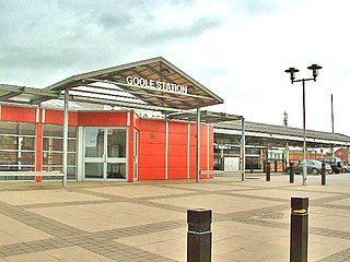
Goole railway station is a railway station in town of Goole on the Hull and Doncaster Branch in the East Riding of Yorkshire, England.

<span class="mw-page-title-main">Pontefract Monkhill railway station</span> Railway station in West Yorkshire, England

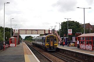
Pontefract Monkhill railway station is the busiest station in the town of Pontefract, West Yorkshire, England. The station is on the Pontefract Line managed by Northern but is also served by Grand Central and is 14 miles (23 km) south east of Leeds.

<span class="mw-page-title-main">Knottingley railway station</span> Railway station in West Yorkshire, England

Knottingley railway station serves the town of Knottingley in West Yorkshire, England. It lies on the Pontefract Line, operated by Northern, and is 16 miles (26 km) south east of Leeds railway station.

<span class="mw-page-title-main">Selby railway station</span> Railway station in North Yorkshire, England

Selby railway station is a Grade II listed station which serves the town of Selby in North Yorkshire, England. The original terminus station was opened in 1834 for the Leeds and Selby Railway. The Hull and Selby Railway extended the line in 1840, and a new station was built, with the old station becoming a goods shed. The station was rebuilt in 1873 and 1891, the 1891 rebuilding being required due to the replacement of the swing bridge over the Ouse at the same time.

<span class="mw-page-title-main">South Milford railway station</span> Railway station in North Yorkshire, England

South Milford railway station serves the villages of South Milford and Sherburn in Elmet in North Yorkshire, England. It lies on the Selby Line 13 miles (21 km) east of Leeds.

<span class="mw-page-title-main">Church Fenton railway station</span> Railway station in North Yorkshire, England

Church Fenton railway station serves Church Fenton in North Yorkshire, England. It is on the former York and North Midland Railway main line from York to Normanton, just under 10.75 miles (17 km) from York.

<span class="mw-page-title-main">Sherburn-in-Elmet railway station</span> Railway station in North Yorkshire, England

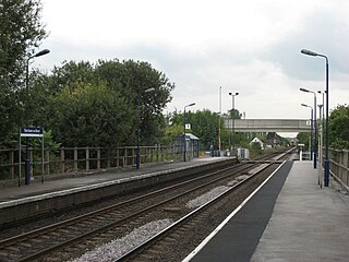
Sherburn-in-Elmet railway station serves the village of Sherburn in Elmet near Selby in North Yorkshire, England. The station is located approximately 1 mile (1.6 km) from the village and is 12.75 miles (21 km) south of York.

<span class="mw-page-title-main">Gilberdyke railway station</span> Railway station in the East Riding of Yorkshire, England

Gilberdyke railway station is a railway station that serves the village of Gilberdyke in the East Riding of Yorkshire, England. It was opened in 1840 by the Hull and Selby Railway, and until 1974 it was known as Staddlethorpe station. Today it is operated by the Northern train operating company. Situated 17 miles (27 km) west of Hull, it is the junction for the lines to Selby and to Goole and Doncaster.

<span class="mw-page-title-main">Hensall railway station</span> Railway station in North Yorkshire, England

Hensall railway station serves the village of Hensall in North Yorkshire, England. It is located on the Pontefract Line and is 22 miles (35 km) east of Leeds. The line is used regularly by the freight companies GB Railfreight, Freightliner and DB Cargo UK that transport coal and limestone to Drax and remove the gypsum created by the flue-gas treatment equipment. The branch line to the power plant diverges just to the east of the station and was formerly supervised from the nearby signal box, but is now remotely controlled from Ferrybridge signalling centre.

The Leeds and Selby Railway was an early British railway company and first mainline railway within Yorkshire. It was opened in 1834.

<span class="mw-page-title-main">Selby Coalfield</span>

Selby coalfield was a large-scale deep underground mine complex based around Selby, North Yorkshire, England, with pitheads at Wistow Mine, Stillingfleet Mine, Riccall Mine, North Selby Mine, Whitemoor Mine and at Gascoigne Wood Mine; all coal was brought to the surface and treated at Gascoigne Wood, being distributed onwards by rail. The primary purpose of the pit was to supply coal for electrical power generation; much of it was used in the nearby Aire valley power stations.

The Hull and Doncaster Branch is a secondary main railway line in England, connecting Kingston upon Hull to South Yorkshire and beyond via a branch from the Selby Line near Gilberdyke to a connection to the Doncaster–Barnetby line at a junction near Thorne 8 miles north-east of Doncaster.

<span class="mw-page-title-main">Knottingley TMD</span> Disused railway traction shed in West Yorkshire, England

Knottingley TMD was a traction maintenance depot located in Knottingley, West Yorkshire, England. The depot was situated on the Pontefract Line and was near Knottingley station. It opened in 1967 to maintain the locomotives and hopper wagons for a planned 75 Merry-go-round trains a day, expected to use the Wakefield and Goole line.

<span class="mw-page-title-main">Leeds Midland Road depot</span> Railway locomotive and rolling stock depot in Leeds, England

Leeds Midland Road depot is a locomotive and rolling stock maintenance facility located in Leeds, West Yorkshire, England. The site is located a few miles to the south-west of Leeds station on the line between Leeds and Castleford. Owned and operated by Freightliner, it is the heavy maintenance facility for its diesel and electric locomotives and wagon fleet.

<span class="mw-page-title-main">Basford Hall Yard</span> Railway yard in Crewe, Cheshire, England

Basford Hall Yard is a railway marshalling yard near the town of Crewe, Cheshire, England. The yard, which is 0.93 miles (1.5 km) south of Crewe railway station, was opened in 1901 by the London and North Western Railway (LNWR). Initially used to marshal trains, the site now acts as a hub mainly for Freightliner intermodal trains, but also houses departmental sidings as used by Freightliner Heavy Haul, and other operators. For a period in the 1930s, Basford Hall was the busiest marshalling yard in Europe, handing between 28,000 and 47,000 wagons every week.

<span class="mw-page-title-main">Monk Fryston railway station</span> Disused railway station in North Yorkshire England

Monk Fryston railway station was a railway station serving the village of Monk Fryston in North Yorkshire, England. Previously, Milford Junction and Old Junction served as an interchange between the Leeds and Selby and the York and North Midland Lines, however when they closed in the early 1900s, Monk Fryston was opened to cover for this loss of interchange. Though the station had four tracks through it, it only ever had two platforms. The station closed to passengers in 1959, and then completely in 1964.

Gascoigne Wood Junction railway station was a railway station near Sherburn-in-Elmet in North Yorkshire, England. It was originally opened as a junction station, enabling transfers for passengers between trains. It was later a private halt station for the staff who worked at the Gascoigne Wood marshalling yard. It opened in 1839, and was closed, renamed and re-opened several times before closing completely in 1959. The station was 14 miles (23 km) from Leeds New Station, and 6 miles (9.7 km) from Selby.

References

  1. Butcher, Louise (12 December 2016). "Rail Freight" (PDF). researchbriefings.files.parliament.uk. House of Commons. p. 12. Retrieved 21 March 2022.
  2. Mitchell, Vic; Smith, Keith (2020). Leeds to Selby and Goole. Midhurst: Middleton Press. p. 4. ISBN   978-1-910356-47-0.
  3. Body 1989, p. 178.
  4. Tomlinson 1915, p. 273.
  5. Tomlinson 1915, p. 342.
  6. "Sherburn-in-Elmet Parish (1950s)". maps.nls.uk. Retrieved 10 November 2021.
  7. Kershaw, Ronald (24 June 1974). "Coal Board aims to use railway site as focal point for Selby operations". The Times. No. 59122. p. 13. ISSN   0140-0460.
  8. Rhodes, Michael (2016). From gridiron to grassland. Sheffield: Platform 5. pp. 53, 55. ISBN   978-1-909431-25-6.
  9. "Milford Junction". maps.nls.uk. Retrieved 22 February 2022. Use the slider to toggle between mapping from older mapping and modern day satellite imagery
  10. Monk-Steel, David (2011). Merry-go-round : on the rails. Ripley: Historical Model Railway Society. p. 74. ISBN   978-0-902835-30-6.
  11. Chapman 2002, p. 8.
  12. Body 1989, p. 73.
  13. Skoyles, James (May 2021). "Aire Valley Coal". Railways Illustrated. Vol. 19, no. 5. Horncastle: Mortons Media. p. 53. ISSN   1479-2230.
  14. Shannon, Paul (2012). EWS : from privatisation to DB. Hersham: Ian Allan. p. 39. ISBN   978-0-7110-3520-1.
  15. Kelman, Leanne (2020). Railway track diagrams, books 2 - eastern (5 ed.). Frome: Trackmaps. Introduction page. ISBN   978-1-9996271-3-3.
  16. Sill, David (1985). "The Selby Coalfield Project: progress to 1984". Geography. Sheffield: Geographical Association. 70 (1): 71. ISSN   0016-7487. OCLC   983211363.
  17. Kelman, Leanne (2020). Railway track diagrams, books 2 - eastern (5 ed.). Frome: Trackmaps. 40A. ISBN   978-1-9996271-3-3.
  18. Bendell, Simon (May 2013). "Shunter Spot". Rail Express. No. 204. Peterborough: Mortons Media. p. 50. ISSN   1362-234X.
  19. Thomas, Nathalie; Hook, Leslie; Tighe, Chris (1 October 2019). "How Britain ended its coal addiction" . Financial Times. Retrieved 21 March 2022.
  20. Bickerdyke, Paul, ed. (January 2021). "Storage space created at Worksop with clearout of redundant wagons". Rail Express. No. 296. Horncastle: Mortons Media. p. 13. ISSN   1362-234X.
  21. Bickerdyke, Paul, ed. (July 2020). "Coaches - shed talk". Rail Express. No. 290. Horncastle: Mortons Media. p. 29. ISSN   1362-234X.
  22. "Opposition to gypsum move" . infoweb.newsbank.com. 18 October 2007. Retrieved 29 January 2022.
  23. "Rail deal will reduce roads' load" . infoweb.newsbank.com. 29 December 2007. Retrieved 29 January 2022.

Sources