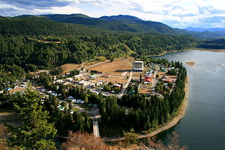
Metaline Falls is a town in Pend Oreille County, Washington, United States. The population was 272 at the 2020 census.

Cheney is a city in Spokane County, Washington, United States. The full-time resident population was 13,255 as of the 2020 census. Eastern Washington University is located in Cheney. When classes are in session at EWU, the city's population reaches approximately 17,600 people temporarily.

Lamont is a town in Whitman County, Washington, United States. The population was 79 at the 2020 census.

Historic Washington State Park is a 101-acre (41 ha) Arkansas state park in Hempstead County, Arkansas in the United States. The museum village contains a collection of pioneer artifacts from the town of Washington, Arkansas, which is a former pioneer settlement along the Southwest Trail. Walking interpretive tours are available throughout the 54 buildings. Washington served as a major trading point along the Southwest Trail, evolving into the Hempstead county seat and later the capital of Arkansas from 1863 to 1865 when Little Rock was threatened during the Civil War. The original plat of Washington was added to the National Register of Historic Places in 1972 as the Washington Historic District.

Benge is an unincorporated community in Adams County, Washington. Benge School District serves the community, and downtown Benge contains Benge Elementary School.
Star Junction is an unincorporated community and census-designated place in Perry Township, Fayette County, Pennsylvania, United States. The community is located on Pennsylvania Route 51. At the 2010 census, the population was 616.

Ward Charcoal Ovens State Historic Park is an area designated for historic preservation and public recreation located 20 miles (32 km) south of the town of Ely in White Pine County, Nevada. The 700-acre (280 ha) state park protects beehive-shaped charcoal ovens constructed in the latter half of the 19th century.

Hells Canyon National Recreation Area is a United States national recreation area on the borders of the U.S. states of Oregon and Idaho. Managed by the U.S. Forest Service as part of the Wallowa-Whitman National Forest, the recreation area was established by Congress and signed by President Gerald Ford in late 1975 to protect the historic and archaeological values of the Hells Canyon area and the area of the Snake River between Hells Canyon Dam and the Oregon–Washington border.

Mount Spokane State Park is a public recreation area in the northwest United States, located in the Selkirk Mountains, 23 miles (37 km) northeast of the city of Spokane, Washington. The state park surrounds 5,883-foot (1,793 m) Mount Spokane and other peaks including Mount Kit Carson, Beauty Mountain, and Quartz Mountain.

The Columbia Plateau State Park Trail is a 130-mile-long (210 km), 20-foot-wide (6.1 m) corridor in eastern Washington state maintained as part of the Washington State Park system. The rail trail runs along the abandoned right-of-way of the former Spokane, Portland and Seattle Railway.

Marshall is an unincorporated community in Spokane County, Washington, United States. Named in 1880 for early settler William H. Marshall, Marshall has a post office with ZIP code 99020.
Mica is an unincorporated community in Spokane County, Washington, United States. Mica is located along State Route 27 12 miles (19 km) southeast of downtown Spokane. Mica had a post office with ZIP code 99023.
Longview is an unincorporated historic community in Benton County, Washington, United States, located approximately three miles west of Umatilla, Oregon on the north bank of the Columbia River, just above Devil's Bend Rapids.
Gate is an unincorporated community in Thurston County, Washington, United States. Gate is located on the Black River, 2.9 miles (4.7 km) west-northwest of Rochester.
Bakeoven is an unincorporated community in Wasco County, in the U.S. state of Oregon. It is southeast of Maupin and northwest of Shaniko along Bakeoven Creek, a tributary of the Deschutes River.
Alderdale is an extinct town in Klickitat County, in the U.S. state of Washington. The GNIS classifies it as a populated place.

Buckeye is an unincorporated community in Spokane County, in the U.S. state of Washington. It is located along the Little Spokane River in the northern portion of the county.

Peone is an unincorporated community in Spokane County, in the U.S. state of Washington.
Rodna is an extinct town in Spokane County, in the U.S. state of Washington. The GNIS classifies it as a populated place.

Deep Creek is a stream of approximately 23 miles which is formed at the confluence of the North Fork Deep Creek and South Fork Deep Creek two miles southwest of the community of Deep Creek, Washington on the far western edge of Spokane County. The creek has its mouth at the Spokane River in Riverside State Park where it cuts a thin canyon through basalt with depths reaching over 600 feet from the land above. The creek and its tributaries flow through mostly rural agricultural areas west of the Spokane urban area, though the headwaters and mouth are both located on state-owned conservation land.

