
Lincoln is a cathedral city and district in Lincolnshire, England, of which it is the county town. In the 2021 Census, the city's district had a population of 103,813. The 2021 census gave the urban area of Lincoln, including Bracebridge Heath, North Hykeham, South Hykeham and Waddington, a recorded population of 127,540.

Boston is a market town and inland port in the borough of the same name in the county of Lincolnshire, England.
Ermine Street is a major Roman road in England that ran from London (Londinium) to Lincoln and York (Eboracum). The Old English name was Earninga Strǣt (1012), named after a tribe called the Earningas, who inhabited a district later known as Armingford Hundred, around Arrington, Cambridgeshire, and Royston, Hertfordshire. "Armingford", and "Arrington" share the same Old English origin. The original Celtic and Roman names for the route remain unknown. It is also known as the Old North Road from London to where it joins the A1 Great North Road near Godmanchester.

The Fosse Way was a Roman road built in Britain during the first and second centuries AD that linked Isca Dumnoniorum (Exeter) in the southwest and Lindum Colonia (Lincoln) to the northeast, via Lindinis (Ilchester), Aquae Sulis (Bath), Corinium (Cirencester), and Ratae Corieltauvorum (Leicester).
Sleaford is a market town and civil parish in the North Kesteven district of Lincolnshire, England. On the edge of the Fenlands, it is 11 miles north-east of Grantham, 16 mi (26 km) west of Boston, and 17 mi (27 km) south of Lincoln. It is the largest settlement in North Kesteven with a population of 19,807 in 2021. Centred on the former parish of New Sleaford, the modern boundaries and urban area include Quarrington to the south-west, Holdingham to the north-west and Old Sleaford to the east. The town is bypassed by the A17 and the A15 roads, which link it to Lincoln, Newark, Peterborough, Grantham, Boston and King's Lynn. Sleaford railway station is on the Nottingham to Skegness and Peterborough to Lincoln lines.

Icknield Street or Ryknild Street is a Roman road in England, with a route roughly south-west to north-east. It runs from the Fosse Way at Bourton on the Water in Gloucestershire to Templeborough in South Yorkshire. It passes through Alcester, Studley, Redditch, Metchley Fort, Birmingham, Sutton Coldfield, Lichfield, Burton upon Trent and Derby.

Horncastle is a market town and civil parish in the East Lindsey district in Lincolnshire, England. It is 17 miles (27 km) east of Lincoln. Its population was 6,815 at the 2011 census and estimated at 7,123 in 2019. A section of the ancient Roman walls remains.

Monks Risborough is a village and ecclesiastical parish in the civil parish of Princes Risborough, Buckinghamshire, England, lying between Princes Risborough and Great Kimble. The village lies at the foot of the northern scarp of the Chiltern Hills. It is 8 miles (13 km) south of the county town of Aylesbury and 9.5 miles (15.3 km) north of High Wycombe, on the A4010 road.

Louth is a market town and civil parish in the East Lindsey district of Lincolnshire, England. Louth serves as an important town for a large rural area of eastern Lincolnshire. Visitor attractions include St James' Church, Hubbard's Hills, the market, many independent retailers, and Lincolnshire's last remaining cattle market.

Stamford is a town and civil parish in the South Kesteven district of Lincolnshire, England. The population at the 2011 census was 19,701 and estimated at 20,645 in 2019. The town has 17th- and 18th-century stone buildings, older timber-framed buildings and five medieval parish churches. It is a frequent film location. In 2013 it was rated a top place to live in a survey by The Sunday Times. Its name has been passed on to Stamford, Connecticut, founded in 1641.

North Kesteven is a local government district in Lincolnshire, England. The council is based in Sleaford. The district also contains the town of North Hykeham, which adjoins the neighbouring city of Lincoln, along with numerous villages and surrounding rural areas.
Market Rasen is a market town and civil parish within the West Lindsey district of Lincolnshire, England. The River Rase runs through it east to west, approximately 13 miles (21 km) north-east from Lincoln, 18 miles (29 km) east from Gainsborough, 14 miles (23 km) west of Louth, and 16 miles (26 km) south-west from Grimsby. It lies on the main road between Lincoln and Grimsby, the A46, and is famous for its racecourse. In 2001, the town had a population of 3,200. In the 2011 census, the population of the civil parish was 3,904.

Monk Bretton is a village in the Metropolitan Borough of Barnsley in South Yorkshire, England. It lies approximately two miles north-east from Barnsley town centre. Until 1974 it was in the West Riding of Yorkshire.

Whalley is a large village and civil parish in the Ribble Valley on the banks of the River Calder in Lancashire, England. It is overlooked by Whalley Nab, a large wooded hill over the river from the village. The population of the civil parish was 2,645 at the census of 2001, and increased to 3,629 at the census of 2011.
Mablethorpe is a seaside town in the civil parish of Mablethorpe and Sutton, in the East Lindsey district of Lincolnshire, England. In 1961 the civil parish had a population of 3,611. On 1 April 1974 the parish was changed to form "Mablethorpe and Sutton". The population including nearby Sutton-on-Sea was 12,531 at the 2011 census and estimated at 12,633 in 2019.

Saxilby is a village and civil parish in the West Lindsey district of Lincolnshire, England, about 6 miles (9.7 km) north-west from Lincoln, on the A57 road at the junction of the B1241. It is part of the civil parish of Saxilby and Ingleby, which includes the village of Ingleby. The population of the civil parish in 2001 was 3,679, increasing to 3,992 at the 2011 census.

Little Ponton is a village in the civil parish of Little Ponton and Stroxton, in the South Kesteven district of Lincolnshire, England. It lies 2 miles (3 km) south of Grantham, about 60 metres (200 ft) above sea level.

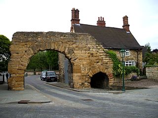
St Mary Magdalene was a Benedictine priory in Lincoln, England. Along with Sandtoft Priory and Hanes Cell, it was a Lincolnshire cell of St Mary's Abbey in York, England. A surviving building, once owned by the priory, is Monks' Abbey, Lincoln.

Abbey is one of eleven electoral districts within the City of Lincoln Council. As of 2023, the Liberal Democrats hold all three seats in the ward having first taken a seat in the 2021 local elections being the first time a non-Labour Party candidate had won a seat in the ward since 1979. The ward is split between two Lincolnshire County Council divisions, St Giles in the north and Park in the south who respectively have elected a Conservative and Labour county councillor.

The A1500 is an A road entirely within the English county of Lincolnshire. It links the A156 at Marton with the A15 south of RAF Scampton via Sturton by Stow.

