Terenzio, Count Mamiani della Rovere was an Italian writer, academic, diplomat and politician, and was committed to the cause of the unification of Italy under the Sardinian monarchy. He was one of the leading figures of Liberal Catholicism.

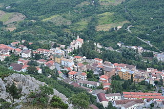
Pacentro is a comune of 1,279 inhabitants of the province of L'Aquila in Abruzzo, Italy. It is a well-preserved historic medieval village located in central Italy, several kilometers from the City of Sulmona about 170 kilometres (110 mi) east of Rome. It is one of I Borghi più belli d'Italia.

Lama dei Peligni is a comune and town in the province of Chieti in the Abruzzo region of Italy with 1,155 inhabitants. It is also part of the Aventino-Medio Sangro mountain community and the municipal territory is included in the Maiella National Park. The town, known to naturalists as the country of chamois, is located in a florofaunal area of particular interest.
Taranta Peligna is a comune and town in the province of Chieti in the Abruzzo region of central Italy. It is 57 kilometres (35 mi) from Chieti.

Bugnara is a comune and village in the province of L'Aquila in the Abruzzo region of southern Italy. It is one of I Borghi più belli d'Italia.

Campo di Giove is a town and comune in the province of L'Aquila in the Abruzzo region of central Italy. Its territory is included in the Majella National Park. Located at the foot of the southwestern slope of the Majella, it is a holiday resort in summer and winter, thanks to the presence of a ski station. In English, its name means 'Campus Jovis'.

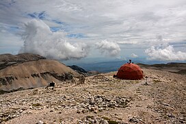
Maiella National Park is located in the provinces of Chieti, Pescara and L'Aquila, in the region of Abruzzo, Italy. It is centered on the Maiella massif, of which Monte Amaro is the highest peak, at 2,793 m (9,163 ft) elevation.

The Maiella (or Majella) is a massif in the Central Apennines, in Abruzzo, central Italy.
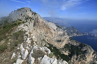
Monte Solaro is a mountain on the island of Capri in Campania, Italy. With an elevation of 589 m, its peak is the highest point of Capri.

Carrara-Avenza railway station, also known simply as Carrara or Avenza, is a railway station of the city of Carrara, Italy. It is located on the Genova-Pisa line. It is the only station serving the Tuscan city, after the closure of Carrara San Martino in 1969.

Vittorio (Vito) Lattanzio was an Italian Christian Democrat politician and physician.
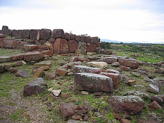
Monte Sirai is an archaeological site near Carbonia, in the province of South Sardinia, Sardinia, Italy. It is a settlement built at the top of a hill by the Phoenicians of Sulci. The history of studies in Monte Sirai has a very precise date: the fall of 1962, when a local boy casually found a female figure carved on a stele of the tophet. Following further inspections, in August 1963, the local Soprintendenza and the Institute of Near Eastern Studies of the Sapienza University of Rome started excavations, leading to a fairly comprehensive study of the entire town.
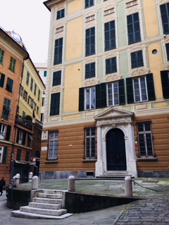
The Palazzo Clemente della Rovere is a palace located in Piazza Rovere in the historical center of Genoa, Northwestern Italy. The palace was one of the 163 Palazzi dei Rolli of Genoa, the selected private residences where the notable guests of the Republic of Genoa were hosted during State visits. On 13 luglio 2006 it was added to the list of 42 palaces which now form the UNESCO World Heritage Site Genoa: Le Strade Nuove and the system of the Palazzi dei Rolli. The palace hosts today the General Consulate of Iceland.
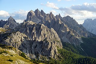
Cadini di Misurina is a group of mountains in the eastern Dolomites in the Province of Belluno, Italy. These mountains rise to the west of Auronzo di Cadore, north-east of Cortina d'Ampezzo and south of Dobbiaco, in a position overlooking Lake Misurina. They are part of the Dolomites subsection of Sesto, of Braies, and Ampezzo, and belong to the municipality of Auronzo di Cadore. The highest peak is the Cima Cadin of San Lucano.

The Mirandola mint, also known as the mint of the Pico della Mirandola, was the mint of the Duchy of Mirandola.
The 1706 Abruzzo earthquake, also known as the Maiella earthquake, occurred on November 3 at 13:00 CEST. The earthquake with a possible epicenter in the Central Apennine Mountains (Maiella), Abruzzo had an estimated moment magnitude of 6.6–6.84 Mw . It was assigned a maximum Mercalli intensity of XI (Extreme), causing tremendous destruction in Valle Peligna. At least 2,400 people were killed.
The Monte Alpe is a mountain of the Ligurian Prealps, the eastern section of the Ligurian Alps.

Mount Gimont is a mountain 2,646 m above sea level in the Montgenèvre Alps, in the Cottian Alps. It is located on the border between Italy and France (Hautes-Alpes).

Mount Porrara is a mountain in the Abruzzi Apennines, located between the lower province of L'Aquila and the province of Chieti, a natural geomorphological continuation south of the Maiella, included in the Maiella National Park.
Giuseppe Cannovale (1864–1938) was an Italian engineer, urban planner, and entrepreneur.