Monte Porrara

Last updated
Monte Porrara
Monte Porrara.JPG
View of Mount Porrara with the southern subpeak in front
Highest point
Elevation 2,137 m (7,011 ft)
Prominence 477 m (1,565 ft)
Isolation 5.59 [1]  km (3.47 mi)
Coordinates 41°57′57″N14°05′46″E / 41.9657°N 14.096°E / 41.9657; 14.096
Geography
Country Flag of Italy.svg Italy
Parent range Apennine Mountains

Mount Porrara (2137 m a.s.l.) is a mountain in the Abruzzi Apennines, located between the lower province of L'Aquila and the province of Chieti, a natural geomorphological continuation south of the Maiella, included in the Maiella National Park. [2]

Contents

Description

Geography

Cross present on the summit of Mount Porrara Monte Porrara - croce di vetta.JPG
Cross present on the summit of Mount Porrara

Its ridge develops for 9 km, in a north-south course from the Coccia ford (1674 m), the pass that joins it to the Maiella massif, to the vicinity of the Fork Pass (1276 m), from which the Quarto Santa Chiara plateau opens. [2] More precisely, its ridge includes, in its north-south development, in order, the following peaks: the summit of the La Paradina rock wall (1969 m), the north subpeak of Mount Porrara (1935 m), the Ogniquota summit (2100 m), Mount Pareti Rosse (2040 m), the summit of Mount Porrara (2137 m), the south subpeak of Mount Porrara (2092 m), and Mount Malvone (or Molione) (1729 m), coinciding with the plain and sierra of the same name. [3] Part of its territory falls within the perimeter of the Quarto Santa Chiara Nature Reserve. [4] Administratively, the two slopes of the mountain are included in the territory of the municipalities of Palena (eastern slope) and Campo di Giove (western slope), with its summit falling a few meters within the municipal territory of the latter, both of which are part of the Maiella National Park. [3] On its eastern slopes rises the Aventino River (springs of Capo di Fiume, fed by waters flowing from the Quarto Santa Chiara plateau located to the west), in the municipal territory of Palena, which originates the valley of the same name that opens eastward to the Adriatic Sea, while on its western slopes the Cerreto plain separates it from Mount Pizzalto (1966 m). [2] The rocks of the mountain are limestone. [2]

Flora and fauna

Iris Marsica 1.jpg
The Marsican iris, a flower species endemic to the mount.
GIPE25 - Un Loup (by) (2).jpg
The Apennine wolf, a typical wildlife species of the mount.

The flora and fauna present are purely mountainous and reflect the representative species of the reserve [4] and more broadly of the park and the Maiella massif itself. [5] In the forests, transitory high forest trees or the result of young reforestation, coppice and barren areas alternate with specimens of medium age, such as those in the Coste del Fonnone forest, [5] or centuries old, [6] predominantly represented by beech, interspersed sporadically with species of Lobel's maple, [7] sycamore maple, Italian maple, holly, [8] hornbeam, [9] European hop-hornbeam, turkey oak, chequer, European ash, manna ash, goat willow, and yew. [4] Timber [8] has been made from some of them in recent times. In the shrub pastures on the eastern slope, maythorn, blackthorn and dog rose are found as floral specimens. [10] Other floral species include the Adriatic lizard orchid and the Marsican iris, which, despite its name, is endemic to this mountain. [4] In addition, at low altitudes leek grows there spontaneously, which gives the mountain its name. [11] Among the fungi, there are strangulated amanita, grisette amanita, clitocybe phyllophila, megacollybia platyphylla, cortinarius infractus , mutinus caninus , lacrymaria lacrymabunda , lactarius deterrimus , lactarius blennius , clavulina cinerea , clavariadelphus pistillaris , spathularia flavida , tricholoma basirubens and lycoperdon umbrinum , which grow in the undergrowth. [12] The fauna present includes species that inhabit or frequent wooded areas, such as, in the case of large and small mammals, specimens of roe deer, red deer, wild boar, beech marten, [13] European wildcat, European hare, [9] Apennine wolf, pine marten, Marsican brown bear, red squirrel and red fox, and among birds, both raptor and non-prey, species of scops owl, [5] northern goshawk, barn owl, little owl, long-eared owl, white-backed woodpecker, buzzard and sparrowhawk, some with daytime and others with nocturnal habits. [4]

History

The hermitage of Madonna dell'Altare, located in the vicinity of the Taverna cave, where Pope Celestine V lived in the 13th century, at the time known as Pietro da Morrone MadonnaDell'Altare-Palena.JPG
The hermitage of Madonna dell'Altare, located in the vicinity of the Taverna cave, where Pope Celestine V lived in the 13th century, at the time known as Pietro da Morrone

The mountain was referred to as "Palleno" in Roman times, [14] from which the name of the municipality of Palena derives, with the meaning of "meadow on a steep slope." [15] The name in use, with the literal meaning of "leek mountain," refers instead to the herbaceous plant of the same name that grows there wild at the low altitudes of the eastern slope. [11] Mount Porrara hosted at different times three saints who came there in prayer: saint Falco, a hermit in the 11th century in a cave located between the mountain and the remaining Maiella massif, Pope Celestine V, at the time Pietro Angelerio and also known as Pietro da Morrone, a hermit in the 13th century in the Taverna cave, and saint Nicola da Forca Palena in the 14th century. [3] In particular, Pietro da Morrone, who came from Castel di Sangro, dug his own dwelling himself, where he lived between 1235 and 1238, when he headed to Rome to receive the priestly habit. [16] During the latter century, the Congregation of the Celestines built there the Hermitage of Madonna dell'Altare on a rock, located in the vicinity of the cave where their founder lived, dwelling there until 1807. [17] In 1943, at the height of World War II, the Germans, given the strategic location of Mount Porrara and its proximity to the Gustav Line, built trenches there, of which the ruins remain, and converted the religious building into a prison. [17] Throughout its history and to some extent to this day its heights were used for cattle grazing. [10]

Mountaineering routes

Pilate's lodges, the point of confluence of the various trails that cross Mount Porrara Monte Porrara - Logge di Pilato.JPG
Pilate's lodges, the point of confluence of the various trails that cross Mount Porrara

The mountaineering routes that traverse Mount Porrara consist of a number of trails that, in hiking circles, make it possible to reach its summit: the normal route traces an itinerary that crosses its crest after passing the wooded areas and the summit pastures and is a hybrid between the park path and the CAI's Grand Italian Trail [18] and is taken along the provincial road 12 Frentana, in the vicinity of the station of Palena, [6] while the direttissima route is formed by a pair of parallel paths, [8] in places overlapping and connected, [19] which originate from the Hermitage of Madonna dell'Altare, present on an altar-shaped rock that gives it its name, located along the eastern slopes of the mountain, and, after passing through wooded areas and shrubby pastures, climb up to the Pilate's Lodges, [10] natural terraces formed by stone boulders that bear the name of the character who characterized that place. [20]

See also

Related Research Articles

<span class="mw-page-title-main">Abruzzo</span> Region in Italy

Abruzzo, historically known as Abruzzi, is a region of Southern Italy with an area of 10,763 square km and a population of 1.3 million. It is divided into four provinces: L'Aquila, Teramo, Pescara, and Chieti. Its western border lies 80 km (50 mi) east of Rome. Abruzzo borders the region of Marche to the north, Lazio to the west and north-west, Molise to the south and the Adriatic Sea to the east. Geographically, Abruzzo is divided into a mountainous area in the west, which includes the highest massifs of the Apennines, such as the Gran Sasso d'Italia and the Maiella, and a coastal area in the east with beaches on the Adriatic Sea.

<span class="mw-page-title-main">Noto</span> City in Sicily, Italy

Noto is a city and comune in the Province of Syracuse, Sicily, Italy. It is 32 kilometres (20 mi) southwest of the city of Syracuse at the foot of the Iblean Mountains. It lends its name to the surrounding area Val di Noto. In 2002 Noto and its church were declared a UNESCO World Heritage Site.

<span class="mw-page-title-main">Province of Chieti</span> Province of Italy

The province of Chieti is a province in the Abruzzo region of Italy. Its provincial capital is the city Chieti, which has a population of 50,770 inhabitants. The province has a total population of 387,649 inhabitants as of 2017 and spans an area of 2,599.58 square kilometres (1,003.70 sq mi). It is divided into 104 comuni (comune) and the provincial president is Mario Pupillo.

<span class="mw-page-title-main">Province of Rieti</span> Province of Italy

The Province of Rieti is a province in the Lazio region of Italy. Its capital is the city of Rieti. Established in 1927, it has an area of 2,750.52 square kilometres (1,061.98 sq mi) with a total population of 157,887 people as of 2017. There are 73 comuni in the province.

<span class="mw-page-title-main">Pretoro</span> Comune in Abruzzo, Italy

Pretoro is a town of about 1,100 inhabitants situated in Majella National Park, in the province of Chieti, Abruzzo, southern Italy. It is located on a steep hillside on the eastern side of the Maiella mountains. Its proximity to Passo Lanciano-La Majelletta ski area, guarantees the availability of winter sports, while the town is also only 20 minutes by car from the Adriatic Sea. It is a member of the I Borghi più belli d'Italia association.

<span class="mw-page-title-main">Guardiagrele</span> Comune in Abruzzo, Italy

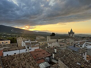
Guardiagrele is a town and comune in the province of Chieti, part of the Abruzzo region of central Italy. It is in the foothills of the Maiella mountain at an elevation of around 576 metres (1,890 ft). Its population numbers about 10,000.

<span class="mw-page-title-main">Archi, Abruzzo</span> Comune in Abruzzo, Italy

Archi is a town and comune in the province of Chieti, Abruzzo, southern Italy. It is part of the Valsangro mountain community.

Palena is a comune and town in the province of Chieti in the Abruzzo region of Italy.

<span class="mw-page-title-main">Civitella Messer Raimondo</span> Comune in Abruzzo, Italy

Civitella Messer Raimondo is a town in the province of Chieti in the Abruzzo region of Italy, with a population of 890. It is part of the mountain community of Aventino-Medio Sangro. Until 1863, it was known only as Civitella.

<span class="mw-page-title-main">Taranta Peligna</span> Comune in Abruzzo, Italy

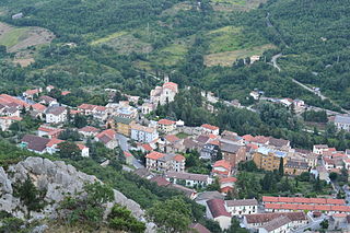
Taranta Peligna is a comune and town in the province of Chieti in the Abruzzo region of central Italy. It is 57 kilometres (35 mi) from Chieti.

<span class="mw-page-title-main">Campo di Giove</span> Comune in Abruzzo, Italy

Campo di Giove is a town and comune in the province of L'Aquila in the Abruzzo region of central Italy. Its territory is included in the Majella National Park. Located at the foot of the southwestern slope of the Majella, it is a holiday resort in summer and winter, thanks to the presence of a ski station. In English, its name means 'Campus Jovis'.

<span class="mw-page-title-main">Cansano</span> Comune in Abruzzo, Italy

Cansano is a comune in the province of L'Aquila in the Abruzzo region, Southern Italy. It is part of the Maiella National Park. Cansano is known for the archaeological discovery of the Italic and Roman town of Ocriticum, which has become an archaeological park.

<span class="mw-page-title-main">Maiella</span> Mountain massif in Abruzzo, Italy

The Maiella is a massif in the Central Apennines, in Abruzzo, central Italy.

<span class="mw-page-title-main">Tourism in Abruzzo</span> Place

Tourism in Abruzzo has become one of the most prosperous sectors in the economy of Abruzzo, and in recent years has seen a remarkable growth attracting numerous tourists from Italy and Europe. According to statistics, in 2021 arrivals totaled 1,330,887. A total of 5,197,765 arrivals were tourists, a figure that puts the region seventeenth among the Italian regions for numbers of tourists per year. A moderate support to tourism is also given to the Abruzzo Airport with many low cost and charter flights connecting the entire region with the rest of Europe.

<span class="mw-page-title-main">Abbey of the Holy Spirit at Monte Morrone, Sulmona</span>

The Abbey of the Holy Spirit at Morrone, known by various titles, is a former monastery some five kilometers outside of the town of Sulmona, at the base of Monte Morrone, in the Province of L'Aquila, region of Abruzzo, Italy.

<span class="mw-page-title-main">Hermitage of Madonna dell'Altare</span>

Eremo della Madonna dell'Altare is an hermitage located in Palena, Province of Chieti.

<span class="mw-page-title-main">Hermitage of Sant'Onofrio al Morrone</span>

Eremo di Sant'Onofrio al Morrone is an hermitage located in Sulmona, Province of L'Aquila ., dating back to the thirteenth century. A monk by the name of Pietro Angelerio living at this hermitage later became Pope Celestine V. The hermitage is located at an altitude of 620 meters, and can only be reached via a steep path from the village of Badia, on the eastern edge of the Valle Peligna.

<span class="mw-page-title-main">Monte Salviano</span> Italian mountain

Monte Salviano is a massif in the Abruzzo Apennines, Central Italy. It includes the peaks of Monte d'Aria, Monte Cimarani and Monte San Felice. Since 1999 the area, falling within the municipal territory of Avezzano, has been included in the Riserva Naturale di Monte Salviano.

<span class="mw-page-title-main">Riserva Naturale di Monte Salviano</span> Italian nature reserve

The Riserva Naturale di Monte Salviano or Riserva naturale guidata Monte Salviano is a nature reserve in Abruzzo, Italy, established in 1999. It lies in the territory of the comune (municipality) of Avezzano, in the Province of L'Aquila. The reserve is named after Monte Salviano, a massif that extends northwest to southwest dividing the Fucine basin from the Palentine Plains, in the Marsica sub-region.

<span class="mw-page-title-main">Monte Amaro (Abruzzo)</span> Mountain in Abruzzo, Italy

Mount Amaro is the highest mountain peak in the Maiella massif and the second highest in the Abruzzo region and the entire continental Apennines, after Gran Sasso's Corno Grande.

References

  1. Peakbagger.com
  2. 1 2 3 4 Parcomajella.it
  3. 1 2 3 Maiella National Park (2020), south sheet (front back).
  4. 1 2 3 4 5 "Riserva naturale orientata Quarto Santa Chiara".
  5. 1 2 3 "Riserva naturale orientata Quarto Santa Chiara".
  6. 1 2 "Sentiero del parco, tappa 4: da monte Amaro al Quarto Santa Chiara (stazione di Palena)".
  7. Pellegrini e Febbo (1998), pp. 161-165.
  8. 1 2 3 "Sentiero I3: dalla Madonna dell'Altare alla cresta del monte Porrara".
  9. 1 2 "Riserva nazionale Quarto Santa Chiara". Archived from the original on July 7, 2007.
  10. 1 2 3 "Sentiero I4: dalla Madonna dell'Altare alle "logge di Pilato"".
  11. 1 2 Giammarco (1990), p. 315; Sciarretta (1997), p. 90 e 103.
  12. Tieri (2009), p. 165, 169, 213, 218, 220, 236, 252, 320, 324, 369, 384, 408, 437 and 447.
  13. "Riserva naturale statale Quarto Santa Chiara".
  14. Grano (2001), p. 65.
  15. "Palena e la sua storia (1ª parte)". Archived from the original on December 8, 2007.
  16. "Pietro da Morrone".
  17. 1 2 "Eremo della Madonna dell'Altare".
  18. "Abruzzo".
  19. "Sentiero I5: dall'acqua solfa a Tocchito (raccordo sentieri I3 e I4)".
  20. AA.VV. (2000), pp. 48-49; Sciarretta (1997), p. 89.

Bibliography