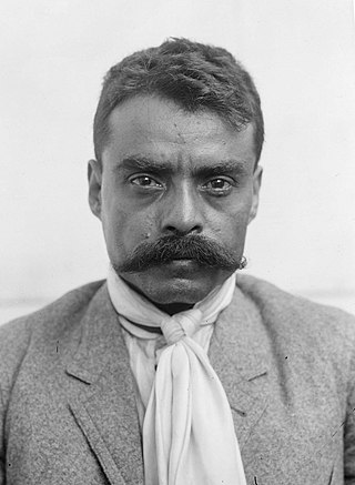
Emiliano Zapata Salazar was a Mexican revolutionary. He was a leading figure in the Mexican Revolution of 1910–1920, the main leader of the people's revolution in the Mexican state of Morelos, and the inspiration of the agrarian movement called Zapatismo.

Morelos, officially the Free and Sovereign State of Morelos, is a landlocked state located in south-central Mexico. It is one of the 32 states which comprise the Federal Entities of Mexico. It is divided into 36 municipalities and its capital city is Cuernavaca.

Puerto Morelos is a municipality, town, and seaport in Quintana Roo, Mexico's easternmost state, on the Yucatán Peninsula. The town is located in the northeast of the state, about 36 km (22 mi) south of the resort city of Cancún, and about 30 km (19 mi) north of the city of Playa del Carmen.
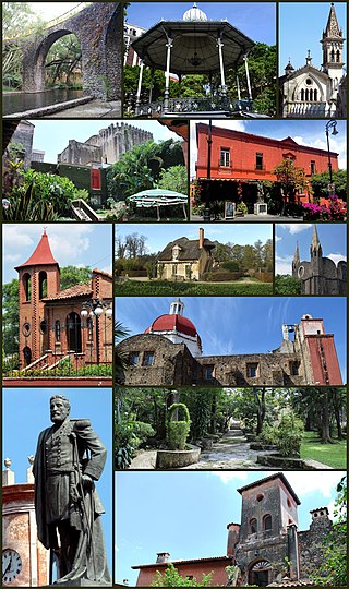
Cuernavaca is the capital and largest city of the state of Morelos in Mexico. Along with Chalcaltzingo, it is likely one of the origins of the Mesoamerican civilization. Olmec works of art, currently displayed in the Museum of Anthropology in Mexico City were found in the Gualupita III archeological site.
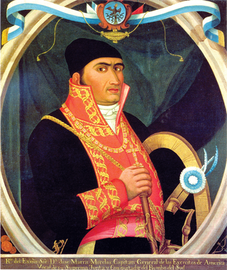
José María Teclo Morelos Pérez y Pavón was a Mexican Catholic priest, statesman and military leader who led the Mexican War of Independence movement, assuming its leadership after the execution of Miguel Hidalgo y Costilla in 1811.

Cuautla, officially La heroica e histórica Cuautla, Morelos or H. H. Cuautla, Morelos, is a city and municipality in the Mexican state of Morelos, about 104 kilometers south of Mexico City. In the 2010 census the city population was 154,358. The municipality covers 153.651 km2 (59.325 sq mi). Cuautla is the third most populous city in the state, after Cuernavaca and Jiutepec. The city was founded on April 4, 1829. The 2020 population figures were 187,118 inhabitants for the municipality and 157,336 inhabitants for the city of Cuatula.
Jojutla is a municipality in the state of Morelos, Mexico. Its municipal seat is the city of Jojutla de Juárez. The name Jojutla comes from Nahuatl Xoxōuhtlān and means, Place of abundant blue skies. Another interpretation is Jojutla should be written Xo-Xoutla and its etymological roots come from: xoxou-ki, and Tla-ntli, (teeth) to indicate abundance, so the name means: Place abundant in blue paint. This meaning is corroborated by Father José Agapito Mateo Minos in Nohualco Tlalpixtican (1722), about how he saw the maceration and decanting tanks of the xoxouki plant, when it still existed in the plaza Zacate. Ángela Peralta mentions a unique pyramid consisting of three parts: the momozok, the turret and the campanile (tower), demolished by the colonial government. Remnants of this can be seen in the staircase of the municipal palace.

Tepoztlán is a town in the central Mexican state of Morelos. It is located at 18°59′07″N99°05′59″W in the heart of the Tepoztlán Valley. The town serves as the seat of government for the municipality of the same name. The town had a population of 14,130 inhabitants, while the municipality reported 41,629 inhabitants in the 2010 national census.
Xochitepec is a municipio (municipality) of the state of Morelos, in central Mexico. Xochitepec is also the name of its principal township and seat of the municipal government. It is located approximately 13 km (8.1 mi) to the south of the capital of Morelos, Cuernavaca, on the southern outskirts of that city's greater metropolitan area.

Zacatepec de Hidalgo is a town in the state of Morelos, Mexico. It is bordered by Puente de Ixtla, Tlaltizapán, Tlaquiltenango and Jojutla. Miguel Hidalgo was the priest whose call to arms on September 16, 1810, led to the Mexican War of Independence.

The Liberation Army of the South was a guerrilla force led for most of its existence by Emiliano Zapata that took part in the Mexican Revolution from 1911 to 1920. During that time, the Zapatistas fought against the national governments of Porfirio Díaz, Francisco Madero, Victoriano Huerta, and Venustiano Carranza. Their goal was rural land reform, specifically reclaiming communal lands stolen by hacendados in the period before the revolution. Although rarely active outside their base in Morelos, they allied with Pancho Villa to support the Conventionists against the Carrancistas. After Villa's defeat, the Zapatistas remained in open rebellion. It was only after Zapata's 1919 assassination and the overthrow of the Carranza government that Zapata's successor, Gildardo Magaña, negotiated peace with President Álvaro Obregón.
The governor of Morelos, which was created with the state of Mexico in 1869.
Wilson David Morelo López, is a Colombian football striker who plays for Categoría Primera A club Independiente Santa Fe.

The Morelos satellites are a series of Mexican communications satellites. The first two operated between 1985 and 1998 and provided telephony, data, and television services over the territory of the Mexican Republic and adjacent areas. The third is now part of the MEXSAT constellation but carries the Morelos name.
Kevin Clancy is a Scottish football referee who has been on the international list of FIFA referees since January 2012 after attending a course at Specsavers Centre of Refereeing Excellence. Clancy has been refereeing since 2000.

Ecatepec, officially Ecatepec de Morelos, is a municipality in the State of Mexico, and is situated in the north part of the Greater Mexico City urban area. The municipal seat is San Cristóbal Ecatepec.

Alfredo José Morelos Aviléz is a Colombian professional footballer who plays as a striker for Categoría Primera A club Atletico Nacional, on loan from Campeonato Brasileiro Série B club Santos.
Morelos is a municipality in the Mexican state of Michoacán. It is located approximately 40 kilometres (25 mi) northwest of the state capital of Morelia.
Carácuaro de Morelos is a town in the Mexican state of Michoacán. It serves as the municipal seat for the surrounding municipality of Carácuaro.


