
The Ohio River is a 981-mile (1,579 km) long river in the United States. It is located in the Midwestern and Southern United States, flowing southwesterly from western Pennsylvania south of Lake Erie to its mouth on the Mississippi River at the southern tip of Illinois. It is the third largest river by discharge volume in the United States and the largest tributary by volume of the north-south flowing Mississippi River that divides the eastern from western United States. The river flows through or along the border of six states, and its drainage basin includes parts of 14 states. Through its largest tributary, the Tennessee River, the basin includes several states of the southeastern U.S. It is the source of drinking water for three million people.

The National Road was the first major improved highway in the United States built by the federal government. Built between 1811 and 1837, the 620-mile (1,000 km) road connected the Potomac and Ohio Rivers and was a main transport path to the West for thousands of settlers. When improved in the 1830s, it became the second U.S. road surfaced with the macadam process pioneered by Scotsman John Loudon McAdam.

Huntington is a city in Cabell and Wayne Counties in the U.S. state of West Virginia. It is the county seat of Cabell County, and largest city in the Huntington-Ashland, WV-KY-OH Metropolitan Statistical Area, sometimes referred to as the Tri-State Area. A historic and bustling city of commerce and heavy industry, Huntington has benefited from its location on the Ohio River at the mouth of the Guyandotte River. It is home to the Port of Huntington Tri-State, the second-busiest inland port in the United States.

Wheeling is a city in Ohio and Marshall counties in the U.S. state of West Virginia. Located almost entirely in Ohio County, of which it is the county seat, it lies along the Ohio River in the foothills of the Appalachian Mountains. Wheeling was originally a settlement in the British colony of Virginia, and later the second largest city in the Commonwealth of Virginia. Wheeling was where creation of West Virginia was planned, and it was the first capital of the new state. Due to its location along major transportation routes, including the Ohio River, National Road, and the B&O Railroad, Wheeling became a manufacturing center in the late nineteenth century. After experiencing the closing of factories and substantial population loss following World War II, Wheeling's major industries now include healthcare, education, law and legal services, entertainment and tourism, and energy.

The Monongahela River —often referred to locally as the Mon —is a 130-mile-long (210 km) river on the Allegheny Plateau in north-central West Virginia and southwestern Pennsylvania. The river flows from the confluence of its west and east forks in north-central West Virginia northeasterly into southwestern Pennsylvania, then northerly to Pittsburgh and its confluence with the Allegheny River to form the Ohio River. The river's entire length is navigable via a series of locks and dams.

The Teays River (pronounced taze) was a major preglacial river that drained much of the present Ohio River watershed, but took a more northerly downstream course. Traces of the Teays across northern Ohio and Indiana are represented by a network of river valleys. The largest still existing contributor to the former Teays River is the Kanawha River in West Virginia, which is itself an extension of the New River. The name Teays from the Teays Valley is associated with this buried valley since 1910. The more appropriate name would be ancestral Kanawha Valley. The term Teays is used when discussing the buried portion of the ancestral Kanawha River. The Teays was comparable in size to the Ohio River. The River's headwaters were near Blowing Rock, North Carolina; it then flowed through Virginia, West Virginia, Ohio, Indiana and Illinois.. The largest tributary to the Teays River was the Old Kentucky River, which extended from southern Kentucky through Frankfort and subsequently flowed northeast, meeting other tributaries and eventually joining the Teays.

The Little Kanawha River is a tributary of the Ohio River, 169 mi (269 km) long, in western West Virginia in the United States. Via the Ohio, it is part of the watershed of the Mississippi River, draining an area of 2,320 mi² (6,009 km²) on the unglaciated portion of the Allegheny Plateau. It served as an important commercial water route in the early history of West Virginia, particularly in the logging and petroleum industries.

Gallipolis Ferry is a census-designated place (CDP) in Mason County, West Virginia, USA. It is situated on the Ohio River along West Virginia Route 2. As of the 2010 census, its population was 817. It is the site of the Robert C. Byrd Locks & Dam on the Ohio. The community was named for the fact a ferry once provided service between the town site and nearby Gallipolis, Ohio.

The Ohio River Islands National Wildlife Refuge (ORINWR) is a National Wildlife Refuge (NWR) in non-contiguous sites consisting of islands along 392 miles (631 km) of the Ohio River, primarily in the U.S. state of West Virginia. There are also two islands upstream in Beaver County, Pennsylvania, and a pair downstream in Lewis County, Kentucky. Going downstream, the refuge is currently located in parts of these counties: Beaver, Brooke, Ohio, Marshall, Wetzel, Tyler, Pleasants, Wood, Jackson, Mason, and Lewis. All counties are in West Virginia, with the exceptions in Pennsylvania and Kentucky mentioned above. The ORINWR was established in 1990 and consists of 3,354 acres (13.57 km2) of land and underwater habitat on 22 islands and four mainland properties. The refuge headquarters and visitor center is located in Williamstown, West Virginia. Prior to its establishment, West Virginia was the only state of the United States without a NWR.
The Huntington–Ashland metropolitan area is a metropolitan area in the Appalachian Plateau region of the United States. Referred to locally as the “Tri-State area”, the region spans seven counties in the three states of West Virginia, Kentucky, and Ohio. With a population of 361,580, the Tri-State area is nestled along the banks of the Ohio River. The region offers a diverse range of outdoor activities.
Waverly is a census-designated place (CDP) in northeastern Wood County, West Virginia, United States. As of the 2010 census, its population was 395. It lies along the Ohio River on West Virginia Route 2, northeast of the city of Parkersburg, the county seat of Wood County. Its elevation is 620 feet (189 m). Although it is unincorporated, it has a post office, with the ZIP code of 26184 and a school.
Proctor is an unincorporated community in northwestern Wetzel County, West Virginia, United States. It lies on West Virginia Route 2 along the Ohio River, north of the city of New Martinsville, the county seat of Wetzel County. Its elevation is 630 feet (192 m). Because the community has borne multiple names, the Board on Geographic Names officially designated it "Proctor" in 1980. Although it is unincorporated, it has a post office, with the ZIP code of 26055.
Sherman is an unincorporated community in northern Jackson County, West Virginia, United States, along the Ohio River. It lies along West Virginia Route 68 north of the city of Ravenswood. Its elevation is 600 feet (183 m).
Clifton is an unincorporated community in Mason County, West Virginia, United States. Clifton is located on the east bank of the Ohio River along West Virginia Route 62, 1.5 miles (2.4 km) south of Mason; Middleport, Ohio lies across the river. Clifton had a post office, which closed on May 24, 1997.

Pottery Addition is a census-designated place (CDP) in Jefferson County, Ohio, United States. Its population was 293 as of the 2010 census. The community is located along the Ohio River and is served by Ohio State Route 7.

Graham Magisterial District is one of ten magisterial districts in Mason County, West Virginia. The district was originally established as a civil township in 1863, and converted into a magisterial district in 1872. In 2010, Graham District was home to 2,756 people.

Waggener Magisterial District is one of ten magisterial districts in Mason County, West Virginia. The district was originally established as a civil township in 1863, and converted into a magisterial district in 1872. In 2010, Waggener District was home to 2,720 people.

Cooper Magisterial District is one of ten magisterial districts in Mason County, West Virginia. The district was originally established as a civil township in 1863, and converted into a magisterial district in 1872. In 2010, Cooper District was home to 1,874 people.
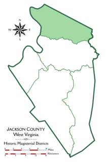
Grant District, formerly Grant Magisterial District, is one of five historic magisterial districts in Jackson County, West Virginia. The district was originally established as a civil township in 1863, and converted into a magisterial district in 1872. When Jackson County was redistricted in the 1990s, the area of Grant District was included in the new Northern Magisterial District. However, the county's historic magisterial districts continue to exist in the form of tax districts, serving all of their former administrative functions except for the election of county officials.

Union District, formerly Union Magisterial District, is one of five historic magisterial districts in Jackson County, West Virginia. The district was originally known as Hushan's Mills Township, one of five civil townships established in 1863, at the height of the Civil War; it was subsequently given the patriotic name of Union Township. In 1872, West Virginia's townships were converted into magisterial districts. When Jackson County was redistricted in the 1990s, the area of Union District was included in the new Western Magisterial District. However, the county's historic magisterial districts continue to exist in the form of tax districts, serving all of their former administrative functions except for the election of county officials.


