
West Virginia is a state in the Appalachian, Mid-Atlantic and Southeastern regions of the United States. It is bordered by Pennsylvania to the northeast, Maryland to the east and northeast, Virginia to the southeast, Kentucky to the southwest, and Ohio to the northwest. West Virginia is the 41st-largest state by area and ranks 38th in population, with around 1.792 million residents. The capital and largest city is Charleston.

Walthamstow is a large town in east London, England, located in the historic county of Essex.

Mitcham Junction is a National Rail station served by Southern and Thameslink trains, and a Tramlink stop. It is in the London Borough of Merton and is in Travelcard Zone 4.
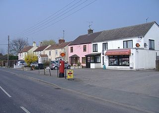
Easter Compton is a village in the civil parish of Almondsbury, South Gloucestershire, England. It is situated at the bottom of a hill near Junction 17 of the M5 Motorway on the B4055 road.

Blackhorse Road is a joint London Overground and London Underground station, located at the junction of Blackhorse Road/Blackhorse Lane with Forest Road in the Walthamstow neighbourhood of the London Borough of Waltham Forest, London, England. It is on the Victoria line of the London Underground and is the penultimate station on the eastern end of that line. Above ground, the station is on the Gospel Oak to Barking line of the London Overground, 7 miles 21 chains (11.7 km) from St Pancras.

The 11th Armored Cavalry Regiment is a unit of the United States Army garrisoned at Fort Irwin, California. Although termed an armored cavalry regiment, it is being re-organized as a multi-component heavy brigade combat team. The regiment has served in the Philippine–American War, World War II, the Vietnam War, Cold War, Operation Desert Storm, and Operation Iraqi Freedom. The 11th ACR serves as the Opposing Force (OPFOR) for the Army and Marine task forces, and foreign military forces that train at the National Training Center.
Ravenna Township is one of the eighteen civil townships of Portage County, Ohio, United States. The 2000 census found 9,270 people in the township.

Emersons Green is a suburb of Bristol and parish in the unitary authority of South Gloucestershire. Sitting 7 miles north of Bristol, England. It was developed from farming land during the 1990s and early 21st century, and sits within the historic parish of Mangotsfield.

Buffalo Dreams is a 2005 Disney Channel Original Movie directed by David Jackson.
Addiscombe Railway Park, also known as the Addiscombe Linear Park, is a 3.3 acres (1.3 ha) park in Addiscombe, South London, managed by the London Borough of Croydon.

The R730 road is a regional road in County Wexford, Ireland. From its junction with the R702 in Kiltealy it takes a southeasterly route to its junction with the R741 in the centre of Wexford Town, continuing south to Blackhorse to its junction on a roundabout with the N25 Wexford bypass.
A black horse is an equine coat color.

Blackhorse Quarry is a 0.2-hectare (0.49-acre) geological Site of Special Scientific Interest south-east of Battle in East Sussex. It is a Geological Conservation Review site.
Operation Atlanta was a road security operation in Đồng Nai Province carried out by the 11th Armored Cavalry Regiment from 19 October to December 1966 during the Vietnam War and was the first major combat operation of the 11th ACR in the war.

The R806 road is a regional road in Dublin, Ireland.
Amanda Blackhorse is a social worker and member of the Navajo people who is known for her work as an activist on the Washington Redskins name controversy. She is the lead plaintiff in Blackhorse v. Pro-Football, Inc.
Frank Blackhorse is one of several aliases used by a member of the American Indian Movement. He is perhaps best known for his participation in the Wounded Knee incident, particularly his role in the shootout that left two FBI and one American Indian dead and for becoming a fugitive on the run who fled to Canada shortly after.

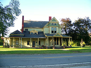
Black Horse, also spelled Blackhorse, is an unincorporated community in Portage County, Ohio, United States, located in western Ravenna Township. It is centered along Ohio State Route 59 at its intersection with Brady Lake Road, just west of the city limits of Ravenna. The community takes its name from the Black Horse Tavern, which was located on the north side of modern-day State Route 59 for much of the 19th century.
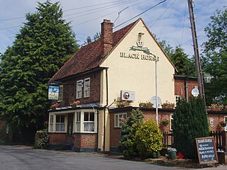
The Black Horse is a Grade II listed public house at 65 Blackhorse Lane in South Mimms, Hertfordshire, England. It dates from the early 18th century and is of red brick with a tiled roof. Blackhorse Lane, which may be named after the pub, was the lane along which South Mimms developed. In 1847, a police station was built there, with married quarters added in 1908, but the surrounding areas was and remains rural.

Blackhorse is a stop on the Luas light-rail tram system in Dublin, Ireland. It opened in 2004 as a stop on the Red Line. The stop is located at the intersection of Davitt Road and Naas Road. The stop has two edge platforms, and is of the same design as many Luas stops. After departing the stop, northbound trams head along a section of track which runs adjacent to the Grand Canal on their way to Connolly or The Point. Southbound trams turn onto Naas Road, travelling south-west towards Tallaght or Saggart.


