Marr is one of six committee areas in Aberdeenshire, Scotland. It has a population of 34,038. Someone from Marr is called a Màrnach in Scottish Gaelic.

Grampian was a local government region of Scotland from 1975 to 1996. It is now divided into the unitary council areas of:

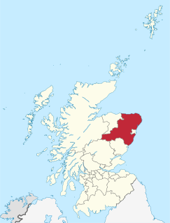
West Aberdeenshire and Kincardine is a county constituency of the House of Commons of the Parliament of the United Kingdom of Great Britain and Northern Ireland (Westminster), which elects one Member of Parliament (MP) by the first past the post system of election. It was first used in the 1997 general election, but has undergone boundary changes since that date.

The A944 road connects Aberdeen with Strathdon in north-east Scotland.

Garioch is one of six committee areas in Aberdeenshire, Scotland. It has a population of 46,254, which gives it the largest population of Aberdeenshire's six committee areas. 'The Rough Howe' from the Scots Gaelic Garbh - rough; iochd - howe. The Garioch consists primarily of the district drained by the River Ury and its tributaries the Shevock and the Gadie Burn.

Towie is a small hamlet in Aberdeenshire, Scotland, close to Alford and Lumsden, on the River Don.

Maud is a small town in the Buchan area of the Scottish county of Aberdeenshire. Population 780. Located 13 miles west of Peterhead on the South Ugie Water, Maud rose to prosperity in the nineteenth century as a railway junction of the Formartine and Buchan Railway that ran through Maud to Fraserburgh and Peterhead, but has always been the meeting place of six roads. It has had a variety of names:
Brideswell is a village in Aberdeenshire, Scotland. It is named in honour of Brigid of Ireland.

The Formartine and Buchan Way is a long-distance footpath in Scotland, extending from Dyce north to Peterhead and Fraserburgh in the Buchan and Formartine districts of Aberdeenshire in Scotland. It follows the track of a former railway line, the Formartine and Buchan Railway, and is open to walkers, cyclists and horse riders. The railway closed in 1979 (Fraserburgh) and 1970 (Maud-Peterhead). The walkway opened in the early 1990s, and is managed by Aberdeenshire Council. It is listed as one of Scotland's Great Trails by Scottish Natural Heritage. Places of interest along the way include Drinnes Wood Observatory, Strichen Stone Circle, Aden Country Park, Deer Abbey and The White Horse at Strichen.

Aden Country Park is located in Mintlaw, Aberdeenshire, Scotland. The park has a caravan area with camping, a small shop, a small cafe near the agricultural museum, a play area, the maintained ruins of Aden House, landscaped gardens, and a barbecue area. Aden Park can be accessed from Mintlaw by Station Road or Nether Aden Road.

Garlogie is a roadside hamlet in Aberdeenshire, Scotland. It was, during the 19th century, the site of a textile milling settlement using water from Loch of Skene. The mill is now a museum. Garlogie also has an inn. To the southwest, there is a gas compression and odourisation station which forms part of the National Gas Network.
Morven is a Corbett in Aberdeenshire, Scotland. It is 871 m (2858 ft) high.

Tullich is a village in Aberdeenshire, Scotland. It is known as the birthplace of St. Nathalan and also as the site of some noted Pictish stones.

Sandhaven is a small fishing village in Aberdeenshire, Scotland that lies between Rosehearty and Fraserburgh. It is joined to the West to the even smaller village of Pitullie.

Gartly is an inland hamlet in Aberdeenshire, Scotland. It is several miles south of the town of Huntly, and sits on the River Bogie, a tributary of the River Deveron. The parish in which it is located also takes its name.
Glen Garioch distillery is one of the oldest whisky distilleries in Scotland, dating back to 1797.
Kirkton of Tough, usually shortened to Tough, is a settlement in the Marr area of Aberdeenshire, Scotland at grid reference NJ615129. It is about 4 kilometres (2.5 mi) southeast of Alford and 143 kilometres (89 mi) from Edinburgh. Tough is where the Aberdeen Angus breed of cattle was first bred.

Castle Forbes is a 19th-century country house in the Scottish baronial architecture style near Alford in Aberdeenshire, Scotland.
Clatt, is a village in Aberdeenshire, Scotland.
Yonder Bognie is a stone circle in Aberdeenshire, Scotland. It is located in an agricultural field under private ownership and is a scheduled ancient monument.