Fraserburgh, locally known as the Broch, is a town in Aberdeenshire, Scotland, with a population recorded in the 2011 Census as 13,100. It lies in Buchan in the northeastern corner of the county, about 40 miles (64 km) north of Aberdeen and 17 miles (27 km) north of Peterhead. It is the biggest shellfish port in Scotland and one of the largest in Europe, landing over 5,450 tonnes in 2016. Fraserburgh is also a major port for white and pelagic fish.

Alford is a market town and civil parish in the East Lindsey district of Lincolnshire, England, at the foot of the Lincolnshire Wolds, which form an Area of Outstanding Natural Beauty. The population was recorded as 3,459 in the 2011 Census and estimated at 3,830 in 2021. It lies between the towns of Mablethorpe, Louth, Spilsby, and Skegness and acts as a local retail centre.

Inverurie is a town in Aberdeenshire, Scotland at the confluence of the rivers Ury and Don, about 16 miles (26 km) north-west of Aberdeen.

Fettercairn is a small village in Aberdeenshire, Scotland, northwest of Laurencekirk in Aberdeenshire on the B966 from Edzell. Fettercairn is also reached via the Cairn O' Mount road (B974) from Deeside.

Kemnay is a village 16 miles (26 km) west of Aberdeen in Garioch, Aberdeenshire, Scotland.

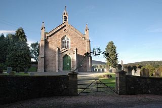
Aberdalgie is a small village in the Scottish council area of Perth and Kinross. It is 3 miles southwest of Perth, and lies between the B9112 road, to the north, and the River Earn, to the south. Milltown Burn and Cotton Burn streams meet in the village centre, The village contains Aberdalgie Parish Church, the present building of which dates to 1773. The historic Dupplin Castle is 1+1⁄2 miles east of the village.
WestAberdeenshire was a Scottish county constituency of the House of Commons of the Parliament of the United Kingdom from 1868 to 1918 and from 1950 to 1983. It elected one Member of Parliament (MP) by the first past the post system of election.
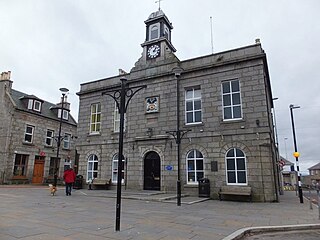
Oldmeldrum is a village and parish in the Formartine area of Aberdeenshire, not far from Inverurie in North East Scotland. With a population of around 2,187, Oldmeldrum falls within Scotland's top 300 centres of population. Oldmeldrum is home to one of the oldest whisky distilleries in Scotland, Glen Garioch, which was built in 1797. Local industries are agriculture and engineering services connected to the oil industry in Aberdeen.

A mortsafe or mortcage was a construction designed to protect graves from disturbance, used in the United Kingdom. Resurrectionists had supplied schools of anatomy since the early 18th century. This was due to the necessity for medical students to learn anatomy by attending dissections of human subjects, which was frustrated by the very limited allowance of dead bodies – for example the corpses of executed criminals – granted by the government, which controlled the supply.

St Cyrus or Saint Cyrus, formerly Ecclesgreig is a village in the far south of Aberdeenshire, Scotland.
Blaikie is a Scottish surname.

Clan Strachan is a Scottish clan originating from the barony of Strachan, in Aberdeenshire. The clan does not have a chief, therefore it is considered by Court of the Lord Lyon and the Stand Council of Scottish Chiefs as an Armigerous clan.

Longside is a village located in Aberdeenshire, Scotland, consisting of a single main street. It lies seven miles inland from Peterhead and two miles from Mintlaw on the A950. Its population in 2001 was 721. The River Ugie flows through it.

Cuminestown is a village in the Formartine area of Aberdeenshire, Scotland, and sits at the centre of the parish of Monquhitter. It is approximately 6 miles from Turriff and New Deer, 10 miles from Macduff and Banff and 15 miles from Fraserburgh.

Auchenblae is a village in the Kincardine and Mearns area of Aberdeenshire, formerly in Kincardineshire, Scotland. The village was known for its weavers, a whisky distillery and the annual Paldie's Fair horse market.

Auchleven is a village in Aberdeenshire, Scotland. Located approximately 4 miles south of Insch, 17 mi (27 km) south of Huntly and 12 mi (19 km) north-west of Inverurie.

Ollaberry is a village on Mainland, Shetland, Scotland on the west shore of Yell Sound, 10.9 miles (17.5 km) north by road from Brae. Ollaberry Churchyard contains a Listed B monument, sculpted by John Forbes in 1754. Ollaberry Primary School was established in 1873.
Keig is a village within the local government area of Aberdeenshire Council in the North East of Scotland and is located within the Marr area of Aberdeenshire three miles from Alford. It lies on the B992 road between Insch and the village of Whitehouse.

St Mary Magdalen Roman Catholic Church, Mortlake, is a Roman Catholic church in North Worple Way, Mortlake, in the London Borough of Richmond upon Thames. The church is dedicated to Jesus' companion Mary Magdalene. It is located just south of Mortlake High Street and the Anglican St Mary the Virgin Church. St Mary Magdalen's Catholic Primary School is just north of the churchyard.
Kennethmont is a village in the Marr area of Aberdeenshire, Scotland, approximately 8 miles (13 km) south of Huntly.