| Mount Birdwood | |
|---|---|
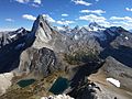
 Mt. Birdwood from Burstall pass | |
| Highest point | |
| Elevation | 3,097 m (10,161 ft) [1] [2] |
| Prominence | 735 m (2,411 ft) [1] |
| Listing | Mountains of Alberta |
| Coordinates | 50°47′07″N115°22′05″W / 50.78528°N 115.36806°W [3] |
| Geography | |
 Mount Birdwood Location in Alberta  Mount Birdwood Location in Canada | |
| Country | Canada |
| Province | Alberta |
| Parent range | Spray Mountains [4] Canadian Rockies |
| Topo map | NTS 82J14 Spray Lakes Reservoir [3] |
| Climbing | |
| First ascent | 1922 by C.F. Hogeboom, F.N. Waterman, Rudolph Aemmer. |
Mount Birdwood is a 3,097-metre (10,161-foot) summit in the Spray Mountains range of the Canadian Rockies in Alberta, Canada. [3] The mountain is situated on the east boundary of Banff National Park in the upper Spray Lakes River Valley.