Mount Houghton

Last updated
Mount Houghton
Mount Houghton.jpg
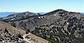
Northeast aspect, from Mt. Rose
Highest point
Elevation 10,490 ft (3,200 m) [1] [2]
Prominence 759 ft (231 m) [3]
Parent peak Mount Rose (10,776 ft) [4]
Isolation 1.34 mi (2.16 km) [4]
Coordinates 39°20′03″N119°56′22″W / 39.3340688°N 119.9393656°W / 39.3340688; -119.9393656 [5]
Naming
Etymology John G. Houghton
Geography
Relief map of U.S., Nevada.png
Red triangle with thick white border.svg
Mount Houghton
Location in Nevada
Usa edcp relief location map.png
Red triangle with thick white border.svg
Mount Houghton
Mount Houghton (the United States)
Location Mount Rose Wilderness
Country United States of America
State Nevada
County Washoe
Parent range Sierra Nevada
Carson Range
Topo map USGS Mount Rose
Climbing
Easiest route class 1 hiking [4]

Mount Houghton is a 10,490-foot-elevation mountain summit located in Washoe County, Nevada, United States.

Contents

Description

Mount Houghton is set seven miles north of Lake Tahoe in the Mount Rose Wilderness, on land managed by the Humboldt-Toiyabe National Forest. It is the highest point of Relay Ridge, second-highest peak within the wilderness, and ranks as the seventh-highest peak of the Carson Range, [3] which is a subset of the Sierra Nevada. It is situated 1.4 miles (2.3 km) north of Relay Peak, 1.4 miles (2.3 km) southwest of line parent Mount Rose and six miles (9.7 km) north of Incline Village. Topographic relief is significant as the west aspect rises 2,000 feet (610 meters) above Gray Creek in one mile. The Tahoe Rim Trail traverses the southern base of the peak, providing an approach option.

Etymology

This landform's toponym was officially adopted in 1988 by the U.S. Board on Geographic Names to remember Dr. John Greenleaf Houghton (1940–1979), professor of geography at the University of Nevada, Reno. [5] He was one of 257 people who perished November 29, 1979, when Air New Zealand Flight 901 flew into Mount Erebus on Ross Island, Antarctica, killing all 237 passengers and 20 crew on board. [6]

Climate

According to the Köppen climate classification system, Mount Houghton is located in an alpine climate zone. [7] Most weather fronts originate in the Pacific Ocean, and travel east toward the Sierra Nevada mountains. As fronts approach, they are forced upward by the peaks (orographic lift), causing them to drop their moisture in the form of rain or snowfall onto the range. Most of the snow in Nevada falls from December through March. [8]

See also

Related Research Articles

<span class="mw-page-title-main">Mount Tallac</span> Mountain peak southwest of Lake Tahoe, El Dorado county in California, U.S.A.

Mount Tallac is a mountain peak southwest of Lake Tahoe, in El Dorado County, California. The peak lies within the Desolation Wilderness in the Eldorado National Forest. It is quite visible from State Routes 89 and 28, and U.S. Route 50. A "cross of snow" is clearly visible on the mountain's face during the winter, spring, and early summer months.

<span class="mw-page-title-main">Mount Rose (Nevada)</span> Mountain in the United States

Mount Rose is the highest mountain in Washoe County, within the Carson Range of Nevada, United States. It ranks thirty-seventh among the most topographically prominent peaks in the state. It is also both the highest and most topographically prominent peak of the greater Sierra Nevada range within the state of Nevada, and the third most topographically prominent peak in the Sierra Nevada overall. It is located in the Mount Rose Wilderness of the Humboldt-Toiyabe National Forest. An extinct volcano, the mountain is in between Lake Tahoe and Reno. State Route 431 traverses Mount Rose Summit southeast of Mount Rose. Due to the high elevation, most of the precipitation that falls on the mountain is snow. The view from Mount Rose, facing east is the Truckee Meadows area is the second largest population center in Nevada.

<span class="mw-page-title-main">Mount Corcoran</span> Mountain summit of the Sierra Nevada mountain range in California

Mount Corcoran is a 13,701-foot (4,176 m) mountain summit located on the crest of the Sierra Nevada mountain range in California. It is situated on the boundary between Tulare County and Inyo County, as well as the boundary between Sequoia National Park and John Muir Wilderness. It is 12 miles (19 km) west-southwest of the community of Lone Pine, 3.6 miles (5.8 km) southeast of Mount Whitney, 1.2 miles (1.9 km) northwest of Mount Langley, and 0.23 miles (0.37 km) immediately south of Mount Le Conte, the nearest higher neighbor. Topographic relief is significant as it rises approximately 1,800 feet above Iridescent Lake in one-half mile.

<span class="mw-page-title-main">Cirque Peak (California)</span> Mountain summit in California

Cirque Peak is a 12,900-foot-elevation (3,900-meter) mountain summit located on the crest of the Sierra Nevada mountain range in California. It is situated on the common border of Tulare County with Inyo County, as well as the shared boundary of Golden Trout Wilderness and John Muir Wilderness, on land managed by Inyo National Forest. It is 14 miles (23 km) southwest of the community of Lone Pine, 7.7 miles (12.4 km) south-southeast of Mount Whitney, and 3.2 miles (5.1 km) south of Mount Langley, the nearest higher neighbor. Cirque Peak is the highest point of the Golden Trout Wilderness, and ranks as the 175th highest peak in California. Topographic relief is significant as it rises 1,800 feet above Cirque Lake in approximately one mile. The Pacific Crest Trail traverses the southwest slope of this mountain, providing an approach option. The mountain was apparently named in 1890 by Joseph Nisbet LeConte and companions who noted the remarkable cirque on the north aspect.

<span class="mw-page-title-main">Mount Baldwin (California)</span> Mountain in the state of California

Mount Baldwin is a 12,614-foot-elevation (3,845-meter) mountain summit located in the Sierra Nevada mountain range in Mono County of northern California, United States. It is situated in the John Muir Wilderness on land managed by Inyo National Forest. It is four miles north of Red and White Mountain, and approximately 10.5 miles (16.9 km) southeast of the community of Mammoth Lakes. The nearest higher neighbor is Red Slate Mountain, 2 miles (3.2 km) to the south-southwest. Baldwin ranks as the 257th highest summit in California. Topographic relief is significant as the east aspect rises 3,775 feet above McGee Canyon in 1.5 mile. The first ascent of the summit was made July 2, 1928, by Norman Clyde, who is credited with 130 first ascents, most of which were in the Sierra Nevada.

<span class="mw-page-title-main">Mount Johnson (California)</span> Mountain in the state of California

Mount Johnson is a 12,871-foot-elevation mountain summit located on the crest of the Sierra Nevada mountain range in California, United States. It is situated on the boundary between Kings Canyon National Park and John Muir Wilderness, and along the county line between Fresno County and Inyo County. It is also 18 miles (29 km) west of the community of Big Pine, 0.9 miles (1.4 km) southeast of Mount Gilbert, and one mile (1.6 km) west-northwest of Mount Goode. Mount Johnson ranks as the 187th-highest summit in California. Topographic relief is significant as the southwest aspect rises 3,670 feet above LeConte Canyon in 1.5 mile, and the north aspect rises 3,100 feet above South Lake in 2.5 miles.

<span class="mw-page-title-main">Tunnabora Peak</span> Mountain in California

Tunnabora Peak is a 13,563-foot-elevation (4,134-meter) mountain summit located on the crest of the Sierra Nevada mountain range in California. It is situated on the common border of Tulare County with Inyo County, as well as the shared boundary of Sequoia National Park and John Muir Wilderness. It is set above the north shore of Tulainyo Lake, 13 miles (21 km) west of the community of Lone Pine, 1.86 miles (2.99 km) north-northeast of Mount Whitney, and 0.9 miles (1.4 km) north-northwest of Mount Carillon. Tunnabora ranks as the 51st-highest peak in California. Topographic relief is significant as it rises approximately 5,200 feet above Whitney Portal in approximately three miles.

<span class="mw-page-title-main">Mount Izaak Walton</span> Mountain in the state of California

Mount Izaak Walton is a 12,077-foot-elevation (3,681 meter) mountain summit located in the Sierra Nevada mountain range in Fresno County of northern California, United States. It is situated in the John Muir Wilderness, on land managed by Sierra National Forest. Mount Izaak Walton ranks as the 404th-highest summit in California. Topographic relief is significant as the northwest aspect rises 1,800 feet above Izaak Walton Lake in approximately one mile. It is six miles northeast of Lake Thomas A Edison, and approximately 14 miles (23 km) south-southeast of the community of Mammoth Lakes. The peak is set on Silver Divide, so precipitation runoff from the north side of this mountain drains into Fish Creek which is a tributary of the San Joaquin River, and from the south slope to Mono Creek, also a tributary of the San Joaquin.

<span class="mw-page-title-main">Pilot Knob (Fresno County, California)</span> Mountain in the state of California

Pilot Knob is a 12,245-foot-elevation (3,732 meter) mountain summit located in Fresno County in the Sierra Nevada mountain range in northern California, United States. It is situated at the intersection of Piute Canyon and French Canyon, in the John Muir Wilderness, on land managed by Sierra National Forest. It is set 2.5 miles (4.0 km) south of Merriam Peak and three miles north of the Matthes Glaciers. Pilot Knob is the 360th-highest peak in California, and topographic relief is significant as the west aspect rises 2,800 feet above Hutchinson Meadow in approximately one mile. This mountain was likely named by the USGS during the 1907–09 survey for the Mt. Goddard Quadrangle, and the toponym has been officially adopted by the U.S. Board on Geographic Names.

<span class="mw-page-title-main">Muriel Peak</span> Mountain in the state of California

Muriel Peak is a 12,937-foot-elevation (3,943 meter) double summit mountain located in the Sierra Nevada mountain range in Fresno County, California, United States. The true summit is set within the John Muir Wilderness on land managed by Sierra National Forest, whereas the slightly lower south summit is on the boundary shared with Kings Canyon National Park. It is situated one mile northeast of Mount Goethe and one mile south of Muriel Lake. Muriel Peak is the 167th-highest peak in California, and topographic relief is significant as the summit rises 1,600 feet above Muriel Lake.

<span class="mw-page-title-main">Pyramid Peak (Fresno County, California)</span> Mountain in the American state of California

Pyramid Peak is a 12,779-foot-elevation (3,895 meter) mountain summit located west of the crest of the Sierra Nevada mountain range, in Fresno County, California, United States. It is situated in Kings Canyon National Park, 2.2 miles (3.5 km) southwest of line parent Mount Ickes and 2.2 miles (3.5 km) southeast of Arrow Peak, which is the nearest higher neighbor. Other nearby peaks include Crater Mountain 2.5 miles (4.0 km) to the northeast, and Window Peak one mile to the south. Pyramid Peak ranks as the 214th-highest summit in California, and topographic relief is significant as the southwest aspect rises over 2,300 feet in approximately one mile.

<span class="mw-page-title-main">Mount Bolton Brown</span> Mountain in the state of California

Mount Bolton Brown is a 13,491-foot-elevation (4,112 meter) mountain summit located on the shared border of Fresno County and Inyo County in California, United States.

<span class="mw-page-title-main">Dicks Peak</span> Mountain in the state of California

Dicks Peak is a 9,974-foot-elevation (3,040 meter) mountain summit located in the Sierra Nevada mountain range in El Dorado County, California, United States. It is the third-highest peak in the Desolation Wilderness, and is set on land managed by Eldorado National Forest. It is situated six miles (9.7 km) south of Lake Tahoe, and approximately eight miles (13 km) west of the community of South Lake Tahoe. Topographic relief is significant as the west aspect rises over 2,300 feet above Rockbound Valley in approximately one mile. One-half mile east of the peak the Pacific Crest Trail and Tahoe Rim Trail traverse Dicks Pass, which provides an approach option for those climbing the peak. Inclusion on the Sierra Peaks Section peakbagging list generates climbing interest.

<span class="mw-page-title-main">Jakes Peak</span> Mountain in the state of California

Jakes Peak is a 9,187-foot-elevation (2,800-meter) mountain summit located in the Sierra Nevada mountain range in El Dorado County, California, United States. It is set within the Desolation Wilderness, on land managed by Eldorado National Forest. This iconic peak is situated above the southwest shore of Lake Tahoe, and approximately seven miles (11 km) northwest of the community of South Lake Tahoe. Topographic relief is significant as the east aspect rises 2,950 feet above the lake in 1.5 miles (2.4 km).

<span class="mw-page-title-main">Mount Reinstein</span> Mountain in California, United States of America

Mount Reinstein is a 12,586-foot-elevation (3,836 meter) mountain summit located west of the crest of the Sierra Nevada mountain range, in Fresno County, California, United States. This peak is situated on the common boundary shared by Kings Canyon National Park with John Muir Wilderness, and it is the highest point on LeConte Divide. Reinstein ranks as the 260th-highest summit in California. It is set 2.7 miles (4.3 km) west of Scylla and 2.0 miles (3.2 km) southwest of Mount Goddard. Topographic relief is significant as the summit rises nearly 1,600 feet above Martha Lake in less than one mile. An ascent of the peak is non-technical, and inclusion on the Sierra Peaks Section peakbagging list generates climbing interest in this remote peak.

<span class="mw-page-title-main">Tinker Knob</span> Mountain in the state of California

Tinker Knob is an 8,949-foot-elevation (2,728 meter) mountain summit in Placer County, California, United States.

<span class="mw-page-title-main">Aperture Peak</span> Mountain in the state of California

Aperture Peak is a 13,265-foot-elevation mountain summit located in Inyo County, California, United States.

<span class="mw-page-title-main">Relay Peak</span> Mountain in the American state of Nevada

Relay Peak is a 10,338-foot-elevation mountain summit located in Washoe County, Nevada, United States.

<span class="mw-page-title-main">Tamarack Peak</span> Mountain in the American state of Nevada

Tamarack Peak is a 9,897-foot-elevation mountain summit located in Washoe County, Nevada, United States.

<span class="mw-page-title-main">Rose Knob Peak</span> Mountain in the American state of Nevada

Rose Knob Peak is a 9,710-foot-elevation mountain summit located in Washoe County, Nevada, United States.

References

  1. United States Board on Geographic Names (1988), Decisions on Geographic Names in the United States, List 8803, Department of the Interior, p. 9
  2. United States Geological Survey topographical map - Mount Rose
  3. 1 2 "Mount Houghton, Nevada". Peakbagger.com. Retrieved 2022-07-23.
  4. 1 2 3 "Houghton, Mount - 10,490' NV". listsofjohn.com. Retrieved 2022-07-23.
  5. 1 2 "Mount Houghton". Geographic Names Information System . United States Geological Survey, United States Department of the Interior . Retrieved 2022-07-23.
  6. John Houghton, otago.ac.nz
  7. "Climate of the Sierra Nevada". Encyclopædia Britannica .
  8. John G. Houghton (1975), Nevada's Weather and Climate, Nevada Bureau of Mines and Geology, University of Nevada, p. 53