Mount Lawlor

Last updated

Mount Lawlor
Josephine Peak Summit Views - Mount Lawlor.jpg
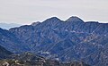
West aspect, viewed from Josephine Peak
Highest point
Elevation 5,961 ft (1,817 m) [1]
Prominence 745 ft (227 m) [1]
Parent peak Strawberry Peak (6,164 ft) [2]
Isolation 1.30 mi (2.09 km) [2]
Listing Hundred Peaks Section [3]
Coordinates 34°16′14″N118°06′14″W / 34.2705822°N 118.1039256°W / 34.2705822; -118.1039256 [4]
Naming
Etymology Oscar Lawler [5]
Geography
Relief map of California.png
Red triangle with thick white border.svg
Mount Lawlor
Location in California
Usa edcp relief location map.png
Red triangle with thick white border.svg
Mount Lawlor
Mount Lawlor (the United States)
CountryUnited States
State California
County Los Angeles
Protected area San Gabriel Mountains National Monument [6]
Parent range San Gabriel Mountains
Topo map USGS Chilao Flat
Geology
Mountain type Fault block
Climbing
First ascent 1887

Mount Lawlor is a 5,961-foot-elevation (1,817-meter) mountain summit located in the San Gabriel Mountains, in Los Angeles County, California, United States.

Contents

Description

Mount Lawlor is set within San Gabriel Mountains National Monument, approximately six miles (9.7 km) north of the community of Altadena and 18 miles (29 km) north-northeast of downtown Los Angeles. Precipitation runoff from this mountain's north slope drains to Big Tujunga Creek, the southwest slope drains to Arroyo Seco, and the southeast slope drains into headwaters of the West Fork San Gabriel River. Topographic relief is significant as the summit rises 1,800 feet (549 meters) above the West Fork in approximately one mile (1.6 km). Reaching the summit involves hiking six miles (round-trip) with 1,300 feet of elevation gain. [7] In 2009, the mountain's chaparral-covered slopes were burned by the Station Fire. [7] The mountain is named (but misspelled) after Oscar Lawler (1875–1966), a Los Angeles attorney with a fondness for the San Gabriel Mountains and an interest in conservation. [8] This landform's toponym has been officially adopted by the U.S. Board on Geographic Names. [4] The first known ascent of this mountain was made in 1887 by brothers Jason and Owen Brown. [8]

Climate

According to the Köppen climate classification system, Mount Lawlor is located in a continental climate zone (Dsa) with mostly dry summers (except for scattered summer thunderstorms) and cold, wet winters. [9] Most weather fronts originating in the Pacific Ocean travel east toward the San Gabriel Mountains. As fronts approach, they are forced upward by the peaks (orographic lift), causing them to drop their moisture onto the range.

See also

References

  1. 1 2 "Mount Lawlor, California". Peakbagger.com. Retrieved May 22, 2024.
  2. 1 2 "Lawlor, Mount - 5,957' CA". listsofjohn.com. Retrieved May 22, 2024.
  3. "Mount Lawlor". Hundred Peaks Section List. Angeles Chapter, Sierra Club.
  4. 1 2 "Mount Lawlor". Geographic Names Information System . United States Geological Survey, United States Department of the Interior . Retrieved May 22, 2024.
  5. John M. Blodgett, That Mysterious Lodge on Highway 243, 2016, Idyllwild Area Historical Society
  6. "Mount Lawlor, Peakvisor.com" . Retrieved May 22, 2024.
  7. 1 2 Jerry Schad, Afoot & Afield: Los Angeles County: 259 Spectacular Outings in Southern California, Wilderness Press, 2019, ISBN   9780899978703
  8. 1 2 11C Mount Lawlor, Hundred Peaks Section, Sierra Club, Retrieved 2024-05-22.
  9. "San Gabriel Mountains, Peakvisor.com" . Retrieved May 22, 2024.