| Mount McArthur | |
|---|---|
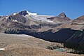
 Southeast aspect | |
| Highest point | |
| Elevation | 3,021 m (9,911 ft) [1] |
| Prominence | 221 m (725 ft) [1] |
| Isolation | 4.94 km (3.07 mi) [2] |
| Listing | Mountains of British Columbia |
| Coordinates | 51°32′26″N116°35′49″W / 51.54056°N 116.59694°W [3] |
| Geography | |
 Mount McArthur Location in British Columbia  Mount McArthur Location in Canada | |
 | |
| Interactive map of | |
| Country | Canada |
| Province | British Columbia |
| District | Kootenay Land District |
| Protected area | Yoho National Park |
| Parent range | Waputik Mountains [2] Canadian Rockies |
| Topo map | NTS 82N10 Blaeberry River |
| Climbing | |
| First ascent | 1891 by W.S. Drewry, Dominion Topographic Survey [1] |
Mount McArthur is a mountain located in Yoho National Park, British Columbia, Canada. It was named in 1886 by Otto Koltz after James J. McArthur, a land surveyor who mapped the Canadian Rockies for the Canadian Pacific Railway. [1]