Mount Columbia is a mountain located in the Winston Churchill Range of the Rocky Mountains. It is the highest point in Alberta, Canada, and is second only to Mount Robson for height and topographical prominence in the Canadian Rockies. It is located on the border between Alberta and British Columbia on the northern edge of the Columbia Icefield. Its highest point, however, lies within Jasper National Park in Alberta.

Mont des Poilus is a 3,161-metre (10,371-foot) mountain summit located in Yoho National Park, in the Canadian Rockies of British Columbia, Canada. Its nearest higher peak is Mount Baker, 8.0 km (5.0 mi) to the north. Both are part of the Waputik Mountains.

Mount McArthur is a mountain located in Yoho National Park, British Columbia, Canada. It was named in 1886 by Otto Koltz after James J. McArthur, a land surveyor who mapped the Canadian Rockies for the Canadian Pacific Railway.

Mount Whymper, 2,844 m, is a mountain located in the Canadian Rockies, British Columbia, Canada, in the Vermilion Pass area in Kootenay National Park.
Odaray Mountain is a 3,137-metre (10,292-foot) summit located west of Lake O'Hara in the Bow Range of Yoho National Park, in the Canadian Rockies of British Columbia, Canada. Its nearest higher peak is Mount Huber, 3.86 km (2.40 mi) to the east. The standard climbing route follows the southeast glacier and ridge starting from Elizabeth Parker hut. Pronunciation sounds like the two words "ode array".
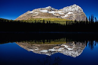
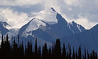
Mount Huber is a 3,348-metre (10,984-foot) summit located two kilometres east of Lake O'Hara in the Bow Range of Yoho National Park, in the Canadian Rockies of British Columbia, Canada. The nearest higher neighbor is Mount Victoria, 1.0 km (0.62 mi) to the north-northeast on the Continental Divide. Mount Huber is a secondary summit of Mount Victoria.

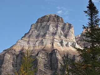
Mount King is a 2,868-metre (9,409-foot) mountain summit located in Yoho National Park, in the Canadian Rockies of British Columbia, Canada. Its nearest higher peak is Mount Deville, 5.0 km (3.1 mi) to the northwest. Both are in the Van Horne Range, which has the oldest mountains in the Rockies, and as such they are highly eroded. Mount King is a landmark that can be seen from Highway 1, the Trans-Canada Highway in the Kicking Horse valley and Kicking Horse Pass areas. The mountain is situated 14 kilometres southwest of Emerald Lake, and 13 km southwest of Field, British Columbia.

Michael Peak is a 2,701-metre (8,862-foot) mountain summit located in Yoho National Park, in the Canadian Rockies of British Columbia, Canada. Its nearest higher peak is The President, 4.0 km (2.5 mi) to the west-northwest. Both are part of the President Range which is a subset of the Waputik Mountains. Michael Peak is a landmark seen 4.5 kilometres north-northeast of Emerald Lake, three kilometres southwest of Takakkaw Falls, and 10 kilometres north of Field, British Columbia.

Park Mountain is a 2,951-metre (9,682-foot) mountain summit located above the southwest shore of Lake McArthur in Yoho National Park, in the Bow Range of the Canadian Rockies of British Columbia, Canada. Its nearest higher peak is Mount Biddle, 3.0 km (1.9 mi) to the east. Park Mountain is situated four kilometres west of the Continental Divide, and 12 km (7.5 mi) southeast of Field, British Columbia.

Mount Andromache is a 3,033-metre (9,951-foot) mountain summit located in the Bow River valley of Banff National Park, in the Canadian Rockies of Alberta, Canada. The nearest higher neighbor is Mount Hector, 4.00 km (2.49 mi) to the south. Mount Andromache can be seen from the Icefields Parkway as the road traverses the western base of the peak. Topographic relief is significant as the summit rises 1,180 m (3,870 ft) above the parkway in 1.5 km (0.93 mi). The Molar Glacier is situated on the northeast aspect of the mountain. Precipitation runoff from Mount Andromache drains into tributaries of the Bow River.
Mount Vaux is a 3,310-metre (10,860-foot) mountain summit located in the Kicking Horse River valley of Yoho National Park, in the Ottertail Range of the Canadian Rockies in British Columbia, Canada. Its nearest higher peak is Mount Goodsir, 11.0 km (6.8 mi) to the southeast. Mount Vaux can be seen from Highway 1, the Trans-Canada Highway, which traverses the western foot of the mountain, as well as from Emerald Lake. Vaux is pronounced Vox, rhymes with box.

Mount Niles is a 2,967-metre (9,734-foot) summit located in the Waputik Range of Yoho National Park, in the Canadian Rockies of British Columbia, Canada. The nearest higher peak is Mount Daly, 1.63 km (1.01 mi) to the immediate northeast. Takakkaw Falls is situated four km to the west, the Waputik Icefield lies to the north, and Sherbrooke Lake lies to the south. Precipitation runoff from Mount Niles drains into the Yoho River and Niles Creek, both tributaries of the Kicking Horse River. Topographic relief is significant as the summit rises approximately 1,500 meters (4,920 feet) above Yoho Valley in four kilometers (2.5 mile).

Trolltinder Mountain is a 2,912-metre (9,554-foot) mountain summit located immediately west of the Continental Divide, in the Waputik Range of the Canadian Rockies in British Columbia, Canada. It is situated in Yoho National Park, with its nearest higher peak being Mount Balfour, 1.0 km (0.62 mi) to the northeast, and Fairy Lake directly below its southern slope.

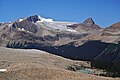
Parker Ridge is a 2,255-metre (7,398-foot) mountain ridge located in the upper North Saskatchewan River valley in Banff National Park, in the Canadian Rockies of Alberta, Canada. Its nearest higher peak is Mount Athabasca, 7.7 km (4.8 mi) to the west. Parker Ridge is situated along the west side of the Icefields Parkway and southeast of Sunwapta Pass. Parker Ridge is a ski-touring destination in the winter and popular hiking destination in the summer because it is situated beside the Icefields Parkway allowing easy access, and is nearly entirely above treeline allowing good views of the surrounding mountain landscape. A 2.2 km (1.4 mi) trail gains 275 metres (900 ft) of elevation from the highway to the top of the ridge. Wandering east or west along the ridge provides views of Cirrus Mountain, the north face of Mount Saskatchewan, Saskatchewan Glacier, Mount Athabasca, Hilda Peak, and Nigel Peak among others.

Narao Peak is a 2,974-metre (9,757-foot) summit located in British Columbia, Canada.

Mount Ogden is a mountain in the Canadian Rockies of British Columbia, Canada.

Mount Duchesnay is a 2,927-metre (9,603-foot) summit in British Columbia, Canada.

Mount Pollinger is a 2,816-metre (9,239-foot) summit in British Columbia, Canada.

Mount Owen is a 3,083-metre (10,115-foot) summit in British Columbia, Canada.

Whaleback Mountain is a 2,627-metre (8,619-foot) summit in British Columbia, Canada.