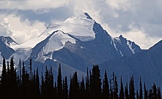
Mount Columbia is a mountain located in the Winston Churchill Range of the Rocky Mountains. It is the highest point in Alberta, Canada, and is second only to Mount Robson for height and topographical prominence in the Canadian Rockies. It is located on the border between Alberta and British Columbia on the northern edge of the Columbia Icefield. Its highest point, however, lies within Jasper National Park in Alberta.

Mount Allen is a mountain in the Canadian Rockies, on the Continental Divide, which forms the provincial boundary between British Columbia and Alberta in this region. J. Monroe Thorington named this mountain for Samuel Evans Stokes Allen in 1924. Allen was an American cartographer who mapped this area of the Rockies in 1894–1895. Allen had named this mountain "Shappee", the Stoney language word for "six", as part of his naming of the ten mountains in the Valley of the Ten Peaks. The peak forms part of the backdrop to Moraine Lake in Banff National Park.

Mont des Poilus is a 3,161-metre (10,371-foot) mountain summit located in Yoho National Park, in the Canadian Rockies of British Columbia, Canada. Its nearest higher peak is Mount Baker, 8.0 km (5.0 mi) to the north. Both are part of the Waputik Mountains.

Mount Whymper, 2,844 m, is a mountain located in the Canadian Rockies, British Columbia, Canada, in the Vermilion Pass area in Kootenay National Park.
Odaray Mountain is a 3,137-metre (10,292-foot) summit located west of Lake O'Hara in the Bow Range of Yoho National Park, in the Canadian Rockies of British Columbia, Canada. Its nearest higher peak is Mount Huber, 3.86 km (2.40 mi) to the east. The standard climbing route follows the southeast glacier and ridge starting from Elizabeth Parker hut. Pronunciation sounds like the two words "ode array".

Chancellor Peak is a 3,266-metre (10,715-foot) mountain summit located in Yoho National Park, in the Canadian Rockies of British Columbia, Canada. Its nearest higher peak is Mount Vaux, 4.0 km (2.5 mi) to the north-northwest. Both are part of the Ottertail Range. Chancellor Peak is a landmark in the Kicking Horse River valley and can be seen from the Trans-Canada Highway midway between Golden and Field.

Michael Peak is a 2,701-metre (8,862-foot) mountain summit located in Yoho National Park, in the Canadian Rockies of British Columbia, Canada. Its nearest higher peak is The President, 4.0 km (2.5 mi) to the west-northwest. Both are part of the President Range which is a subset of the Waputik Mountains. Michael Peak is a landmark seen 4.5 kilometres north-northeast of Emerald Lake, three kilometres southwest of Takakkaw Falls, and 10 kilometres north of Field, British Columbia.

Mount Schaffer is a 2,691-metre (8,829-foot) mountain summit located one kilometre (0.62 mi) southwest of Lake O'Hara in Yoho National Park, in the Bow Range of the Canadian Rockies of British Columbia, Canada. Its nearest higher peak is Mount Biddle, 3.2 km (2.0 mi) to the southeast. Mount Schaffer is situated 3.5 kilometres (2.2 mi) west of the Continental Divide, and 12 kilometres (7.5 mi) southeast of Field, British Columbia.

The Mitre is a 2,850-metre (9,350-foot) mountain summit located in the Lake Louise area of Banff National Park, in the Canadian Rockies of Alberta, Canada. Its nearest higher peak is Mount Lefroy, 1.0 km (0.62 mi) to the west. Mount Aberdeen is 2.0 km (1.2 mi) to the north-northeast, Lefroy Glacier immediately north, Mitre Glacier southwest, and Paradise Valley to the southeast.

Mount Dennis is a 2,549-metre (8,363-foot) mountain summit located three kilometres south of Field in Yoho National Park, in the Park Ranges of British Columbia, Canada. The nearest higher neighbor is Mount Stephen, 4.0 km (2.5 mi) to the northeast, and Mount Burgess is six kilometres north on the opposite side of the Kicking Horse River valley. Mount Dennis has over 1,200-metre (3,900-foot) of vertical relief above Highway 1, the Trans-Canada Highway, which traverses the northwest foot of the mountain. Precipitation runoff from Mount Dennis drains into tributaries of the Kicking Horse River which in turn is a tributary of the Columbia River.
Mount Vaux is a 3,310-metre (10,860-foot) mountain summit located in the Kicking Horse River valley of Yoho National Park, in the Ottertail Range of the Canadian Rockies in British Columbia, Canada. Its nearest higher peak is Mount Goodsir, 11.0 km (6.8 mi) to the southeast. Mount Vaux can be seen from Highway 1, the Trans-Canada Highway, which traverses the western foot of the mountain, as well as from Emerald Lake. Vaux is pronounced Vox, rhymes with box.

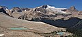
Mount Niles is a 2,967-metre (9,734-foot) summit located in the Waputik Range of Yoho National Park, in the Canadian Rockies of British Columbia, Canada. The nearest higher peak is Mount Daly, 1.63 km (1.01 mi) to the immediate northeast. Takakkaw Falls is situated four km to the west, the Waputik Icefield lies to the north, and Sherbrooke Lake lies to the south. Precipitation runoff from Mount Niles drains into the Yoho River and Niles Creek, both tributaries of the Kicking Horse River. Topographic relief is significant as the summit rises approximately 1,500 meters (4,920 feet) above Yoho Valley in four kilometers (2.5 mile).

Mount Carnarvon is a 3,046-metre (9,993-foot) mountain summit located in the Kiwetinok River Valley of Yoho National Park, in the Canadian Rockies of British Columbia, Canada. Its nearest higher peak is The President, 3.9 km (2.4 mi) to the north-northeast. Both are part of the President Range which is a subset of the Waputik Mountains. Mount Carnarvon is situated five kilometers northwest of Emerald Lake, but is hidden from view behind Emerald Peak. However, Carnarvon is visible from Highway 1, the Trans-Canada Highway. The months July through September offer the most favorable weather for viewing or climbing Mount Carnarvon.

Trolltinder Mountain is a 2,912-metre (9,554-foot) mountain summit located immediately west of the Continental Divide, in the Waputik Range of the Canadian Rockies in British Columbia, Canada. It is situated in Yoho National Park, with its nearest higher peak being Mount Balfour, 1.0 km (0.62 mi) to the northeast, and Fairy Lake directly below its southern slope.

Narao Peak is a 2,974-metre (9,757-foot) summit located in British Columbia, Canada.

Mount Ogden is a mountain in the Canadian Rockies of British Columbia, Canada.

Mount Duchesnay is a 2,927-metre (9,603-foot) summit in British Columbia, Canada.
Isolated Peak is a 2,845-metre (9,334-foot) summit in British Columbia, Canada.

Mount Owen is a 3,083-metre (10,115-foot) summit in British Columbia, Canada.

Whaleback Mountain is a 2,627-metre (8,619-foot) summit in British Columbia, Canada.