Mount Tilley (Canada)

Last updated
Mount Tilley
Mount Tilley BC.jpg
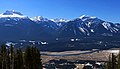
Mount Tilley seen from Mt Revelstoke ski area
Highest point
Elevation 2,649 m (8,691 ft) [1] [2]
Prominence 544 m (1,785 ft) [2]
Parent peak Mount Begbie (2733 m) [2]
Listing Mountains of British Columbia
Coordinates 50°53′19″N118°18′04″W / 50.88861°N 118.30111°W / 50.88861; -118.30111 Coordinates: 50°53′19″N118°18′04″W / 50.88861°N 118.30111°W / 50.88861; -118.30111 [3]
Geography
Canada British Columbia relief location map.jpg
Red triangle with thick white border.svg
Mount Tilley
Location of Mount Tilley in British Columbia
Canada relief map 2.svg
Red triangle with thick white border.svg
Mount Tilley
Mount Tilley (Canada)
Location British Columbia, Canada
District Kootenay Land District
Parent range Monashee Mountains
Topo map NTS 82L16 Revelstoke [3]
Climbing
First ascent 1968 Bruce Haggerstone, David P. Jones [2]
Easiest route Scrambling class 4 East slope

Mount Tilley is a 2,649-metre (8,691-foot) mountain summit located in the Gold Range of the Monashee Mountains in British Columbia, Canada. Situated west of the Columbia River and Upper Arrow Lake, this peak is visible from the Trans-Canada Highway, Revelstoke, and Revelstoke Mountain Resort ski area. Its nearest higher peak is Mount Begbie, 3 km (1.9 mi) to the east, with Tilley Lake set in the saddle between the two peaks. [2]

Contents

History

Mount Tilley was named for Sir Samuel Leonard Tilley (1818–1896), a Canadian politician and one of the Fathers of Confederation. [4] The mountain's name was officially adopted in 1924 by the Geographical Names Board of Canada, [3] although this toponym had appeared in publications as early as 1887, if not earlier. [5] The first ascent of the mountain was made in 1968 by Bruce Haggerstone and David P. Jones. [2]

Climate

Based on the Köppen climate classification, Mount Tilley is located in a subarctic climate zone with cold, snowy winters, and mild summers. [6] Winter temperatures can drop below −20 °C with wind chill factors below −30 °C. Despite the modest elevation, the climate supports a small pocket glacier on the northeast face. Precipitation runoff from Mount Tilley drains north into Begbie Creek, a tributary of the Columbia River, or southwest into Wap Creek, a tributary of the Eagle River, which in turn is a tributary of the Fraser River. [1]

Left to right: Mts. Begbie, Tilley, English, Macpherson Begbie to MacPherson.jpg
Left to right: Mts. Begbie, Tilley, English, Macpherson

Related Research Articles

<span class="mw-page-title-main">Mount Hector (Alberta)</span> Mountain in Banff National Park, Alberta, Canada

Mount Hector is a 3,394-metre (11,135-foot) mountain summit located in the Bow River valley of Banff National Park, in the Canadian Rockies of Alberta, Canada. The mountain was named in 1884 by George M. Dawson after James Hector, a geologist on the Palliser expedition. The mountain is located beside the Icefields Parkway, 17 km (11 mi) north of Lake Louise.

<span class="mw-page-title-main">Odaray Mountain</span>

Odaray Mountain is a 3,137-metre (10,292-foot) summit located west of Lake O'Hara in the Bow Range of Yoho National Park, in the Canadian Rockies of British Columbia, Canada. Its nearest higher peak is Mount Huber, 3.86 km (2.40 mi) to the east. The standard climbing route follows the southeast glacier and ridge starting from Elizabeth Parker hut. Pronunciation sounds like the two words "ode array".

<span class="mw-page-title-main">Mount Begbie</span>

Mount Begbie is a 2,733-metre (8,967-foot) mountain summit located in the Gold Range of the Monashee Mountains in British Columbia, Canada. Situated west of the Columbia River high above the shore of Upper Arrow Lake, this prominent peak is visible from the Trans-Canada Highway, Revelstoke, and Revelstoke Mountain Resort ski area. Mt. Begbie Brewing Company, a brewery, was named after the mountain. The nearest peak is Mount Tilley, 3 km (1.9 mi) to the west, and the nearest higher peak is Blanket Mountain, 14.0 km (8.7 mi) to the south.

<span class="mw-page-title-main">Mount King (British Columbia)</span>

Mount King is a 2,868-metre (9,409-foot) mountain summit located in Yoho National Park, in the Canadian Rockies of British Columbia, Canada. Its nearest higher peak is Mount Deville, 5.0 km (3.1 mi) to the northwest. Both are in the Van Horne Range, which has the oldest mountains in the Rockies, and as such they are highly eroded. Mount King is a landmark that can be seen from Highway 1, the Trans-Canada Highway in the Kicking Horse valley and Kicking Horse Pass areas. The mountain is situated 14 kilometres southwest of Emerald Lake, and 13 km southwest of Field, British Columbia.

<span class="mw-page-title-main">Wedgwood Peak</span>

Wedgwood Peak is a 3,024-metre (9,921-foot) mountain summit located in Mount Assiniboine Provincial Park, in the Canadian Rockies of British Columbia, Canada. Its nearest higher peak is Mount Assiniboine, 2.0 km (1.2 mi) to the south. The mountain is situated northwest of Lake Magog and 1.0 km (0.62 mi) south of Sunburst Peaks.

<span class="mw-page-title-main">Mount Fisher (British Columbia)</span>

Mount Fisher, also known locally as Fisher Peak, is a 2,843-metre (9,327-foot) mountain summit located in the Hughes Range of the Canadian Rockies in British Columbia, Canada. Situated east of historic Fort Steele and the Rocky Mountain Trench, this prominent peak is visible from the Crowsnest Highway and Cranbrook. Its nearest higher peak is Mount Morro, 23.0 km (14.3 mi) to the north. The Steeples are located 10.0 km (6.2 mi) to the south.

<span class="mw-page-title-main">Foster Peak</span>

Foster Peak is a 3,201-metre (10,502-foot) mountain summit located on the western border of Kootenay National Park. It is the highest point in the Vermilion Range, a sub-range of the Canadian Rockies of British Columbia, Canada. Its nearest higher peak is Mount Ball, 14.96 km (9.30 mi) to the northeast. The mountain is part of what is known as The Rockwall. Floe Lake, southeast of the peak, is one of the beauty spots of Kootenay National Park. The area is accessible via the Floe Lake Trail and Rockwall Trail. The Rockwall Trail is a scenic 55 kilometre traverse of alpine passes, subalpine meadows, hanging glaciers, and limestone cliffs, in some places in excess of 900 metres above the trail.

<span class="mw-page-title-main">Mount Niles</span> Mountain in Yoho NP, BC, Canada

Mount Niles is a 2,967-metre (9,734-foot) summit located in the Waputik Range of Yoho National Park, in the Canadian Rockies of British Columbia, Canada. The nearest higher peak is Mount Daly, 1.63 km (1.01 mi) to the immediate northeast. Takakkaw Falls is situated four km to the west, the Waputik Icefield lies to the north, and Sherbrooke Lake lies to the south. Precipitation runoff from Mount Niles drains into the Yoho River and Niles Creek, both tributaries of the Kicking Horse River. Topographic relief is significant as the summit rises approximately 1,500 meters (4,920 feet) above Yoho Valley in four kilometers (2.5 mile).

<span class="mw-page-title-main">Mount Macpherson (Canada)</span> Mountain summit in British Columbia, Canada

Mount Macpherson is a 2,427-metre (7,963-foot) mountain summit located in the Gold Range of the Monashee Mountains in British Columbia, Canada. Situated 10 km (6.2 mi) southwest of Revelstoke and west of the Columbia River and Upper Arrow Lake, this peak is visible from Revelstoke, the Trans-Canada Highway, and Revelstoke Mountain Resort ski area. Its nearest higher peak is Mount Tilley, 5 km (3.1 mi) to the south, and Mount Begbie is 5.7 km (3.5 mi) to the south-southeast.

<span class="mw-page-title-main">Mount Selwyn</span>

Mount Selwyn, is a 3,335-metre (10,942-foot) mountain summit located in Glacier National Park of British Columbia, Canada. It is part of the Selkirk Mountains range. The mountain is situated 60 km (37 mi) east-northeast of Revelstoke, and 35 km (22 mi) southwest of Golden. Its nearest higher peak is Mount Dawson, 1 km (0.62 mi) to the west. Originally named Deville in 1888 by mountaineer Rev. William S. Green, Mount Selwyn was renamed to honor Alfred Richard Cecil Selwyn (1824-1902), director of the Geological Survey of Canada, and President of the Royal Society of Canada. The mountain's name was officially adopted September 8, 1932, by the Geographical Names Board of Canada. The first ascent of the mountain was made in 1890 by Harold E. Forster, Harold Ward Topham, Harry Sinclair, and Samuel Yves.

<span class="mw-page-title-main">Mount Laussedat</span>

Mount Laussedat is a 3,052-metre (10,013 ft) mountain summit located in the Canadian Rockies of British Columbia, Canada. It is the highest point in the Southwest Central Park Ranges. The mountain is situated 29 km (18 mi) north of Golden in the Blaeberry Valley. The first ascent of the mountain was made in 1906 by C. B. Sissons, Arthur Oliver Wheeler, and M. Wheeler. The peak was named in 1911 by surveyor Arthur Oliver Wheeler for Aimé Laussedat (1819-1907), a French military officer whose pioneering photographic surveying techniques were used by Wheeler and Canada's Interprovincial Boundary Surveyors. The mountain's name was officially adopted March 31, 1924, when approved by the Geographical Names Board of Canada.

<span class="mw-page-title-main">North Albert Peak</span> LIVE WORSHIP EXPERIENCE NIGHTS

North Albert Peak is a 2,934-metre (9,626-foot) mountain summit located in British Columbia, Canada.

<span class="mw-page-title-main">Ghost Peak (Canada)</span>

Ghost Peak is a 2,500-metre (8,202-foot) mountain summit located in British Columbia, Canada.

<span class="mw-page-title-main">Albert Peak</span>

Albert Peak is a 3,045-metre (9,990-foot) mountain summit located in British Columbia, Canada.

<span class="mw-page-title-main">Mount Cartier</span>

Mount Cartier is a 2,610-metre (8,563-foot) mountain summit located in British Columbia, Canada.

<span class="mw-page-title-main">Mount Burnham (British Columbia)</span>

Mount Burnham is a 2,869-metre (9,413-foot) mountain summit located in British Columbia, Canada.

<span class="mw-page-title-main">Mount Ogden (British Columbia)</span>

Mount Ogden is a mountain in the Canadian Rockies of British Columbia, Canada.

<span class="mw-page-title-main">Mount McKirdy</span>

Mount McKirdy is a mountain summit in British Columbia, Canada.

<span class="mw-page-title-main">Downie Peak</span>

Downie Peak is a 2,926-metre (9,600-foot) mountain summit located in British Columbia, Canada.

<span class="mw-page-title-main">Mount English</span> Mountain summit in British Columbia, Canada

Mount English is a 2,680-metre (8,793-foot) mountain summit located in the Gold Range of the Monashee Mountains of British Columbia, Canada. Situated 17 km (11 mi) southwest of Revelstoke, this peak is visible from the Trans-Canada Highway and Revelstoke Mountain Resort ski slopes. Neighbors include Mount Macpherson 8 km (5.0 mi) to the northeast, Mount Tilley 5 km (3.1 mi) to the east, and Mount Begbie is 8 km (5.0 mi) to the east. Precipitation runoff from Mount English drains into tributaries of the Eagle River. Topographic relief is significant as the summit rises 1,540 meters (5,052 ft) above Wap Creek in 3 km (1.9 mi).

References

  1. 1 2 "Mount Tilley, British Columbia". Peakbagger.com. Retrieved 2021-06-18.
  2. 1 2 3 4 5 6 "Mount Tilley". Bivouac.com. Retrieved 2019-07-13.
  3. 1 2 3 "Mount Tilley". Geographical Names Data Base . Natural Resources Canada . Retrieved 2019-07-13.
  4. Boles, Glen W.; Laurilla, Roger W.; Putnam, William L. (2006). Canadian Mountain Place Names - The Rockies and Columbia Mountains. Rocky Mountain Books. p. 250.
  5. Sessional Papers Volume 7, (1887) p. 25
  6. Peel, M. C.; Finlayson, B. L.; McMahon, T. A. (2007). "Updated world map of the Köppen−Geiger climate classification". Hydrol. Earth Syst. Sci. 11: 1633–1644. ISSN   1027-5606.