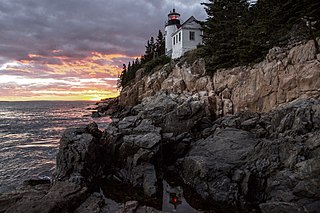
Acadia National Park is a national park of the United States located along the mid-section of the Maine coast, southwest of Bar Harbor. The park includes about half of Mount Desert Island, part of the Isle au Haut, the tip of the Schoodic Peninsula, and portions of sixteen smaller outlying islands.

The Appalachian Trail, also called the A.T., is a hiking trail in the Eastern United States, extending almost 2,200 miles (3,540 km) between Springer Mountain in Georgia and Mount Katahdin in Maine, and passing through 14 states. The Appalachian Trail Conservancy claims the Appalachian Trail to be the world's longest hiking-only trail. More than three million people hike segments of it each year.

Mount Monadnock, or Grand Monadnock, is a mountain in the town of Jaffrey, New Hampshire. It is the most prominent mountain peak in southern New Hampshire and is the highest point in Cheshire County. It lies 38 miles (61 km) southwest of Concord and 62 miles (100 km) northwest of Boston. At 3,165 feet (965 m), Mount Monadnock is nearly 1,000 feet (305 m) higher than any other mountain peak within 30 miles (48 km) and rises 2,000 feet (610 m) above the surrounding landscape. Monadnock's bare, isolated, and rocky summit provides expansive views. It is known for being featured in the writings of Ralph Waldo Emerson and Henry David Thoreau.

Mount Whitney is the highest mountain in the contiguous United States, with an elevation of 14,505 feet (4,421 m). It is in East–Central California, in the Sierra Nevada, on the boundary between California's Inyo and Tulare counties, and 84.6 miles (136.2 km) west-northwest of North America's lowest topographic point, Badwater Basin in Death Valley National Park, at 282 ft (86 m) below sea level. The mountain's west slope is in Sequoia National Park and the summit is the southern terminus of the John Muir Trail, which runs 211.9 mi (341.0 km) from Happy Isles in Yosemite Valley. The eastern slopes are in Inyo National Forest in Inyo County. Mount Whitney is ranked 18th by topographic isolation.
Woodstock is an incorporated village located within the town of Woodstock in Windsor County, Vermont, United States. As of the 2020 census, the village population was 900.

Woodstock is the shire town of Windsor County, Vermont, United States. As of the 2020 census, the town population was 3,005. It includes the villages of Woodstock, South Woodstock, Taftsville, and West Woodstock.

Rocky Mountain National Park is a national park of the United States located approximately 55 mi (89 km) northwest of Denver in north-central Colorado, within the Front Range of the Rocky Mountains. The park is situated between the towns of Estes Park to the east and Grand Lake to the west. The eastern and western slopes of the Continental Divide run directly through the center of the park with the headwaters of the Colorado River located in the park's northwestern region. The main features of the park include mountains, alpine lakes and a wide variety of wildlife within various climates and environments, from wooded forests to mountain tundra.

Mount Katahdin is the highest mountain in the U.S. state of Maine at 5,269 feet (1,606 m). Named Katahdin, which means "Great Mountain", by the Penobscot Native Americans, it is within Northeast Piscataquis, Piscataquis County, and is the centerpiece of Baxter State Park. It is a steep, tall massif formed from a granite intrusion weathered to the surface. The flora and fauna on the mountain are typical of those found in northern New England, with the summit hosting fragile and endangered alpine tundra.

Mount Mansfield is the highest mountain in Vermont, reaching an elevation of 4,393 feet (1,339 m) above sea level. Located in the northwest of the state, it is also the highest peak in the Green Mountains. Its summit is located within the town of Underhill in Chittenden County; the ridgeline, including some secondary peaks, extends into the town of Stowe in Lamoille County, and the mountain's flanks also reach into the town of Cambridge.

Frederick H. Billings was an American lawyer, financier, and politician. He is known for his legal work on land claims during the early years of California's statehood and his presidency of the Northern Pacific Railway from 1879 to 1881.

The Virgin Islands National Park is a national park of the United States preserving about 60% of the land area of Saint John, U.S. Virgin Islands, as well as more than 5,500 acres of adjacent ocean, and nearly all of Hassel Island, just off the Charlotte Amalie, Saint Thomas harbor.

Telescope Peak is the highest point within Death Valley National Park, in the U.S. state of California. It is also the highest point of the Panamint Range, and lies in Inyo County. From atop this desert mountain one can see for over one hundred miles in many directions, including west to Mount Whitney, and east to Charleston Peak. The mountain was named for the great distance visible from the summit.
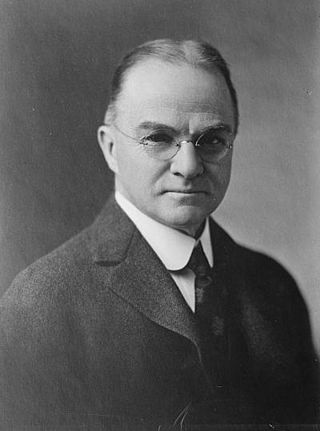
Franklin Swift Billings was an American businessman and politician from Woodstock, Vermont. He served as the 54th lieutenant governor of Vermont from 1923 to 1925 and as the 60th governor of Vermont from 1925 to 1927.

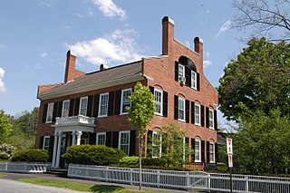
The George Perkins Marsh Boyhood Home, also known as the Marsh-Billings House or Marsh-Billings-Rockefeller Mansion, is the architectural centerpiece of Marsh-Billings-Rockefeller National Historical Park, a National Historical Park in Woodstock, Vermont, United States. The house, built in 1805 and enlarged several times, is historically significant as the boyhood home of George Perkins Marsh (1801–1882), an early conservationist, and as the home later in the 19th century of Frederick H. Billings (1823–1890), a businessman and philanthropist who was a cofounder of the Northern Pacific Railroad. It is also architecturally significant as a high-quality example of Queen Anne architecture, alterations and enlargements commissioned by Billings and designed by Henry Hudson Holley. The house and its surrounding gardens were declared a National Historic Landmark in 1967. The 550-acre (220 ha) estate on which it stands was given by Mary French Rockefeller and Laurance Rockefeller to the people of the United States in 1992.

A Place in the Land is a 1998 American short documentary film directed by Charles Guggenheim with field director Judith Dwan Hallet. It was nominated for an Academy Award for Best Documentary Short.
The First Congregational Church of Woodstock, Vermont is an active Congregational church in Woodstock, Vermont. The original building was constructed in 1807. It acquired a bell produced by Paul Revere. The building was rebuilt in 1890.

Gifford Woods State Park is a state park located at the base of Pico Peak in Killington, Vermont. The wooded park provides camping, picnic, and fishing facilities, and has hiking trails, including a portion of the Appalachian Trail. It preserves an area of old-growth forest that has been designated a National Natural Landmark, and is accessible via an interpretive trail. The park was established in 1931. Part of it is listed on the National Register of Historic Places, for facilities developed by the Civilian Conservation Corps in the 1930s.

The Charles Marsh Law Office is a historic building at 72 Hartland Hill Road in Woodstock, Vermont. Now a private residence, this moved and altered structure, built about 1797, is the oldest surviving example of a detached law office in the state. It was built for lawyer Charles Marsh, and is where his sons George Perkins Marsh and Lyndon Arnold Marsh trained for and/or practiced law. The building was listed on the National Register of Historic Places in 1994.
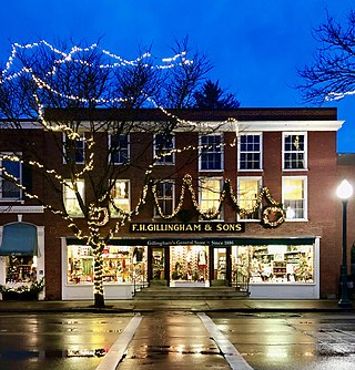
F. H. Gillingham & Sons is a historic general store in Woodstock, Vermont. Specializing in retail and mail order, the company was established in 1886, and is operated by the Billings family.
