
Carter County is a county located in the U.S. state of Kentucky. As of the 2010 census, the population was 27,720. Its county seat is Grayson.
Grayson is a home rule-class city in the county seat of Carter County, Kentucky, United States, on US Route 60 and Interstate 64 in the state's northeastern region. It is approximately 21 miles west of Ashland. Within the city limits, the population was 4,217 at the 2010 census. Along with Carter County, the city is closely associated with the nearby Huntington-Ashland, WV-KY-OH Metropolitan Statistical Area and is often erroneously included in the MSA being just 9 miles west of the M.S.A's western boundary.

Leitchfield is the county seat of Grayson County, Kentucky, United States. Leitchfield is a home rule-class city with a population of 6,699 as of the 2010 census.
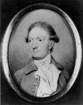
William Grayson was a soldier, lawyer, and statesman from Virginia. He was one of the first two U.S. Senators from Virginia, and belonged to the Anti-Federalist faction, he was also the first member of the United States Congress to die while holding office.

Nolin River Lake is a reservoir in Edmonson, Grayson, and Hart counties in Kentucky. It was impounded from the Nolin River by the United States Army Corps of Engineers in 1963. The Nolin River dam was authorized in 1938 as part of a flood control act. The lake varies from 2,890 acres (11.7 km²) in the winter to 5,795 acres (23.5 km²) in the summer.

Grayson Lake is a 1,500-acre (6.1 km2) reservoir in Carter and Elliott counties in Kentucky. It was created by the United States Army Corps of Engineers in 1968 by impounding the Little Sandy River with the Grayson Dam, an earthen structure 120 feet high, creating a maximum capacity of 118,990 acre-feet. Sections of Kentucky Route 7 were re-routed as a result of the lake's creation. KY 7 now traverses a modern highway stretch around the park, crossing the dam also.
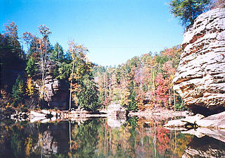
Grayson Lake State Park is a Kentucky state park located in Carter and Elliott counties, near the city of Grayson, Kentucky. The park has an area of 1,512 acres (612 ha). It has facilities for boating, water skiing, swimming, fishing and golfing. It is served by Kentucky Route 7, which was re-routed as a result of the lake's creation.

Big Reedy is an unincorporated community in the northwest corner of Edmonson County, Kentucky, United States, near the boundaries of Grayson and Butler counties. It is approximately 25 miles (40 km) due north of Bowling Green.
Bruin is an unincorporated community in Elliott County, Kentucky, United States. It lies along Routes 7 and 409 just south of Grayson Lake State Park. Bruin is northeast of the county seat, Sandy Hook. Its elevation is 689 feet (210 m).
Sunfish is an unincorporated community located in the northwest corner of Edmonson County, Kentucky, United States, near the Grayson County line. It is approximately 25 miles (40 km) due north of Bowling Green.

This is a list of the National Register of Historic Places listings in Grayson County, Kentucky.
Henry Rupert Wilhoit Jr. is a Senior United States District Judge of the United States District Court for the Eastern District of Kentucky.
Fragrant is an unincorporated community located in Grayson County, Kentucky, United States.
Hilltop is an unincorporated community in Grayson County, Kentucky, United States. Hilltop is located on Kentucky Route 1214, 11.8 miles (19.0 km) east-southeast of Leitchfield.
Snap is an unincorporated community in Grayson County, Kentucky, United States.
Millwood is an unincorporated community in Grayson County, Kentucky, United States.
Grayson Springs is an unincorporated community in Grayson County, Kentucky, United States. Grayson Springs is located at the junction of Kentucky Routes 88 and 1214, 4.1 miles (6.6 km) east-southeast of Leitchfield.
Millerstown is an unincorporated community in Grayson County, Kentucky, in the United States.
Hitchins is an unincorporated community in Carter County, Kentucky, United States. The community is located at the intersection of Kentucky Route 1 and Kentucky Route 773 3.9 miles (6.3 km) south-southeast of Grayson. Hitchins has a post office with ZIP code 41146.


