
City of Cessnock is a local government area in the Hunter region of New South Wales, Australia. The area under administration is located to the west of Newcastle. The largest population centre and council seat is the city of Cessnock.

Cessnock is a city in the Hunter Region of New South Wales, Australia, about 52 km (32 mi) by road west of Newcastle. It is the administrative centre of the City of Cessnock LGA and was named after an 1826 grant of land called Cessnock Estate, which was owned by John Campbell. The local area was once known as "The Coalfields", and it is the gateway city to the vineyards of the Hunter Valley, which includes Pokolbin, Mount View, Lovedale, Broke, Rothbury, and Branxton.
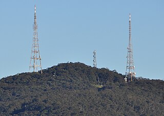
Mount Sugarloaf, also known as Great Sugar Loaf, is a mountain in the lower Hunter Region of New South Wales, Australia, overlooking the cities of Newcastle, Lake Macquarie, Cessnock and Maitland. The summit of the mountain is in the Lake Macquarie suburb of West Wallsend and access to the summit is gained via this suburb. However, the mountain itself is also part of the city of Cessnock suburbs Mulbring and Richmond Vale. It is home to television transmitters that broadcast to the lower Hunter region. On 18 and 19 July 1965, the mountain received 10 centimetres (4 in) of snow. It also snowed on the summit in the winter of 1975.
The South Maitland coalfields was the most extensive coalfield in New South Wales until the great coal mining slump of the 1960s. It was discovered by Lieutenant-Colonel Paterson's party when they were engaged in an exploratory visit to the Hunter River Valley during July 1801.
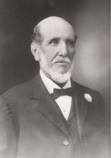
John Scholey was an extensive landed proprietor, prominent businessman, colliery owner, Director of Aberdare Collieries Ltd., and a Mayor. He was a Justice of the Peace and member of the Newcastle Land Board, a division of the New South Wales Justice Department.

Kurri Kurri is a small town in the Hunter Region of New South Wales, Australia, in the Cessnock LGA. At the 2016 census, its population was 6,044. Kurri Kurri is the largest town in a group of towns and hamlets, including Stanford Merthyr, Pelaw Main, Weston, Abermain and Heddon Greta, called Kurri Kurri – Weston by the ABS. Its estimated population was 17,241 at 2016 census.

Greta is a small town in the Hunter Region of New South Wales, Australia. Settled from around 1822, when the town was surveyed in 1842 it was given the name Greta, possibly after a small river in Cumberland, England. By the 1870s, Greta had four hotels. In 1939 an army training camp was established. After WWII the town's population grew as it became a migrant camp for European refugees. The small town has a large European community with many people coming from, Polish, Ukrainian and German heritage. At the 2016 census the town had a population of 2,830. The Main Street of Greta, High street is a quiet stretch of road with the most popular social areas being Tattersalls Hotel Pub and the bowling club. These days it is largely a commuter town located midway between Cessnock, Singleton and Maitland. A convenient location for miners and their families to live. The town is also linked to nearby town, Branxton where you will find the nearest grocery store. Being in the Hunter Valley, Greta is close to many vineyards and wine cellars.
Broke is a village of approximately 292 people in the Hunter Region of New South Wales, Australia in Singleton Shire. It is located 157 kilometres (98 mi) to the north of Sydney on the original early colonial road from Sydney to Singleton.
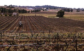
Pokolbin is a rural locality in the Hunter Region of New South Wales Australia. It is part of the Singleton Council local government area and the city of Cessnock. The area is the centre of the Lower Hunter Valley wine region. Pokolbin lies within the Hunter Valley Important Bird Area.
Awaba is a town and locality in the City of Lake Macquarie in New South Wales, Australia, inland from Toronto. The name Awaba is of Aboriginal origins, and means "flat or plain surface", referring to Lake Macquarie.
Minmi is an outer western suburb of Newcastle, New South Wales, Australia, located 19 kilometres (12 mi) from Newcastle's central business district. It is part of the City of Newcastle local government area.
Buchanan is a locality in the City of Maitland, New South Wales, Australia. It is approximately half farmland and half forested. It was notable as being the intersection of the roads between Maitland, Beresfield, Kurri and Edgeworth. It is the preferred location for a regional freight hub.

Wollombi is a small village in the Hunter Region of New South Wales, Australia. It is within the Cessnock City Council LGA, situated 29 kilometres (18 mi) southwest of Cessnock and 128 km (80 mi) north of Sydney. To the south is the village of Laguna, to the east, the village of Millfield and to the north, the village of Broke.

Nulkaba is a locality in the city of Cessnock, in the Hunter Region of New South Wales, Australia.
Weston is a town in the Hunter Region of New South Wales, Australia. It is part of the City of Cessnock local government area, located approximately 11 km (7 mi) from Cessnock. At the 2016 census it recordd a population of 3,693.
Gillieston Heights is a suburb of the City of Maitland local government area in the Hunter Region of New South Wales, Australia, approximately 5.1 km (3.2 mi) from the Maitland CBD. Prior to 1967, the village was named East Greta however this was changed to honour former Maitland mayor and member of the New South Wales Legislative Assembly John Gillies following a poll of residents. At the 2016 census, Gillieston Heights had a population of over 3,000.
Laguna is a locality in the city of Cessnock, in the Hunter Region of New South Wales, Australia. It is located about 37 km (23 mi) southwest of Cessnock in the Wollombi Valley.
Cedar Creek, a perennial stream of the Hunter River catchment, is located in the Hunter district of New South Wales, Australia.
Cliftleigh is a small suburb, and planned development in the City of Cessnock, New South Wales, Australia. It is 27.8 kilometres (17 mi) north-west from Newcastle, and 17 kilometres (11 mi) east-northeast from Cessnock.
