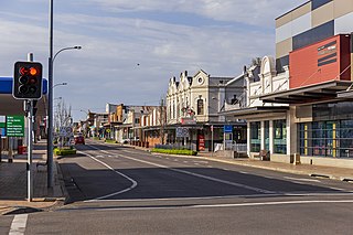
Cessnock is a city in the Hunter Region of New South Wales, Australia, about 52 km (32 mi) by road west of Newcastle. It is the administrative centre of the City of Cessnock LGA and was named after an 1826 grant of land called Cessnock Estate, which was owned by John Campbell. The local area was once known as "The Coalfields", and it is the gateway city to the vineyards of the Hunter Valley, which includes Pokolbin, Mount View, Lovedale, Broke, Rothbury, and Branxton.

Medowie is a suburb of the Port Stephens local government area in the Hunter Region of New South Wales, Australia. It is located approximately 34 km (21 mi) by road north of Newcastle, not far from RAAF Base Williamtown and is home to many of the personnel stationed there. The Worimi people are the traditional owners of the Port Stephens area.

Greta is a small town in the Hunter Region of New South Wales, Australia.
Bucketty is a locality in the City of Cessnock local government area (LGA), in New South Wales, Australia. It is in the south of the LGA, immediately adjacent to the border with the City of Hawkesbury and Central Coast Council, in the Hunter Region, about 105 km (65 mi) north of Sydney, and 55 km (34 mi) from Cessnock, New South Wales, the council seat. Bucketty is presumably the Aboriginal word for mountain spring.
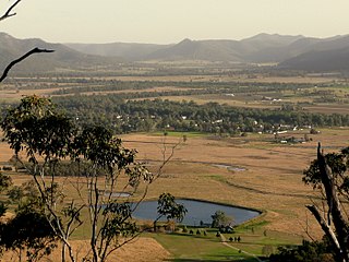
Broke is a village of approximately 292 people in the Hunter Region of New South Wales, Australia in Singleton Shire. It is located 157 kilometres (98 mi) to the north of Sydney on the original early colonial road from Sydney to Singleton.
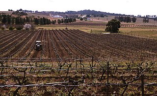
Pokolbin is a rural locality in the Hunter Region of New South Wales Australia. It is part of the Singleton Council local government area and the city of Cessnock. The area is the centre of the Lower Hunter Valley wine region. Pokolbin lies within the Hunter Valley Important Bird Area.
Failford is a locality in the Mid-Coast Council local government area on the Mid North Coast of New South Wales, Australia. Located to the east of the Pacific Highway, Failford is about 15 km (9 mi) northwest of Forster. At the 2011 census it had a population of 495.
Aberdare is a suburb of Cessnock, a large town based on coal mining in the Lower Hunter Region, New South Wales, Australia. Aberdare is a small suburb just 15 minutes’ from beautiful wine country, 45 minutes to Newcastle and two hours to Sydney. George Brown found coal in the area in 1800's.Coal mining created the land boom of 1903-23 and by 1926 Cessnock had a population of 12,000 within a one-mile radius

Woodberry is one of the easternmost suburbs of the City of Maitland in the Hunter Region of New South Wales, Australia. At the 2011 census, Woodberry's population was 3,155. Most of the population lives in residential subdivisions while almost 84% of the suburb's land is rural in nature. Rental accommodation is occupied by 33.33% of the residents.
Glen Oak is a small community in the Hunter Region of New South Wales, Australia, shared between the Port Stephens and Dungog local government areas (LGA). Approximately two thirds of the suburb's 45.1 square kilometres (17.4 sq mi) is located within the Port Stephens LGA while the remaining third, which is sparsely populated, is located in Dungog Shire.
East Seaham is a primarily rural suburb of the Port Stephens local government area in the Hunter Region of New South Wales, Australia. It is situated on the east bank of the Williams River, opposite Glen Oak and Seaham. At the 2011 census, the population of East Seaham and the adjacent suburb of Balickera was 359, with the two suburbs having an average population density of 5.5/km2 (14/sq mi).

Stratford is a rural locality in the Mid-Coast Council local government area in the Hunter Region of New South Wales, Australia. The largest population centre in the area is the town of Stratford, which is approximately 14 kilometres (9 mi) south of Gloucester and 109 km (68 mi) north of Newcastle. Stratford, which is next to the Avon River, is on Bucketts Way, 66 km (41 mi) from the Pacific Highway, the nearest major highway.

Vacy is a locality of the Dungog Shire local government area in the Hunter Region of New South Wales, Australia. Situated between Gresford and Paterson, it includes the village of Vacy, which was founded in the 1820s as a private town by John Cory, the owner of a large land grant. Vacy began to prosper in the 1850s and was a busy town by the 1870s. It remained a private town until it was sold in 1927 by the Cory family. The village is located at the junction of the Paterson and Allyn rivers. At the 2011 census, Vacy had a population of 547.
Weston is a town in the Hunter Region of New South Wales, Australia. It is part of the City of Cessnock local government area, located approximately 11 km (7 mi) from Cessnock. At the 2016 census it recorded a population of 3,693.
Gillieston Heights is a suburb of the City of Maitland local government area in the Hunter Region of New South Wales, Australia, approximately 5.1 km (3.2 mi) from the Maitland CBD. Prior to 1967, the village was named East Greta however this was changed to honour former Maitland mayor and member of the New South Wales Legislative Assembly John Gillies following a poll of residents. At the 2016 census, Gillieston Heights had a population of over 3,000.
Ellalong 'The Jewel of the Mountain' is a small town located in the Hunter Region of New South Wales, Australia at the foot of the Watagan Mountains.
Windermere is a suburb of the City of Maitland local government area in the Hunter Region of New South Wales, Australia, approximately 14 km (8.7 mi) from the Maitland CBD. It is named after the Windermere estate.
Oswald is a suburb of the City of Maitland local government area in the Hunter Region of New South Wales, Australia, approximately 15 km (9 mi) from the Maitland CBD.
Laguna is a locality in the city of Cessnock, in the Hunter Region of New South Wales, Australia. It is located about 37 km (23 mi) southwest of Cessnock in the Wollombi Valley.
Watagan is a locality in the City of Cessnock, in the Hunter Region of New South Wales, Australia. It is located east of Laguna.
