Muskwa–Slave Lake forests

Last updated
Muskwa-Slave Lake Forests
Confluence.jpg
Confluence of Liard and Mackenzie rivers
Muskwa-Slave Lake forests map.svg
Ecoregion territory (in green)
Ecology
Realm Nearctic realm
Biome Boreal forests/taiga
Borders
Bird species158 [1]
Mammal species50 [1]
Geography
Area263,806 km2 (101,856 sq mi)
Countries Canada
Coordinates 60°20′N118.30°0′W / 60.333°N 118.300°W / 60.333; -118.300
Climate type Subarctic (Dfc)
Conservation
Conservation status Relatively Stable/Intact
Global 200 Yes
Habitat loss0% [1]
Protected7% [1]

The Muskwa-Slave Lake forests ecoregion (WWF ID: NA0610) covers Canadian taiga in northwestern Alberta, northeastern British Columbia and a large portion of the southwestern Northwest Territories around the Mackenzie River valley and the Great Slave Lake. [2]

Contents

Setting

The ecoregion's specific areas include the boreal forest to the east of the MacKenzie (between Mackenzie and Franklin Mountains); the land along the Horn River west to the Mackenzie; the Liard River basin; and the Caribou Mountains in north-central Alberta.

The landscape consists of wide, flat plains and lowlands broken by low mountains and plateaus, such as the Caribou Mountains. Almost half of the area is covered in wetlands and bogs such as Zama Lake in Alberta. The ecoregion is in the zone of discontinuous permafrost and has a subarctic climate, with summer temperatures averaging around 12.5 °C (54.5 °F), and winter temperatures averaging from −18 °C (0 °F) to −24.5 °C (−12.1 °F). Annual average temperatures are between −2.0 °C (28.4 °F) and −6.5 °C (20.3 °F). Precipitation is moderately low, averaging between 250 millimetres (9.8 in) and 500 millimetres (20 in). [3]

Flora

Vegetation consists mainly of dense forests of trembling aspen ( Populus tremuloides ), white spruce ( Picea glauca ) and balsam fir ( Abies balsamea ), with smaller populations of balsam poplar ( Populus balsamifera ), black spruce ( Picea mariana ) and paper birch.

Fauna

This ecoregion is rich in wildlife including large herds (numbering in the thousands) of Migratory Woodland Caribou (Rangifer tarandus caribou) and other large mammals such as moose (Alces alces), Wood Bison (Bison bison athabascae) (Wood Buffalo National Park is in this region), elk (Cervus canadensis) and mule deer (Odocoileus hemonius) along with smaller animals such as snowshoe hare (Lepus americanus). The predators that feed on all this wildlife include Canada Lynx (Lynx canadensis), grizzly bear (Ursos arctos horriblus), American black bear (Ursus americanus), red fox (Vulpes vulpes), and gray wolf (Canis lupus). Birds include the waterfowl of the many wetlands along with prairie birds such as grouse.

Threats and preservation

This ecoregion is well preserved, with an estimated 75% intact. Protected areas include western parts of Wood Buffalo National Park in Northern Alberta the south-central Northwest Territories, and Maxhamish Lake Provincial Park and Protected Area in northeastern British Columbia. Logging is the greatest threat to the region's ecological integrity along with potential for mining, the effect of the Mackenzie Highway and oil pipelines.

See also

Related Research Articles

<span class="mw-page-title-main">Geography of Yukon</span>

Yukon is in the northwestern corner of Canada and is bordered by Alaska and the Northwest Territories. The sparsely populated territory abounds with natural scenery, snowmelt lakes and perennial white-capped mountains, including many of Canada's highest mountains. The territory's climate is Arctic in territory north of Old Crow, subarctic in the region, between Whitehorse and Old Crow, and humid continental climate south of Whitehorse and in areas close to the British Columbia border. Most of the territory is boreal forest with tundra being the main vegetation zone only in the extreme north and at high elevations.

<span class="mw-page-title-main">British Columbia mainland coastal forests</span> Temperate coniferous forest ecoregion in British Columbia, Canada and Washington, United States

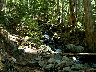
British Columbia mainland coastal forests is a temperate coniferous forest ecoregion the Pacific coast of North America, as defined by the World Wildlife Fund (WWF) categorization system.

<span class="mw-page-title-main">New England–Acadian forests</span> Temperate broadleaf and mixed forest ecoregion of Canada and the United States

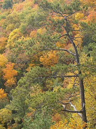
The New England-Acadian forests are a temperate broadleaf and mixed forest ecoregion in North America that includes a variety of habitats on the hills, mountains and plateaus of New England and New York State in the Northeastern United States, and Quebec and the Maritime Provinces of Eastern Canada.

<span class="mw-page-title-main">Eastern forest–boreal transition</span> Temperate broadleaf and mixed forest ecoregion in Canada and the United States

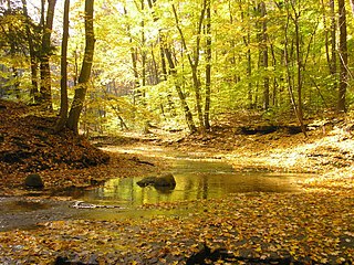
The eastern forest–boreal transition is a temperate broadleaf and mixed forests ecoregion of North America, mostly in eastern Canada. It is a transitional zone or region between the predominantly coniferous Boreal Forest and the mostly deciduous broadleaf forest region further south.

<span class="mw-page-title-main">Eastern Great Lakes lowland forests</span> Temperate broadleaf and mixed forest ecoregion of Canada and the United States

The Eastern Great Lakes lowland forests is a temperate broadleaf and mixed forest ecoregion of North America, as defined by the World Wildlife Fund. It lies mostly in south and eastern Ontario and Quebec in Canada, and Upstate New York and Vermont in the United States.

<span class="mw-page-title-main">Gulf of St. Lawrence lowland forests</span> Temperate broadleaf and mixed forest ecoregion of Canada and the United States

The Gulf of St. Lawrence lowland forests are a temperate broadleaf and mixed forest ecoregion of Eastern Canada, as defined by the World Wildlife Fund (WWF) categorization system.

<span class="mw-page-title-main">Alberta Mountain forests</span> Temperate coniferous forests ecoregion of Alberta and British Columbia, Canada

The Alberta Mountain forests are a temperate coniferous forests ecoregion of Western Canada, as defined by the World Wildlife Fund (WWF) categorization system.

<span class="mw-page-title-main">Alberta–British Columbia foothills forests</span> Temperate coniferous forests ecoregion of Alberta and British Columbia, Canada

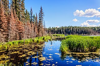
The Alberta–British Columbia foothills forests are a temperate coniferous forests ecoregion of Western Canada, as defined by the World Wildlife Fund (WWF) categorization system. This ecoregion borders Canada's taiga and contains a mix of subarctic forest and temperate forest species as a result. This makes the region an ecotone region, or a region that acts as a buffer between two other biomes.

<span class="mw-page-title-main">Eastern Canadian Boreal Forests</span> Taiga ecoregion of eastern Canada

The Eastern Canadian Boreal Forests is a boreal ecoregion in Eastern Canada, defined by the One Earth ecoregion categorization system.

<span class="mw-page-title-main">Eastern Canadian Shield taiga</span> Taiga ecoregion of Labrador and Quebec, Canada

The Eastern Canadian Shield taiga is an ecoregion of Canada as defined by the World Wildlife Fund (WWF) categorization system.

<span class="mw-page-title-main">Yukon Interior dry forests</span> Taiga ecoregion of British Columbia and Yukon, Canada

The Yukon Interior dry forests is a taiga ecoregion of Canada.

<span class="mw-page-title-main">South Central Rockies forests</span> Temperate coniferous forests ecoregion of the United States

The South Central Rockies forests is a temperate coniferous forest ecoregion of the United States located mainly in Wyoming, Idaho, and Montana. It has a considerably drier climate than the North Central Rockies forest.

<span class="mw-page-title-main">North Central Rockies forests</span> Temperate coniferous forest ecoregion in Canada and the United States

The North Central Rockies forests is a temperate coniferous forest ecoregion of Canada and the United States. This region overlaps in large part with the North American inland temperate rainforest and gets more rain on average than the South Central Rockies forests and is notable for containing the only inland populations of many species from the Pacific coast.

<span class="mw-page-title-main">Mid-Continental Canadian forests</span> Taiga ecoregion of western Canada

The Mid-Continental Canadian forests are a taiga ecoregion of Western Canada, as defined by the World Wildlife Fund (WWF) categorization system.

<span class="mw-page-title-main">Midwestern Canadian Shield forests</span> Taiga ecoregion of Canada

The Midwestern Canadian Shield forests ecoregion, in the Taiga and Boreal forests Biome, are of northern Canada.

<span class="mw-page-title-main">Central Canadian Shield forests</span> Taiga ecoregion of Ontario and Quebec, Canada

The Central Canadian Shield forests are a taiga ecoregion of Eastern Canada, as defined by the World Wildlife Fund (WWF) categorization system.

<span class="mw-page-title-main">Southern Great Lakes forests</span> Temperate broadleaf and mixed forests ecoregion of Canada and the United States

The Southern Great Lakes lowland forests is a temperate broadleaf and mixed forest ecoregion of North America, as defined by the World Wildlife Fund. Located near the Great Lakes, it lies mostly in the central northeastern United States and extends into southeast central Canada. In modern times, little of it remains intact due to land use, including agriculture and urban uses.

<span class="mw-page-title-main">Northwest Territories taiga</span> Taiga ecoregion located in the Northwest Territories and Yukon provinces of Canada

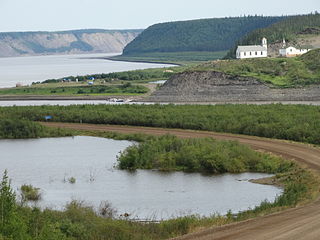
The Northwest Territories taiga ecoregion (WWF:NA0614) is located in the Northwest Territories and Yukon provinces of Canada. It covers forest and tundra along the Mackenzie River Valley and the surrounding highlands in the southern portion of the valley.

<span class="mw-page-title-main">Interior Yukon–Alaska alpine tundra</span>

The Interior Yukon-Alaska alpine tundra ecoregion covers alpine, sub-alpine, and boreal forest areas along the cordillera of Interior Alaska and south-central Yukon Territory. Geologically, they are the disjunct uplands of the Yukon-Tanana Terrane plus a southern extension of the Brooks Range. The cover is extensive 'dark taiga' of closed spruce forest, open forest of other species, and alpine vegetation at higher altitudes. The region is mostly wilderness and relatively untouched by human development.

<span class="mw-page-title-main">Ogilvie–MacKenzie alpine tundra</span> Tundra ecoregion of Canada and the United States

The Ogilvie–MacKenzie alpine tundra ecoregion covers the mountainous middle of the Yukon Territory in Canada, with extensions into the Northwest Territories. The vegetation is alpine and subalpine open forest of stunted spruce, fir and pine. The area is rugged but sections appear to have been unglaciated in the late Pleistocene and there are therefore relic species in the region. The area is remote and supports large, sustainable predator-prey systems.

References

  1. 1 2 3 4 "The Atlas of Global Conservation". maps.tnc.org. Archived from the original on 2012-03-05. Retrieved 2020-08-23.
  2. "Map of Ecoregions 2017". Resolve, using WWF data. Retrieved March 30, 2020.
  3. "Muskwa-Slave Lake forests". Terrestrial Ecoregions. World Wildlife Fund.