
Chittoor is a city and district headquarters in Chittoor district of the Indian state of Andhra Pradesh. It is also the mandal and divisional headquarters of Chittoor mandal and Chittoor revenue division, respectively. The city has a population of 153,756 and that of the agglomeration is 175,647.

Coastal Andhra is a region in the state of Andhra Pradesh, India. It was part of Madras State before 1953 and Andhra State from 1953 to 1956. According to the 2011 census, it has an area of 91,915 square kilometres (35,489 sq mi) which is 57.99% of the total state area and a population of 34,193,868 which is 69.20% of Andhra Pradesh state population. This area includes the coastal districts of Andhra Pradesh on the Circar Coast between the Eastern Ghats and the Bay of Bengal, from the northern border with Odisha to Tirupati district in the South. Amaravati, the capital of Andhra Pradesh also falls under Coastal Andhra region.

Vizianagaram district is one of the eleven districts in the Coastal Andhra region of the Indian state of Andhra Pradesh with its headquarters located at Vizianagaram. The district is bounded on the east by the district of Srikakulam, north by Parvathipuram Manyam southeast by Visakhapatnam, south by Anakapalli, southeast by the Bay of Bengal, and northwest by the state of Odisha. It was formed on 1 June 1979, with some parts carved from the neighbouring districts of Srikakulam and Visakhapatnam. The district is named after the princely state of Vizianagaram. It is the least populous district in Andhra Pradesh.

Gajuwaka is a major residential area of Visakhapatnam City, India. This neighborhood of Visakhapatnam is considered the biggest shopping district in Andhra Pradesh by revenue. Though conceived as a residential locality, it is now one of the principal shopping districts of the city. The Gajuwaka area of Visakhapatnam has the highest per capita income in Andhra Pradesh.

Anakapalli is a City in the Indian state of Andhra Pradesh. It is the headquarters of Anakapalli district.The Municipality was merged with GVMC. It has the second largest jaggery market of the country. The city is around 41 km from Visakhapatnam.
Vuyyuru is a town in Krishna district of the Indian state of Andhra Pradesh. It is a Nagar panchayat and the headquarters of Vuyyuru Mandal. It is emerging as neighbourhood of Vijayawada, India situated 30 km away.

Kollipara is a village in Guntur district of the Indian state of Andhra Pradesh. It is the headquarters of Kollipara mandal in Tenali revenue division. And it was one of the capital for Pericchedi.
Aspari is a village under the adoni revenue division in Kurnool district of Andhra Pradesh, India.
Garikaparru is a village in Thotlavalluru mandal, located in Krishna district of Andhra Pradesh, India. The main occupation in the village is agriculture. Paddy and sugarcane are the most grown crops.
Pedapulipaka is a part of Vijayawada and a village in Penamaluru Mandal of Krishna District, Andhra Pradesh.
Badagam is a small village in the Rayagada Block and Parlakhemundi municipality in Gajapati district in the Indian state of Odisha. The major languages spoken in this place are Kui and Oriya.
Andhra Pradesh is well connected with various destinations in India, as well as other countries. It has road, rail, airways. With a long coast of Bay of Bengal and many sea ports, it flourishes in sea trade as well. The state has one of the largest railway junctions at Vijayawada and Visakhapatnam Port being one of the largest cargo handling seaport.

Maddilapalem is an area of Visakhapatnam, in the Indian state of Andhra Pradesh.

Seethammadhara is a neighborhood in the city of Visakhapatnam, India. The neighborhood is considered as the major residential area in the district. It is located within the jurisdiction of the Greater Visakhapatnam Municipal Corporation, which is responsible for the civic amenities in Seethammadhara. It is located in the central of Visakhapatnam city.

Malkapuram is a neighbourhood in the city of Visakhapatnam, India. The neighbourhood is considered as the major residential area in the district. It is located within the jurisdiction of the Greater Visakhapatnam Municipal Corporation, which is responsible for the civic amenities in Malkapuram. It is located on the south fringe of Visakhapatnam city.

Pothinamallayya Palem or PM Palem, is a residential neighbourhood within Madhurawada situated in Visakhapatnam city in the Indian state of Andhra Pradesh. It is located in the Greater Visakhapatnam Municipal Corporation area. It is located to the north of Visakhapatnam city on National Highway 16 (NH16) to Srikakulam. This place is well connected to other parts of the city such as Asilmetta and Maddilapalem. The only international cricket stadium in Andhra Pradesh is located here.
Undavalli is a neighbourhood situated between the state capital Amaravati and Vijayawada city of the Indian state of Andhra Pradesh. It was a village in Tadepalle mandal of Guntur district, prior to its de-notification as gram panchayat. 5th century Buddhist and Hindu Undavalli Caves which signify Monolithic Indian rock-cut architecture are present at this place. It is a part of Vijayawada Urban Agglomeration.
Chinaravuru is an area of Tenali in Guntur district of the Indian state of Andhra Pradesh. It is located in Tenali Mandal of Tenali revenue division. It has now become the attractive and one of the important parts of the Tenali city. The park named Chinnaravuru park located here is the biggest attractive part of the Tenali. It forms a part of Andhra Pradesh Capital Region.
Velagalapalli is a village located in Chintalapudi Mandal of West Godavari District in the state of Andhra Pradesh, India.
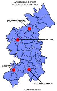
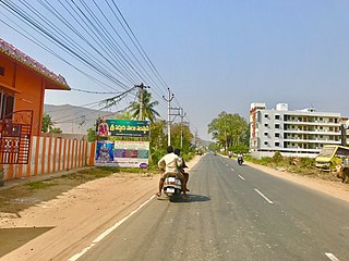
There are various modes of transportation available in Vizianagaram and its Neighbourhoods. It includes auto rickshaws, bicycles to mass transit systems - such as buses, trains and flights.

