Lake Alexandrina is a coastal freshwater lake located between the Fleurieu and Kangaroo Island and Murray and Mallee regions of South Australia, about 100 kilometres (62 mi) south-east of Adelaide. The lake adjoins the smaller Lake Albert and a coastal lagoon called The Coorong to its southeast, before draining into the Great Australian Bight via a short, narrow opening known as Murray Mouth.

Lake Albert, also known by its Ngarrindjeri name, Yarli, is a notionally fresh water lake near the mouth of the Murray River in South Australia. It is filled by water flowing in from the larger Lake Alexandrina at its mouth near Narrung. It is separated on the south by the Narrung Peninsula from the salt-water Coorong. The only major town on the lake is Meningie. Lakes Alexandrina and Albert are together known as the Lower Lakes.
Koraleigh is a small village in the west of the Riverina region of New South Wales, Australia. The village is on the Murray River and in Murray River Council local government area. Koraleigh is 6 kilometres (3.7 mi) northeast of Nyah, Victoria and 15 kilometres (9.3 mi) south of Tooleybuc.

The Palmer River is a river located in Far North Queensland, Australia. The area surrounding the river was the site of a gold rush in the late 19th century which started in 1873.
Maude is a village on the north bank of the Murrumbidgee River in New South Wales, Australia. It is in between Hay and Balranald in Hay Shire. It is located 55 kilometres downstream from Hay and 25 kilometres upstream from the junction of the Lachlan River with the Murrumbidgee. At the 2006 census, Maude had a population of 161 people. Maude consists of a General Store, hotel, post office and caravan park. The town is surrounded by market gardens supplied with water from Maude Weir, a popular spot for anglers, looking for yellow belly, redfin and Murray cod.
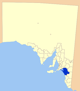
Coorong District Council is a local government area in South Australia located between the River Murray and the Limestone Coast region. The district cover mostly rural areas with small townships, as well as part of the Coorong National Park.

The Shire of Swan Hill was a local government area in north-western Victoria, Australia, along the Murray River. The shire covered an area of 6,550 square kilometres (2,529.0 sq mi), and existed from 1893 until 1995. From 1939 onwards, Swan Hill itself was managed by a separate entity; the City of Swan Hill. After a large-scale statewide amalgamation program by the Victorian Government in 1994–1995, they were reunited under the Rural City of Swan Hill.

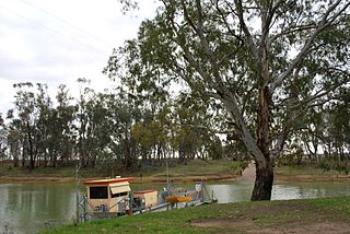
Narrung is a town and locality in the Australian state of South Australia. It is situated at the northern extent of the Narrung Peninsula, which separates The Coorong from Lake Albert adjacent to The Narrows which separates Lake Albert from the larger Lake Alexandrina. The area of Narrung includes the Aboriginal (Ngarrindjeri) community of Raukkan.
Narrung may refer to the following places in Australia:
Speewa is a rural locality in the Riverina District of New South Wales, Australia near the Murray River in Murray River Council local government area.

The Buffalo River Dene Nation is a Dene First Nations band government in Saskatchewan, Canada. The band's main community, Dillon, is located on the western shore of Peter Pond Lake at the mouth of the Dillon River, and is accessed by Highway 925 from Highway 155.
Albert was an electoral district of the House of Assembly in South Australia, spanning its time as both a colony and a state. It was created in 1875, taking much territory from adjacent Victoria, merged with Victoria in 1902 as Victoria and Albert, separated again in 1915, and abolished in 1970.
Salt Lagoon Islands Conservation Park is a protected area covering two islands and some adjoining waters in Salt Lagoon at the south east extent of Lake Alexandrina in South Australia about 14 kilometres south-west of Narrung.
Poltalloch is a locality in the Australian state of South Australia located on land between the water bodies of Lake Alexandrina and Lake Albert about 87 kilometres south-east of the state capital of Adelaide.

The County of Russell is one of the 49 cadastral counties of South Australia. It was proclaimed in 1842 by Governor George Grey and named for Lord John Russell, who was involved with the early development of the (British) South Australian colony when he was Secretary of State for War and the Colonies. It covers a portion of the state bounded to the west by the eastern half of Lake Alexandrina and the section of the Murray River extending to Bowhill in the north and bounded to the south by the coastline adjoining the Coorong coastal lagoon and fully surrounds Lake Albert which is excluded from its extent. This includes the north western quarter of the contemporary local government area of Coorong District Council.

Loveday Bay is an inlet in the Australian state of South Australia located at the south-eastern end of Lake Alexandrina on the west coast of the Narrung Peninsula.
The Jarildekald (Yarilde) are an indigenous Australian people of South Australia originating on the eastern side of Lake Alexandrina and the Murray River.
Meningie West is a locality in the Australian state of South Australia located in the state’s south-east about 99 kilometres (62 mi) south-east of the state capital of Adelaide and about 50 kilometres (31 mi) south-west of the municipal seat in Tailem Bend.
Nurrang Peninsula is a peninsula in the Australian state of South Australia located at the south east end of Lake Alexandrina. It is bounded by Lake Alexandrina to the west, by Lake Albert to the north and to the east, and by the Coorong to the south. While the name appears to have been in use since the 19th century and by all levels of government in South Australia, the name was not listed in the state government's official list of placenames until January 2020. Its extent is within the localities of Meningie West and Narrung.