
Toledo is a city located on the Yaquina River and along U.S. Route 20 in Lincoln County, in the U.S. state of Oregon. The population was 3,465 at the 2010 census. The city was a 2009 All-America City Award finalist.
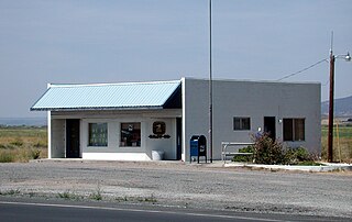
Riley is an unincorporated community in Harney County, Oregon, United States, located at the crossroads of U.S. Highway 395 and U.S. Highway 20, milepost 104, about 28 miles (45 km) west of Burns, the seat of Harney County. The elevation of Riley is 4,226 feet (1,288 m). The town presently consists entirely of two service establishments with attached apartments: a post office, and a general store with gas pump and garage service. It exists to serve the rural farming and ranching community that surrounds it, and highway travelers.
Alpine is an unincorporated rural community and census-designated place in Benton County, Oregon, United States. It is west of Monroe off Oregon Route 99W. As of the 2010 Census, the population was 171.

Copperfield is a former town in Baker County, in the U.S. state of Oregon. It is on the west bank of the Snake River and the north bank of Pine Creek, downstream of a feature of the Snake River known as The Oxbow. Copperfield Park, managed by Idaho Power, occupies the former town site. The Geographic Names Information System also lists Copperfield as a variant name for Oxbow, Oregon.

Seal Rock is an unincorporated coastal community in Lincoln County, Oregon, United States, between Newport and Waldport on U.S. Route 101.

Camp Adair was a United States Army division training facility established north of Corvallis, Oregon, operating from 1942 to 1946. During its peak period of use, the camp was home to approximately 40,000 persons — enough to have constituted the second largest city in the state of Oregon. The camp was largely scrapped as government surplus following termination of World War II, with a portion of the site reconstituted as "Adair Air Force Station" in 1957.

Chitwood is an unincorporated community in Lincoln County, Oregon, United States. Chitwood lies on U.S. Route 20 between Toledo to the west and Eddyville to the east. The Yaquina River flows through Chitwood.
Eddyville is an unincorporated community in Lincoln County, in the U.S. state of Oregon. Eddyville's unofficial estimated population as of 2014 was about 400 to 500.
Illahe is an unincorporated community and the site of a former post office in Curry County, Oregon, United States. Located along the Rogue River about 8 miles (13 km) upriver from Agness, the area was home to Takelma Indians, then to white and Karok settlers, before becoming part of a designated wilderness. In the 21st century, it is a stopping place for hikers, boaters, and other visitors. The area has a riverside lodge and a nearby campground, both named Illahe.

Marial is an unincorporated community and the site of a former post office in Curry County, Oregon, United States. Located along the Rogue River about 48 miles (77 km) from its mouth on the Pacific Ocean, the area was home to Takelma Indians, then to white and Karok settlers, before becoming part of a designated wilderness. Buildings preserved at the Rogue River Ranch pioneer farm complex, listed on the National Register of Historic Places, represent the former center of Marial. Nearby are the Tucker Flat Campground and a riverside lodge named Marial.
Placer is an unincorporated community in Josephine County, Oregon, United States, on Grave Creek a few miles east of Interstate 5. Established during the local gold mining boom, it is considered a ghost town.
Thomas Egenton Hogg (1828–1898) was a master in the Confederate States Navy who participated in raids on Union ships during the American Civil War. He was captured and sentenced to death, but was eventually released from prison, after which he became a businessman and railroad promoter in the U.S. state of Oregon. He worked to build the Oregon Pacific Railroad, though his dream to create a transcontinental railroad with its western terminus on the Oregon Coast was never realized.
John Sellwood was a pioneer Episcopal minister who settled in the U.S. state of Oregon on a 321-acre (130 ha) donation land claim on the east bank of the Willamette River upstream from Portland.
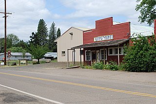
Harlan is an unincorporated community in Lincoln County, Oregon, United States, about 30 miles west of Corvallis. It is located in a valley of the Central Oregon Coast Range in the Siuslaw National Forest. The community's economy was once based on logging and sawmills. Cattle ranching is another mainstay of the local economy.
Burnt Woods is an unincorporated community in Lincoln County, Oregon, United States. It is located about 16 miles (26 km) west of Philomath on U.S. Route 20 in the Central Oregon Coast Range near the Tumtum River.
The Episcopal Church of the Good Samaritan is a multigenerational Episcopal faith community in Corvallis, Oregon. Originally located in the historic building on Madison and 7th, the church now holds services from its 1962 location on the corner of Harrison and 35th.

Peoria is an unincorporated community and census-designated place (CDP) in Linn County, Oregon, United States. It is on the right bank of the Willamette River at river mile 141 between Eugene and Corvallis. Lacking stores and services, it is a cluster of houses plus a county park along Peoria Road, about 8 miles (13 km) south of Oregon Route 34 and 12 miles (19 km) north of Harrisburg. As of the 2010 census, the population was 94.
Thomas is a ghost town in Linn County, in the U.S. state of Oregon.
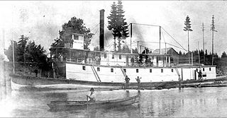
Three Sisters was a sternwheel-driven steamboat that operated on the Willamette River from 1886 to 1896. The steamer was built as an extreme shallow-draft vessel, to permit it to reach points on the upper Willamette river such as Corvallis, Harrisburg and Eugene, Oregon during summer months when water levels in the river were generally low. The vessel was also known for having been washed up on a county road in Oregon during a flood in 1890.
Suntex is the name of an unincorporated community in Harney County, in the U.S. state of Oregon. It was established with the placement of a post office in the valley of Silver Creek west of Burns and north of U.S. Route 20.


