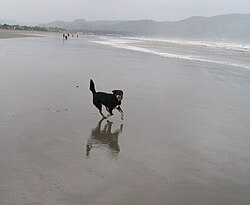
Agate Beach, Oregon | |
---|---|
Coordinates: 44°40′38″N124°03′42″W / 44.67722°N 124.06167°W Coordinates: 44°40′38″N124°03′42″W / 44.67722°N 124.06167°W | |
Country | United States |
State | Oregon |
County | Lincoln |
Elevation | 157 ft (48 m) |
Time zone | UTC-8 (PST) |
• Summer (DST) | UTC-7 (PDT) |
Coordinates and elevation from United States Geological Survey [1] |
Agate Beach is an unincorporated community in Lincoln County, Oregon, United States. [1] Agate Beach is named for the agates that are found on the beaches of the Pacific Ocean between Newport and Yaquina Head. Agate Beach post office was established in 1912 and closed in 1971. [2]
Historically, the area's most famous citizen is Composer Ernest Bloch, who spent his later years in the community. [3] The 1914 Ernest Bloch House is on the National Register of Historic Places and was once owned by the son of Asahel Bush and his family. [4]
In June 2012 a 165-ton floating dock dislodged from the March 2011 Japanese tsunami washed up ashore, [5] creating a popular tourist attraction as well as a panic to remove potential invasive species. [6]
Cannon Beach is a city in Clatsop County, Oregon, United States. Its population was 1,690 at the 2010 census. It is a popular coastal Oregon tourist destination, famous for Haystack Rock, a 235 ft (72 m) sea stack that juts out along the coast. In 2013, National Geographic listed it as "one of the world’s 100 most beautiful places."
Ernest Bloch was a Swiss-born American composer. Bloch was a preeminent artist in his day, and left a lasting legacy. He is recognized as one of the greatest Swiss composers in history. As well as producing musical scores, Bloch had an academic career that culminated in his recognition as Professor Emeritus at the University of California, Berkeley in 1952.
Governor Tom McCall Waterfront Park is a 36.59-acre (148,100 m2) park located in downtown Portland, Oregon, along the Willamette River. After the 1974 removal of Harbor Drive, a major milestone in the freeway removal movement, the park was opened to the public in 1978. The park covers 13 tax lots and is owned by the City of Portland. The park was renamed in 1984 to honor Tom McCall, the Oregon governor who pledged his support for the beautification of the west bank of the Willamette River—harkening back to the City Beautiful plans at the turn of the century which envisioned parks and greenways along the river. The park is bordered by RiverPlace to the south, the Steel Bridge to the north, Naito Parkway to the west, and Willamette River to the east. In October 2012, Waterfront Park was voted one of America's ten greatest public spaces by the American Planning Association.
Goshen is an unincorporated community in Lane County, Oregon, United States. It is located at the junction of Oregon Route 58, Oregon Route 99, and Interstate 5.
Agness is an unincorporated community in Curry County, Oregon, United States. It is near the confluence of two Wild and Scenic rivers—the Lower Rogue and the Illinois. Agness post office was established October 16, 1897. It was named after Agnes, the daughter of the first postmaster, and subsequently misspelled. The Agness area is popular for fishing and hiking. Agness is in the Rogue River–Siskiyou National Forest and was threatened by the Biscuit Fire in 2002.
Arock is an unincorporated community in Malheur County, Oregon, United States. It is part of the Ontario, OR–ID Micropolitan Statistical Area. Arock is along Arock Road, 3 miles (5 km) north of U.S. Route 95 between Jordan Valley and Rome. Jordan Creek flows near Arock and joins the Owyhee River just west of Arock.
Lewis Ankeny McArthur, known as "Tam" McArthur, was an executive for Pacific Power and Light Company. He was also the secretary for the Oregon Geographic Board for many years and the author of Oregon Geographic Names. His book, now in its seventh edition, is a comprehensive source of information on the origins and history of Oregon place names. It is a standard reference book in libraries throughout Oregon and the Pacific Northwest. Tam McArthur Rim in the Cascade Mountains is named in his honor.
Buxton is an unincorporated community in Washington County, Oregon, United States, near Oregon Route 47.
Wolf Creek is an unincorporated community in Josephine County, Oregon, United States, just off Interstate 5.
Walden is an unincorporated community in Lane County, Oregon, United States. It is about 3 miles (5 km) southeast of Cottage Grove, near the confluence of the Row River and Mosby Creek.
Tonquin is an unincorporated locale in Washington County, Oregon, United States.
Brighton is an unincorporated community in Tillamook County, Oregon, United States. It is about 3 kilometres (2 mi) southwest of Wheeler on U.S. Route 101 next to Nehalem Bay, across the bay from Nehalem Bay State Park.
Verboort is an unincorporated community in Washington County, Oregon, United States. It is located approximately two miles northeast of Forest Grove, one mile east of Oregon Route 47 in the Tualatin Valley. The community is part of the Forest Grove Rural Fire Protection District.
Tierra del Mar is an unincorporated community in Tillamook County, Oregon, United States, located on the Oregon Coast, about 25 miles (40 km) south of Tillamook and 4 miles (6.4 km) north of Pacific City and Cape Kiwanda, along Sandlake Road, west of U.S. Route 101.
Airlie is an unincorporated community in Polk County, Oregon, United States.
Oretown is an unincorporated community in Tillamook County, Oregon, United States. It is along U.S. Route 101 about 4 miles (6 km) north of Neskowin and south of Nestucca Bay.
Hobsonville is an unincorporated community in Tillamook County, Oregon, United States. Although it is considered a ghost town, it is still classified as a populated place by the United States Geological Survey (USGS). Hobsonville is on the east shore of Tillamook Bay, about 2 miles south of Garibaldi via U.S. Route 101 or about a mile from Garibaldi across Miami Cove.
Tallman is a ghost town in Linn County, in the U.S. state of Oregon. It is located northwest of Lebanon.
La Center was a small stern-wheel steamboat that operated from 1912 to 1931, mostly on the Lewis and Lake rivers in southwest Washington, on a route to and from Portland, Oregon along the lower Columbia and lower Willamette rivers.
Swan Island is located on the Willamette River about 4.5 miles (7.2 km) downriver from downtown Portland, Oregon, United States. Although presently connected to the Willamette's east bank, it existed as a river island under natural conditions.