Chitwood, Oregon | |
|---|---|
 | |
 Chitwood  Chitwood | |
| Coordinates: 44°39′17″N123°49′21″W / 44.65472°N 123.82250°W | |
| Country | United States |
| State | Oregon |
| County | Lincoln |
| Elevation | 141 ft (43 m) |
| Time zone | UTC-8 (PST) |
| • Summer (DST) | UTC-7 (PDT) |
| Coordinates and elevation from United States Geological Survey [1] | |
Chitwood is an unincorporated community in Lincoln County, Oregon, United States. [1] Chitwood lies on U.S. Route 20 between Toledo to the west and Eddyville to the east. [2] The Yaquina River flows through Chitwood. [2]
Historically, Chitwood was a station on the railway line between Corvallis and Toledo. It was named for Joshua Chitwood, who lived nearby during construction of the railway, 1881–85. [3] The line was originally known as the Yaquina Route of the Oregon Pacific Railroad, linking the former port city of Yaquina to Corvallis and Albany. [4] After the Oregon Pacific failed financially, fell into receivership, and went through 17 years of financial and legal complications, in 1907 it became a branch line of the Southern Pacific. [5]
The post office in Chitwood opened in 1887 and closed in 1945. [3]
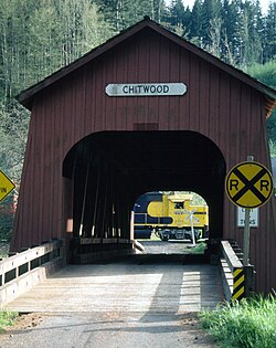
Lincoln County built Chitwood Bridge, a covered bridge, at Chitwood in 1926. Scheduled for demolition, it was instead improved in 1984 through a federally funded restoration project. The Howe truss bridge is 96 feet (29 m) long. [6]
