National Park of the Gulf of Orosei and Gennargentu

Last updated
Parco Nazionale del Golfo di Orosei e del Gennargentu
Gusana.jpg
Gusana Lake in the park
Italy provincial location map 2016.svg
Red pog.svg
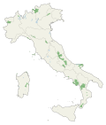
Gennargentu
Location of Gennargentu National Park
Location Sardegna
Nearest city Nuoro
Coordinates 39°59′23″N9°19′29″E / 39.98972°N 9.32472°E / 39.98972; 9.32472
Area730.00 km2 (281.85 sq mi)
Established1998
Governing bodyMinistero dell'Ambiente
www.parcogennargentu.it/index.htm

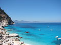
The Gennargentu National Park (also National Park of the Bay of Orosei and Gennargentu; Italian : Parco Nazionale del Golfo di Orosei e del Gennargentu) is a national park on the east coast of Sardinia. [1]

Contents

Wildlife in the park includes the Felis lybica sarda (also known as Sardinian wildcat), the mouflon, the marten, the weasel, the edible dormouse, the garden dormouse, the Sardinian fox, the griffon vulture, the golden eagle, the Bonelli's eagle, the peregrine falcon, the great spotted woodpecker, the butterfly Corsican swallowtail. [2] Marine mammals include the Mediterranean monk seal, the fin whale, [3] [4] sperm whale, [5] and various smaller whales and dolphins. [6]

The park lies in the provinces of Nuoro and Ogliastra. [1]

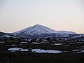
The highest mountain in Sardinia, Punta La Marmora, in the Gennargentu mountain range is within the boundaries of the National Park.

See also

Related Research Articles

<span class="mw-page-title-main">Sardinia</span> Island in the Mediterranean and region of Italy

Sardinia is the second-largest island in the Mediterranean Sea, after Sicily, and one of the twenty regions of Italy. It is located west of the Italian Peninsula, north of Tunisia and 16.45 km south of the French island of Corsica.

<span class="mw-page-title-main">Gallura</span>

Gallura is a region in North-Eastern Sardinia, Italy.

<span class="mw-page-title-main">Cagliari</span> Largest city in Sardinia, Italy

Cagliari is an Italian municipality and the capital and largest city of the island of Sardinia, an autonomous region of Italy. It has about 155,000 inhabitants, while its metropolitan city has about 420,000 inhabitants. According to Eurostat, the population of the functional urban area, the commuting zone of Cagliari, rises to 476,975. Cagliari is the 26th largest city in Italy and the largest city on the island of Sardinia.

Alghero is a city of about 45,000 inhabitants in the Italian province of Sassari in the north west of the island of Sardinia, next to the Mediterranean Sea. The city's name comes from Aleguerium, which is a mediaeval Latin word meaning "stagnation of algae".

<span class="mw-page-title-main">Gennargentu</span> Mountain in Italy

Gennargentu is a large massif in central-southern Sardinia, Italy, encompassing the provinces of Nuoro and Ogliastra. It includes the highest peaks on the island, such as Punta La Marmora, Monte Spada, Punta Erbas Virdes, Bruncu Spina and Punta Paulinu.

Cala Gonone is an Italian seaside town and a civil parish (frazione) of the municipality (comune) of Dorgali, Province of Nuoro, in the region of Sardinia. In 2007 it had 1,279 inhabitants.

<span class="mw-page-title-main">Province of Nuoro</span> Province of Italy

The province of Nuoro is a province in the autonomous island region of Sardinia, Italy. Its capital is the city of Nuoro.

<span class="mw-page-title-main">Tuscan Archipelago</span> Chain of islands between the Ligurian Sea and Tyrrhenian Sea

The Tuscan Archipelago is a chain of islands between the Ligurian Sea and Tyrrhenian Sea, west of Tuscany, Italy.

<span class="mw-page-title-main">Asinara</span> Italian island

Asinara is an Italian island of 52 km2 (20 sq mi) in area. The name is Italian for "donkey-inhabited", but it is thought to derive from the Latin "sinuaria", and meaning sinus-shaped. The island is virtually uninhabited. The census of population of 2001 lists one man. The island is located off the north-western tip of Sardinia, and is mountainous in geography with steep, rocky coasts. Because fresh water is scarce, trees are sparse and low scrub is the predominant vegetation. Part of the national parks system of Italy, the island was recently converted to a wildlife and marine preserve. It is home to a population of wild albino donkeys from which the island may take its name.

<span class="mw-page-title-main">Dorgali</span> Comune in Sardinia, Italy

Dorgali is a comune (municipality) in the Province of Nuoro in the Italian region Sardinia, located about 230 kilometres (140 mi) northeast of Cagliari and about 38 kilometres (24 mi) east of Nuoro in the Seaside Supramonte mountain area.

<span class="mw-page-title-main">Orosei</span> Comune in Sardinia, Italy

Orosei is a comune (municipality) in the Province of Nuoro in the Italian region Sardinia, located about 140 kilometres (87 mi) northeast of Cagliari and about 30 kilometres (19 mi) east of Nuoro.

Tiana, Tìana in Sardinian language, is a comune (municipality) in the Province of Nuoro in the Italian region Sardinia, located in a valley on the slopes of Gennargentu mountain in the Ollolai Barbagia, about 150 kilometres (93 mi) north of Cagliari and about 50 kilometres (31 mi) southwest of Nuoro. As of 31 December 2004, it had a population of 547 and an area of 19.3 square kilometres (7.5 sq mi).

<span class="mw-page-title-main">Supramonte</span> Mountain range located in central-eastern Sardinia, Italy

The Supramonte is a mountain range located in central-eastern Sardinia, Italy. It lies northeast of the Gennargentu massif, traveling eastwards until it reaches the Tyrrhenian Sea at the Gulf of Orosei. It has an area of about 35,000 hectares, encompassing most of the territories of the comuni (municipalities) of Baunei, Dorgali, Oliena, Orgosolo and Urzulei. The populated areas of these comuni lie at the borders of the Supramonte, which, for the most part, is a largely uninhabited area of sharp limestone cliffs and deep, lush canyons.

<span class="mw-page-title-main">Mount Limbara</span> Mountain in Italy

Mount Limbara is a rocky granitic massif in northeastern Sardinia, Italy. It is located in the geographical and historical region of Gallura.

<span class="mw-page-title-main">Fauna of Italy</span> Native animals of Italy

The fauna of Italy comprises all the animal species inhabiting the territory of the Italian Republic and its surrounding waters. Italy has the highest level of faunal biodiversity in Europe, with over 57,000 species recorded, representing more than a third of all European fauna. This is due to various factors. The Italian peninsula is in the centre of the Mediterranean Sea, forming a corridor between central Europe and North Africa, and it has 8,000 km (5,000 mi) of coastline. Italy also receives species from the Balkans, Eurasia, and the Middle East. Italy's varied geological structure, including the Alps and the Apennines, Central Italian woodlands, and Southern Italian Garigue and Maquis shrubland, also contribute to high climate and habitat diversity.

<span class="mw-page-title-main">Tourism in Sardinia</span> Place

Sardinia is the second-largest island in the Mediterranean Sea and an autonomous region of Italy. Tourism in Sardinia is one of the fastest growing sectors of the regional economy. The island attracts more than a million tourists from both Italy, from the rest of Europe, and, to a lesser degree, from the rest of the world. According to statistics, tourist arrivals in 2016 were 2.9 million people.

<span class="mw-page-title-main">Selvaggio Blu (Sardinia)</span>

The Selvaggio Blu is a trekking route in the territory of the district of Baunei (Sardinia). It was conceived in 1987 by Mario Verin, and Peppino Cicalò (architect), President of the Nuoro section of the Italian Alpine Club. The itinerary extends for over 40 kilometers from the touristic port of Santa Maria Navarrese (Baunei) to the beach of Cala Sisine (Baunei). It takes on average 4 days to complete.

<span class="mw-page-title-main">Path of 100 Towers (Sardinia)</span> Trekking route along the coastline of Sardinia in Italy

The Cammino 100 Torri is a multi-day trekking route that begins and ends in Cagliari (Sardinia). The path is named after the 105 historical coastal towers along the route.

<span class="mw-page-title-main">Bruncu Spina</span> Mountain in Sardinia, Italy

Bruncu Spina, with its 1,829 meters is the second highest peak in Sardinia after Punta La Marmora. It is located in the Gennargentu massif, in the province of Nuoro, in the administrative territory of the municipalities of Villagrande Strisaili and Desulo. The territorial portion in the head of the municipality of Villagrande Strisaili was granted in perpetual emphyteusis to the municipality of Fonni.

References

  1. 1 2 Ryan, David (4 May 2015). "Sardinia: An island of mad dogs and playboys" . The Independent. Archived from the original on 2022-06-18. Retrieved 21 January 2016.
  2. Szabo, Julius (22 March 2013). "Gennargentu National Park - see the wildlife of Sardinia". Visititaly.info. Retrieved 21 January 2016.
  3. Sardegna, avvistate 5 balenottere al largo di Cala Gonone /Video
  4. Muggianu N.. 2012. A Cala Gonone tornano i giganti dei mari
  5. Brennan C..2010. Nuotare tra balene e foche
  6. "Gonone santuario dei cetacei". Archived from the original on 2016-05-06. Retrieved 2016-04-22.