National Register of Historic Places listings in Scott County, Minnesota

Last updated

Location of Scott County in Minnesota Map of Minnesota highlighting Scott County.svg
Location of Scott County in Minnesota

This is a list of the National Register of Historic Places listings in Scott County, Minnesota. It is intended to be a complete list of the properties and districts on the National Register of Historic Places in Scott County, Minnesota, United States. The locations of National Register properties and districts for which the latitude and longitude coordinates are included below, may be seen in an online map.

Contents

There are 19 properties and districts listed on the National Register in the county. A supplementary list includes four additional sites that were formerly on the National Register.


    This National Park Service list is complete through NPS recent listings posted December 15, 2023. [1]

Current listings

Map all coordinates using: OpenStreetMap
[2] Name on the Register [3] ImageDate listed [4] Location City or townDescription
1 Abraham Bisson House
Abraham Bisson House Abraham Bisson House 2015.jpg
Abraham Bisson House
April 17, 1980
(#80002164)
20150 County Rd. 57
44°39′28″N93°42′30″W / 44.657666°N 93.70821°W / 44.657666; -93.70821 (Abraham Bisson House)
Jordan vicinity1884 house notable for its local sandstone masonry and association with the now-vanished town of St. Lawrence. [5]
2 Church of St. Wenceslaus
Church of St. Wenceslaus Church & School of St Wenceslaus.jpg
Church of St. Wenceslaus
February 19, 1982
(#82003035)
215–227 E. Main St.
44°32′39″N93°34′27″W / 44.544144°N 93.574223°W / 44.544144; -93.574223 (Church of St. Wenceslaus)
New Prague Religious and educational hub of a large Catholic Czech immigrant community, featuring a 1907 church, 1908 rectory, and 1914 parochial school. [6]
3 Julius A. Coller House
Julius A. Coller House Julius A. Coller House.jpg
Julius A. Coller House
April 17, 1980
(#80002168)
434 S. Lewis St.
44°47′41″N93°31′29″W / 44.794839°N 93.524704°W / 44.794839; -93.524704 (Julius A. Coller House)
Shakopee 1887 house of a significant community leader who served 16 years as a state senator. Also recognized as one of the best-preserved Scott County residences of its era. [7]
4 Early Shakopee Houses
Early Shakopee Houses Early Shakopee Houses.jpg
Early Shakopee Houses
April 17, 1980
(#80002169)
411 and 419 E. 2nd Ave.
44°47′54″N93°31′18″W / 44.798369°N 93.521706°W / 44.798369; -93.521706 (Early Shakopee Houses)
Shakopee Two adjacent houses built circa 1865, well-preserved examples of Shakopee's early residences. [8]
5 Episcopal Church of the Transfiguration
Episcopal Church of the Transfiguration Belle Plaine Transfiguration 2.JPG
Episcopal Church of the Transfiguration
April 17, 1980
(#80002159)
201 N. Walnut St.
44°37′28″N93°45′48″W / 44.624532°N 93.763426°W / 44.624532; -93.763426 (Episcopal Church of the Transfiguration)
Belle Plaine Unusual 1869 Stick style church. [9]
6 Foss and Wells House
Foss and Wells House Foss & Wells House.jpg
Foss and Wells House
April 17, 1980
(#80002161)
613 S. Broadway St.
44°39′23″N93°37′36″W / 44.656492°N 93.626723°W / 44.656492; -93.626723 (Foss and Wells House)
Jordan Shared 1858 house of two families who co-owned one of Jordan's key gristmills. Also noted for its sandstone masonry and Italianate architecture. [10]
7 Holmes Street Bridge
Holmes Street Bridge Holmes St Bridge.jpg
Holmes Street Bridge
July 6, 2010
(#10000414)
Holmes St. over the Minnesota River
44°48′01″N93°31′38″W / 44.800278°N 93.527222°W / 44.800278; -93.527222 (Holmes Street Bridge)
Shakopee Rare Minnesota example of a deck truss bridge, built in 1927 by the Minneapolis Steel & Machinery Company. [11]
8 Hooper-Bowler-Hillstrom House
Hooper-Bowler-Hillstrom House Hooper-Bowler-Hillstrom House.jpg
Hooper-Bowler-Hillstrom House
April 17, 1980
(#80002160)
410 N. Cedar St.
44°37′36″N93°45′56″W / 44.626575°N 93.765534°W / 44.626575; -93.765534 (Hooper-Bowler-Hillstrom House)
Belle Plaine Circa-1871 house significant as Scott County's best preserved 19th-century frame house and for its successive ownership by two prominent local businessmen. [12] Now a house museum. [13]
9 Inyan Ceyaka Otonwe
Inyan Ceyaka Otonwe Address restricted.PNG
Inyan Ceyaka Otonwe
February 12, 1999
(#99000191)
Carver Rapids unit of Minnesota Valley State Recreation Area [14]
Louisville Township Precolumbian mounds and site of a post-contact Wahpeton Dakota village led by notable chief Mazomani. [15]
10 Jordan Brewery Ruins
Jordan Brewery Ruins Jordan Brewery Ruins.jpg
Jordan Brewery Ruins
April 17, 1980
(#80002162)
415 S. Broadway St.
44°39′48″N93°37′32″W / 44.663434°N 93.625681°W / 44.663434; -93.625681 (Jordan Brewery Ruins)
Jordan Prominent remains of a brewery complex active 1861–1948, one of the leading businesses that made Jordan into an early industrial center. [16]
11 Jordan Historic District
Jordan Historic District Jordan Historic District.jpg
Jordan Historic District
April 17, 1980
(#80002163)
Water St. and S. Broadway St.
44°39′55″N93°37′34″W / 44.665276°N 93.626062°W / 44.665276; -93.626062 (Jordan Historic District)
Jordan Scott County's best-preserved 19th-century business district, with 14 contributing properties mostly dating to Jordan's peak as a commercial center 1865–1880. [17] [18]
12 Wencl Kajer Farmstead
Wencl Kajer Farmstead Kajer, Wencl, Farmstead2.JPG
Wencl Kajer Farmstead
April 17, 1980
(#80002166)
County Highway 2
44°34′30″N93°23′33″W / 44.574955°N 93.392455°W / 44.574955; -93.392455 (Wencl Kajer Farmstead)
New Market Township Hilltop dairy farm established in 1907, a highly visible representative of local agricultural development, with a distinctive 1918 round barn and a 1920 brick farmhouse. [19]
13 Maka Yusota
Maka Yusota Maka Yusota.jpg
Maka Yusota
January 16, 2003
(#02001703)
Address restricted
44°46′14″N93°23′52″W / 44.770556°N 93.397778°W / 44.770556; -93.397778 (Maka Yusota)
Savage vicinityA sacred spring important in Dakota history and culture. [20]
14 Mudbaden Sulphur Springs Company
Mudbaden Sulphur Springs Company Mudbaden Sulphur Springs Company.jpg
Mudbaden Sulphur Springs Company
April 17, 1980
(#80002165)
17706 Valley View Dr.
44°41′35″N93°37′01″W / 44.693015°N 93.616825°W / 44.693015; -93.616825 (Mudbaden Sulphur Springs Company)
Jordan vicinity1915 spa building of a popular health resort in operation 1890s–1947, serving patients and vacationers attracted to its sulfur-rich mud baths. [21]
15 New Market Hotel and Store
New Market Hotel and Store New Market Hotel and Store.JPG
New Market Hotel and Store
April 17, 1980
(#80002167)
441 Main St.
44°34′24″N93°21′07″W / 44.573228°N 93.351922°W / 44.573228; -93.351922 (New Market Hotel and Store)
Elko New Market Well-preserved example—built 1897—of Scott County towns' late-19th-century commercial buildings, and the only surviving example from New Market. [22]
16 St. Mary's Church of the Purification
St. Mary's Church of the Purification 1209ND7K 5309.jpg
St. Mary's Church of the Purification
April 17, 1980
(#80002173)
15850 Marystown Rd.
44°43′13″N93°32′31″W / 44.720353°N 93.541822°W / 44.720353; -93.541822 (St. Mary's Church of the Purification)
Marystown 1882 Romanesque Revival church and associated buildings constructed 1893–1921, representative of the Catholic church properties around which many German American settlements grew in rural Scott County. [23]
17 Herman Schroeder House and Livery
Herman Schroeder House and Livery HermanSchroederHouseShakopeeMN.jpg
Herman Schroeder House and Livery
January 19, 2023
(#100008547)
717–719 Bluff Ave. E.
44°48′03″N93°31′05″W / 44.8009°N 93.518°W / 44.8009; -93.518 (Herman Schroeder House and Livery)
Shakopee Ornate 1880 house and outbuilding of Herman Schroeder (1854–1922), longtime owner of Shakopee's most successful brickyard and an influential civic leader. [24]
18 Shakopee Historic District
Shakopee Historic District Shakopeemounds.JPG
Shakopee Historic District
April 11, 1972
(#72000682)
1801–2187 County Highway 101
44°48′11″N93°29′48″W / 44.803161°N 93.496667°W / 44.803161; -93.496667 (Shakopee Historic District)
Shakopee District encompassing ancient habitation sites and mounds, a contact-era Dakota village, and pioneer-era buildings and a ferry landing. [25]
19 Strunk-Nyssen House
Strunk-Nyssen House Strunk-Nyssen House.jpg
Strunk-Nyssen House
April 17, 1980
(#80002174)
11120 Chaparral Ave.
44°47′20″N93°33′26″W / 44.788785°N 93.55736°W / 44.788785; -93.55736 (Strunk-Nyssen House)
Shakopee vicinityCirca-1856 house enlarged circa 1880, significant as the successive home of notable local brewers Herman H. Strunk and Hubert Nyssen and as an example of 19th-century vernacular architecture. [26]

Former listings

[2] Name on the RegisterImageDate listedDate removedLocationCity or townDescription
1 Bridge No. L3040 November 6, 1989
(#89001829)
September 20, 2007County Road 51, North of Minnesota State Highway 19
Belle Plaine Unusually early stone arch road bridge, built 1878. [27] Demolished in 2006. [28]
2 Merchants Hotel April 17, 1980
(#80002171)
September 25, 1987211 E. 2nd St.
Shakopee 1865 hotel. [29] Fell into disrepair and demolished in 1987. [30]
3 Reis Block April 17, 1980
(#80002172)
May 15, 19871st and Holmes Sts.
Shakopee 1883 Queen Anne commercial building with second-floor auditorium. Demolished by owner in 1986. [31]
4 Roehl-Lenzmeier House April 17, 1980
(#82003032)
June 11, 200310th Ave. W.
Shakopee vicinityCirca-1860 stone farmhouse of a notable homesteader. [32] Demolished in 2002. [28]

See also

Related Research Articles

<span class="mw-page-title-main">National Register of Historic Places listings in Dakota County, Minnesota</span>

This is a list of the National Register of Historic Places listings in Dakota County, Minnesota. It is intended to be a complete list of the properties and districts on the National Register of Historic Places in Dakota County, Minnesota, United States. Dakota County is located in the southeastern part of the U.S. state of Minnesota, bounded on the northeast side by the Upper Mississippi River and on the northwest by the Minnesota River. The locations of National Register properties and districts for which the latitude and longitude coordinates are included below, may be seen in an online map.

<span class="mw-page-title-main">Early Shakopee Houses</span> Historic houses in Minnesota, United States

The Early Shakopee Houses are a pair of houses located at 411 and 419 East 2nd Avenue, Shakopee, Minnesota, United States. They are listed on the National Register of Historic Places.

<span class="mw-page-title-main">Strunk–Nyssen House</span> Historic house in Minnesota, United States

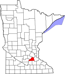
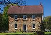
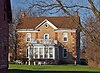
The Strunk–Nyssen House is a historic property in Jackson Township, Minnesota, United States, just outside the city of Shakopee. The original wing of the house was built around 1856 for Herman H. Strunk, who established the area's first brewery on the site. The brewery went by several names over the course of its existence, but is commonly referred to as the Shakopee Brewery. The residence was enlarged around 1880 by Hubert and Mary Nyssen, who used the second floor as a boarding house. The Nyssens continued operating the brewery until 1920.

<span class="mw-page-title-main">National Register of Historic Places listings in Rice County, Minnesota</span>

This is a list of the National Register of Historic Places listings in Rice County, Minnesota. It is intended to be a complete list of the properties and districts on the National Register of Historic Places in Rice County, Minnesota, United States. The locations of National Register properties and districts for which the latitude and longitude coordinates are included below, may be seen in an online map.

<span class="mw-page-title-main">National Register of Historic Places listings in Carver County, Minnesota</span>

This is a list of the National Register of Historic Places listings in Carver County, Minnesota. It is intended to be a complete list of the properties and districts on the National Register of Historic Places in Carver County, Minnesota, United States. The locations of National Register properties and districts for which the latitude and longitude coordinates are included below, may be seen in an online map.

<span class="mw-page-title-main">National Register of Historic Places listings in Goodhue County, Minnesota</span>

This is a list of the National Register of Historic Places listings in Goodhue County, Minnesota. It is intended to be a complete list of the properties and districts on the National Register of Historic Places in Goodhue County, Minnesota, United States. The locations of National Register properties and districts for which the latitude and longitude coordinates are included below, may be seen in an online map.

<span class="mw-page-title-main">National Register of Historic Places listings in Stearns County, Minnesota</span>

This is a list of the National Register of Historic Places listings in Stearns County, Minnesota. It is intended to be a complete list of the properties and districts on the National Register of Historic Places in Stearns County, Minnesota, United States. The locations of National Register properties and districts for which the latitude and longitude coordinates are included below, may be seen in an online map.

<span class="mw-page-title-main">National Register of Historic Places listings in Blue Earth County, Minnesota</span>

This is a list of the National Register of Historic Places listings in Blue Earth County, Minnesota. It is intended to be a complete list of the properties and districts on the National Register of Historic Places in Blue Earth County, Minnesota, United States. The locations of National Register properties and districts for which the latitude and longitude coordinates are included below, may be seen in an online map.

<span class="mw-page-title-main">National Register of Historic Places listings in Morrison County, Minnesota</span>

This is a list of the National Register of Historic Places listings in Morrison County, Minnesota. It is intended to be a complete list of the properties and districts on the National Register of Historic Places in Morrison County, Minnesota, United States. The locations of National Register properties and districts for which the latitude and longitude coordinates are included below, may be seen in an online map.

<span class="mw-page-title-main">National Register of Historic Places listings in Olmsted County, Minnesota</span>

This is a list of the National Register of Historic Places listings in Olmsted County, Minnesota. It is intended to be a complete list of the properties and districts on the National Register of Historic Places in Olmsted County, Minnesota, United States. The locations of National Register properties and districts for which the latitude and longitude coordinates are included below, may be seen in an online map.

<span class="mw-page-title-main">National Register of Historic Places listings in Chisago County, Minnesota</span>

This is a list of the National Register of Historic Places listings in Chisago County, Minnesota. It is intended to be a complete list of the properties and districts on the National Register of Historic Places in Chisago County, Minnesota, United States. The locations of National Register properties and districts for which the latitude and longitude coordinates are included below, may be seen in an online map.

<span class="mw-page-title-main">National Register of Historic Places listings in Le Sueur County, Minnesota</span>

This is a list of the National Register of Historic Places listings in Le Sueur County, Minnesota. It is intended to be a complete list of the properties and districts on the National Register of Historic Places in Le Sueur County, Minnesota, United States. The locations of National Register properties and districts for which the latitude and longitude coordinates are included below, may be seen in an online map.

<span class="mw-page-title-main">National Register of Historic Places listings in Washington County, Minnesota</span>

This is a list of the National Register of Historic Places listings in Washington County, Minnesota. It is intended to be a complete list of the properties and districts on the National Register of Historic Places in Washington County, Minnesota, United States. The locations of National Register properties and districts for which the latitude and longitude coordinates are included below, may be seen in an online map.

<span class="mw-page-title-main">National Register of Historic Places listings in Wright County, Minnesota</span>

This is a list of the National Register of Historic Places listings in Wright County, Minnesota. It is intended to be a complete list of the properties and districts on the National Register of Historic Places in Wright County, Minnesota, United States. The locations of National Register properties and districts for which the latitude and longitude coordinates are included below, may be seen in an online map.

<span class="mw-page-title-main">National Register of Historic Places listings in Douglas County, Minnesota</span>

This is a list of the National Register of Historic Places listings in Douglas County, Minnesota. It is intended to be a complete list of the properties and districts on the National Register of Historic Places in Douglas County, Minnesota, United States. The locations of National Register properties and districts for which the latitude and longitude coordinates are included below, may be seen in an online map.

<span class="mw-page-title-main">National Register of Historic Places listings in Pipestone County, Minnesota</span>

This is a list of the National Register of Historic Places listings in Pipestone County, Minnesota. It is intended to be a complete list of the properties and districts on the National Register of Historic Places in Pipestone County, Minnesota, United States. The locations of National Register properties and districts for which the latitude and longitude coordinates are included below, may be seen in an online map.

<span class="mw-page-title-main">National Register of Historic Places listings in Faribault County, Minnesota</span>

This is a list of the National Register of Historic Places listings in Faribault County, Minnesota. This is intended to be a complete list of the properties and districts on the National Register of Historic Places in Faribault County, Minnesota, United States. The locations of National Register properties and districts for which the latitude and longitude coordinates are included below, may be seen in an online map.

<span class="mw-page-title-main">National Register of Historic Places listings in Waseca County, Minnesota</span>

This is a list of the National Register of Historic Places listings in Waseca County, Minnesota. It is intended to be a complete list of the properties and districts on the National Register of Historic Places in Waseca County, Minnesota, United States. The locations of National Register properties and districts for which the latitude and longitude coordinates are included below, may be seen in an online map.

<span class="mw-page-title-main">National Register of Historic Places listings in Isanti County, Minnesota</span>

This is a list of the National Register of Historic Places listings in Isanti County, Minnesota. It is intended to be a complete list of the properties and districts on the National Register of Historic Places in Isanti County, Minnesota, United States. The locations of National Register properties and districts for which the latitude and longitude coordinates are included below, may be seen in an online map.

References

  1. National Park Service, United States Department of the Interior, "National Register of Historic Places: Weekly List Actions", retrieved December 15, 2023.
  2. 1 2 Numbers represent an alphabetical ordering by significant words. Various colorings, defined here, differentiate National Historic Landmarks and historic districts from other NRHP buildings, structures, sites or objects.
  3. "National Register Information System". National Register of Historic Places . National Park Service. April 24, 2008.
  4. The eight-digit number below each date is the number assigned to each location in the National Register Information System database, which can be viewed by clicking the number.
  5. Bloomberg, Britta (July 1979). "National Register of Historic Places Registration Form: Bisson House". National Park Service. Retrieved 2013-04-14.
  6. Bloomberg, Britta (August 1980). "National Register of Historic Places Registration Form: St. Wenceslaus Church Complex". National Park Service. Retrieved 2013-04-14.
  7. Bloomberg, Britta (July 1979). "National Register of Historic Places Registration Form: Coller House". National Park Service. Retrieved 2013-04-14.
  8. Bloomberg, Britta (July 1979). "National Register of Historic Places Registration Form: Early Shakopee Houses". National Park Service. Retrieved 2013-04-14.
  9. Bloomberg, Britta (July 1979). "National Register of Historic Places Registration Form: Episcopal Church of the Transfiguration". National Park Service. Retrieved 2013-04-14.
  10. Bloomberg, Britta (July 1979). "National Register of Historic Places Registration Form: Foss and Wells House". National Park Service. Retrieved 2013-04-14.
  11. Long, Christine; Bob Frame; Heather Goodson (2010-01-21). "National Register of Historic Places Registration Form: Holmes Street Bridge". National Park Service. Retrieved 2013-05-06.
  12. Bloomberg, Britta (July 1979). "National Register of Historic Places Registration Form: Hooper - Bowler - Hillstrom House". National Park Service. Retrieved 2013-05-07.
  13. "Hooper-Bowler-Hillstrom House". City of Belle Plaine. Retrieved 2013-05-06.
  14. Location derived from Gardner, Denis P. (2004). Minnesota Treasures: Stories Behind the State's Historic Places. St. Paul, Minn.: Minnesota Historical Society Press. ISBN   0-87351-471-8. NRIS lists site as "address restricted".
  15. Nord, Mary Ann (2003). The National Register of Historic Places in Minnesota . Minnesota Historical Society. ISBN   0-87351-448-3.
  16. Bloomberg, Britta (July 1979). "National Register of Historic Places Registration Form: Jordan Brewery Ruins". National Park Service. Retrieved 2013-05-07.
  17. Bloomberg, Britta (July 1979). "National Register of Historic Places Registration Form: Jordan Historic District". National Park Service. Retrieved 2013-05-07.
  18. "Jordan Historic District". Minnesota National Register Properties Database. Minnesota Historical Society. 2009. Retrieved 2013-05-07.
  19. Bloomberg, Britta (July 1979). "National Register of Historic Places Registration Form: Kajer Farmstead". National Park Service. Retrieved 2013-05-07.
  20. "Registration: Recent Additions to the National Register of Historic Places" (PDF). Minnesota Preservation Planner. Minnesota Historical Society. Spring 2003. Archived from the original (PDF) on 2008-11-20.
  21. Bloomberg, Britta (July 1979). "National Register of Historic Places Registration Form: Mudbaden Sulphur Springs Company". National Park Service. Retrieved 2013-05-09.
  22. Bloomberg, Britta (July 1979). "National Register of Historic Places Registration Form: New Market Hotel and Store". National Park Service. Retrieved 2013-05-09.
  23. Bloomberg, Britta (July 1979). "National Register of Historic Places Registration Form: St. Mary's Church of the Purification - Church Complex". National Park Service. Retrieved 2013-05-09.
  24. Que, Sr., Erin; Saleh Miller (2022-07-06). National Register of Historic Places Registration Form: Schroeder, Herman, House and Livery (PDF). Minnesota State Historic Preservation Office. Retrieved 2023-11-19.
  25. Grossman, John (1970-03-10). National Register of Historic Places Inventory – Nomination Form: Shakopee Historic District. National Park Service. Retrieved 2023-12-19.
  26. Bloomberg, Britta (July 1979). "National Register of Historic Places Registration Form: Strunk-Nyssen House". National Park Service. Retrieved 2013-05-09.
  27. Hess, Jeffrey A. "Bridge No. L-3040: Historic Significance". Minnesota's Historic Bridges. Minnesota Historical Society. Archived from the original on 2013-05-06. Retrieved 2013-05-09.
  28. 1 2 "Changes to the National Register of Historic Places in Minnesota, 2003-2010". Minnesota State Historic Preservation Office. 2011-02-01. Retrieved 2013-03-01.
  29. "Merchants Hotel (removed)". Minnesota National Register Properties Database. Minnesota Historical Society. 2009. Retrieved 2013-05-09.
  30. El-Hai, Jack (2000). Lost Minnesota: Stories of Vanished Places. Minneapolis: University of Minnesota Press. p. 104. ISBN   0816635153.
  31. El-Hai, Jack (2000). Lost Minnesota: Stories of Vanished Places. Minneapolis: University of Minnesota Press. p. 108. ISBN   0816635153.
  32. "Roehl-Lenzmeier House (removed)". Minnesota National Register Properties Database. Minnesota Historical Society. 2009. Retrieved 2013-05-09.