Kansk is a town in Krasnoyarsk Krai, Russia, located on both banks of the Kan River. Population: 94,226 (2010 Census); 103,000 (2002 Census); 109,607 (1989 Soviet census).
Popigay is a rural locality in Taymyrsky Dolgano-Nenetsky District of Krasnoyarsk Krai, Russia. It is known for the Popigay River and Popigay crater. Population: 334 (2010 Census); 358 (2002 Census);
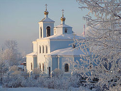
Borodino is a town in Krasnoyarsk Krai, Russia, located 186 kilometers (116 mi) northeast of Krasnoyarsk, the administrative center of the krai. Population: 17,416 (2010 Census); 19,181 (2002 Census); 18,426 (1989 Soviet census).

Nazarovo is a town in Krasnoyarsk Krai, Russia, located on the left bank of the Chulym River, 239 kilometers (149 mi) west of Krasnoyarsk. Population: 52,817 (2010 Census); 56,539 (2002 Census); 64,350 (1989 Soviet census).

Sukhobuzimsky District is an administrative and municipal district (raion), one of the forty-three in Krasnoyarsk Krai, Russia. It is located in the south of the krai. The area of the district is 5,612 square kilometers (2,167 sq mi). Its administrative center is the rural locality of Sukhobuzimskoye. Population: 20,537 (2010 Census); 23,445 (2002 Census); 25,460 (1989 Soviet census). The population of Sukhobuzimskoye accounts for 21.2% of the district's total population.

Achinsky District is an administrative and municipal district (raion), one of the forty-three in Krasnoyarsk Krai, Russia. It is located in the southwest of the krai and borders with Bolsheuluysky District in the north, Kozulsky District in the east, Nazarovsky District in the south, and with Bogotolsky District in the west. The area of the district is 2,534 square kilometers (978 sq mi). Its administrative center is the city of Achinsk. Population: 15,870 (2010 Census); 14,904 ; 15,597 (1989 Soviet census).

Bogotolsky District is an administrative and municipal district (raion), one of the forty-three in Krasnoyarsk Krai, Russia. It is located in the southwest of the krai and borders with Tyukhtetsky District in the north, Bolsheuluysky District in the southeast, Achinsky District in the east, Nazarovsky and Sharypovsky Districts in the south, and with Kemerovo Oblast in the west. The area of the district is 2,924 square kilometers (1,129 sq mi). Its administrative center is the town of Bogotol. Population: 11,267 (2010 Census); 12,415 ; 14,978 (1989 Soviet census).

Kezhemsky District is an administrative and municipal district (raion), one of the forty-three in Krasnoyarsk Krai, Russia. It is located in the east of the krai and borders with Evenkiysky District in the north, Irkutsk Oblast in the east and south, and with Boguchansky District in the west. The area of the district is 34,541 square kilometers (13,336 sq mi). Its administrative center is the town of Kodinsk. Population: 22,072 (2010 Census); 24,997 (2002 Census); 31,233 (1989 Soviet census). The population of Kodinsk accounts for 67.2% of the district's total population.

Kozulsky District is an administrative and municipal district (raion), one of the forty-three in Krasnoyarsk Krai, Russia. It is located in the southwest of the krai and borders with Birilyussky District in the north, Yemelyanovsky District in the east, Balakhtinsky District in the south, and with Nazarovsky, Achinsky and Bolsheuluysky Districts in the west. The area of the district is 5,305 square kilometers (2,048 sq mi). Its administrative center is the urban locality of Kozulka. Population: 16,689 (2010 Census); 19,010 ; 22,076 (1989 Soviet census). The population of Kozulka accounts for 47.9% of the district's total population.

Novosyolovsky District is an administrative and municipal district (raion), one of the forty-three in Krasnoyarsk Krai, Russia. It is located in the southwest of the krai and borders with Balakhtinsky District in the north and east, Krasnoturansky District in the southeast, the Republic of Khakassia in the southwest and west, and with Uzhursky District in the northwest. The area of the district is 3,881 square kilometers (1,498 sq mi). Its administrative center is the rural locality of Novosyolovo. Population: 14,135 (2010 Census); 16,382 ; 17,358 (1989 Soviet census). The population of Novosyolovo accounts for 42.3% of the district's total population.

Sharypovsky District is an administrative and municipal district (raion), one of the forty-three districts in Krasnoyarsk Krai, Russia. It is located in the southwest of the krai and borders with Bogotolsky District in the north, Nazarovsky and Uzhursky Districts in the east, the Republic of Khakassia in the south and southwest, and with Kemerovo Oblast in the west and northwest. The area of the district is 3,751 square kilometers (1,448 sq mi). Its administrative center is the town of Sharypovo. Population: 15,109 (2010 Census); 17,775 (2002 Census); 16,259 (1989 Soviet census).

Shushensky District is an administrative and municipal district (raion), one of the forty-three in Krasnoyarsk Krai, Russia. It is located in the south of the krai and borders with Minusinsky District in the north, Karatuzsky District in the northeast, Yermakovsky District in the east and southeast, the Tuva Republic in the southwest, and with the Republic of Khakassia in the west. The area of the district is 10,140 square kilometers (3,920 sq mi). Its administrative center is the urban locality of Shushenskoye. Population: 33,216 (2010 Census); 36,891 ; 37,628 (1989 Soviet census). The population of Shushenskoye accounts for 52.7% of the district's total population.
Yeniseysky District is an administrative and municipal district (raion), one of the forty-three in Krasnoyarsk Krai, Russia. It is located in the west of the krai and borders with Turukhansky and Evenkiysky Districts in the north, Severo-Yeniseysky and Motyginsky Districts in the east, Kazachinsky District in the southeast, Pirovsky, Birilyussky, and Tyukhtetsky Districts in the southwest, Tomsk Oblast in the west, and with Khanty–Mansi Autonomous Okrug in the northwest. The area of the district is 106,300 square kilometers (41,000 sq mi). Its administrative center is the town of Yeniseysk. Population: 27,223 (2010 Census); 31,315 ; 30,477 (1989 Soviet census).

Bolshoy Uluy is a rural locality and the administrative center of Bolsheuluysky District, Krasnoyarsk Krai, Russia. Population: 3,340 (2010 Census); 3,417 (2002 Census); 4,003 (1989 Soviet census).

Kazachinskoye is a rural locality and the administrative center of Kazachinsky District, Krasnoyarsk Krai, Russia. Population: 3,864 (2010 Census); 4,050 (2002 Census); 4,876 (1989 Soviet census).

Karatuzskoye is a rural locality and the administrative center of Karatuzsky District, Krasnoyarsk Krai, Russia. Population: 7,456 (2010 Census); 8,025 (2002 Census); 8,864 (1989 Soviet census).

Shalinskoye is a rural locality and the administrative center of Mansky District, Krasnoyarsk Krai, Russia. Population: 3,932 (2010 Census); 4,264 (2002 Census); 5,115 (1989 Soviet census).
Novosyolovo is a rural locality and the administrative center of Novosyolovsky District, Krasnoyarsk Krai, Russia. Population: 5,980 (2010 Census); 6,350 (2002 Census); 6,595 (1989 Soviet census).
Partizanskoye is a rural locality and the administrative center of Partizansky District, Krasnoyarsk Krai, Russia. Population: 3,525 (2010 Census); 3,977 (2002 Census); 5,049 (1989 Soviet census).

Pirovskoye is a rural locality and the administrative center of Pirovsky District, Krasnoyarsk Krai, Russia. Population: 3,007 (2010 Census); 3,292 (2002 Census); 4,059 (1989 Soviet census).