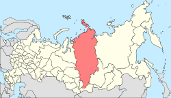
Uzhur is a town and the administrative center of Uzhursky District in Krasnoyarsk Krai, Russia, located approximately 300 kilometers (190 mi) from Krasnoyarsk between Kuznetsk Alatau and Solgon mountain ranges where the Chernavka River flows into the Uzhurka. Population: 16,093 (2010 Census); 17,252 (2002 Census); 28,376 (1989 Census).
Zelenogorsk is a closed town in Krasnoyarsk Krai, Russia, located on the left bank of the Kan River 180 kilometers (110 mi) above its confluence with the Yenisei River. It was formerly known as Krasnoyarsk-45 (Красноя́рск-45) and was involved in enriching uranium for the Soviet nuclear program. Population: 66,056 (2010 Census); 69,355 (2002 Census).

Sosnovoborsk is a town in Krasnoyarsk Krai, Russia, located on the right bank of the Yenisei River, 45 kilometers (28 mi) northeast of Krasnoyarsk. Population: 33,091 (2010 Census); 30,586 (2002 Census); 29,686 (1989 Census).

Kodinsk is a town and the administrative center of Kezhemsky District of Krasnoyarsk Krai, Russia, located on the Angara River, 735 kilometers (457 mi) north of Krasnoyarsk. Population: 14,830 (2010 Census); 14,746 (2002 Census); 14,050 (1989 Census).

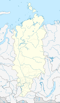
Sukhobuzimsky District is an administrative and municipal district (raion), one of the forty-three in Krasnoyarsk Krai, Russia. It is located in the south of the krai. The area of the district is 5,612 square kilometers (2,167 sq mi). Its administrative center is the rural locality of Sukhobuzimskoye. Population: 20,537 (2010 Census); 23,445 (2002 Census); 25,460 (1989 Census). The population of Sukhobuzimskoye accounts for 21.2% of the district's total population.

Yemelyanovsky District is an administrative and municipal district (raion), one of the forty-three in Krasnoyarsk Krai, Russia. It is located in the southern central part of the krai and borders with Bolshemurtinsky District in the north, Sukhobuzimsky District in the northeast, Beryozovsky District and the territory of the krai city of Krasnoyarsk in the east, Balakhtinsky District in the south, Kozulsky District in the west, and with Birilyussky District in the northwest. The area of the district is 7,441 square kilometers (2,873 sq mi). Its administrative center is the urban locality of Yemelyanovo. Population: 51,159 ; 50,998 (2010 Census); 45,656 ; 48,375 (1989 Census). The population of Yemelyanovo accounts for 23.6% of the district's total population.

Bogotolsky District is an administrative and municipal district (raion), one of the forty-three in Krasnoyarsk Krai, Russia. It is located in the southwest of the krai and borders with Tyukhtetsky District in the north, Bolsheuluysky District in the southeast, Achinsky District in the east, Nazarovsky and Sharypovsky Districts in the south, and with Kemerovo Oblast in the west. The area of the district is 2,924 square kilometers (1,129 sq mi). Its administrative center is the town of Bogotol. Population: 11,267 (2010 Census); 12,415 ; 14,978 (1989 Census).
Dzerzhinsky District is an administrative and municipal district (raion), one of the forty-three in Krasnoyarsk Krai, Russia. It is located in the southeast of the krai and borders with Taseyevsky District in the north, Abansky District in the east, Kansky District in the south, and with Sukhobuzimsky District in the west. The area of the district is 3,569 square kilometers (1,378 sq mi). Its administrative center is the rural locality of Dzerzhinskoye. Population: 14,552 (2010 Census); 17,028 ; 20,485 (1989 Census). The population of Dzerzhinskoye accounts for 50.7% of the district's total population.

Idrinsky District is an administrative and municipal district (raion), one of the forty-three in Krasnoyarsk Krai, Russia. It is located in the southwest of the krai and borders with Balakhtinsky District in the north, Kuraginsky District in the east and south, and with Krasnoturansky District in the west. The area of the district is 6,115 square kilometers (2,361 sq mi). Its administrative center is the rural locality of Idrinskoye. Population: 12,472 (2010 Census); 15,399 ; 17,780 (1989 Census). The population of Idrinskoye accounts for 41.2% of the district's total population.

Irbeysky District is an administrative and municipal district (raion), one of the forty-three in Krasnoyarsk Krai, Russia. It is located in the southwest of the krai and borders with Kansky and Ilansky Districts in the north, Irkutsk Oblast in the east and south, Rybinsky District in the southwest, and with Sayansky District in the west. The area of the district is 10,921 square kilometers (4,217 sq mi). Its administrative center is the rural locality of Irbeyskoye. Population: 16,784 (2010 Census); 19,181 ; 21,572 (1989 Census). The population of Irbeyskoye accounts for 27.9% of the district's total population.

Kansky District is an administrative and municipal district (raion), one of the forty-three in Krasnoyarsk Krai, Russia. It is located in the southeast of the krai and borders with Dzerzhinsky District in the north, Abansky District in the northeast, Ilansky District in the east, Irbeysky District in the south, Rybinsky District in the southwest, and with Sukhobuzimsky District in the west. The area of the district is 4,321 square kilometers (1,668 sq mi). Its administrative center is the town of Kansk. Population: 27,281 (2010 Census); 28,667 ; 31,177 (1989 Census).

Kozulsky District is an administrative and municipal district (raion), one of the forty-three in Krasnoyarsk Krai, Russia. It is located in the southwest of the krai and borders with Birilyussky District in the north, Yemelyanovsky District in the east, Balakhtinsky District in the south, and with Nazarovsky, Achinsky and Bolsheuluysky Districts in the west. The area of the district is 5,305 square kilometers (2,048 sq mi). Its administrative center is the urban locality of Kozulka. Population: 16,689 (2010 Census); 19,010 ; 22,076 (1989 Census). The population of Kozulka accounts for 47.9% of the district's total population.
Nazarovsky District is an administrative and municipal district (raion), one of the forty-three in Krasnoyarsk Krai, Russia. It is located in the southwest of the krai and borders with Achinsky District in the north, Kozulsky District in the east, Balakhtinsky District in the southeast, Uzhursky District in the south, Sharypovsky District in the west, and with Bogotolsky District in the northwest. The area of the district is 4,230 square kilometers (1,630 sq mi). Its administrative center is the town of Nazarovo. Population: 23,547 (2010 Census); 24,265 ; 21,720 (1989 Census).

Partizansky District is an administrative and municipal district (raion), one of the forty-three in Krasnoyarsk Krai, Russia. It is located in the south of the krai and borders with Uyarsky District in the north, Rybinsky District in the northeast, Sayansky District in the east, Kuraginsky District in the south, and with Mansky District in the west. The area of the district is 4,959 square kilometers (1,915 sq mi). Its administrative center is the rural locality of Partizanskoye. Population: 10,254 (2010 Census); 12,437 ; 15,412 (1989 Census). The population of Partizanskoye accounts for 34.4% of the district's total population.

Rybinsky District is an administrative and municipal district (raion), one of the forty-three in Krasnoyarsk Krai, Russia. It is located in the southeast of the krai and borders with Kansky District in the northeast, Irbeysky District in the southeast, Sayansky District in the south, Partizansky District in the southwest, Uyarsky District in the west, and with Sukhobuzimsky District in the northwest. The area of the district is 3,506 square kilometers (1,354 sq mi). Its administrative center is the town of Zaozyorny. Population: 31,954 (2010 Census); 21,186 ; 23,294 (1989 Census). The population of Zaozyorny accounts for 33.4% of the district's total population.
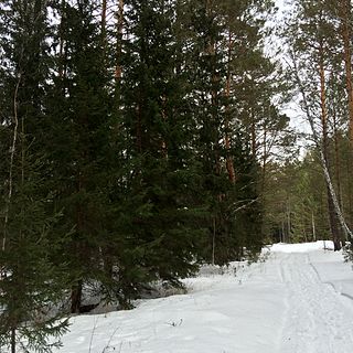
Yeniseysky District is an administrative and municipal district (raion), one of the forty-three in Krasnoyarsk Krai, Russia. It is located in the west of the krai and borders with Turukhansky and Evenkiysky Districts in the north, Severo-Yeniseysky and Motyginsky Districts in the east, Kazachinsky District in the southeast, Pirovsky, Birilyussky, and Tyukhtetsky Districts in the southwest, Tomsk Oblast in the west, and with Khanty–Mansi Autonomous Okrug in the northwest. The area of the district is 106,300 square kilometers (41,000 sq mi). Its administrative center is the town of Yeniseysk. Population: 27,223 (2010 Census); 31,315 ; 30,477 (1989 Census).

Kedrovy is an urban locality in Yemelyanovsky District of Krasnoyarsk Krai, Russia, located 50 kilometers (31 mi) from Krasnoyarsk, the administrative center of the krai. Population: 4,692 (2010 Census); 5,223.

Ilansky is a town and the administrative center of Ilansky District of Krasnoyarsk Krai, Russia, located on the Ilanka River 279 kilometers (173 mi) east of Krasnoyarsk. Population: 16,111 (2010 Census); 17,073 (2002 Census); 18,409 (1989 Census).

Uyar is a town and the administrative center of Uyarsky District of Krasnoyarsk Krai, Russia, located on the Uyarka River 132 kilometers (82 mi) east of Krasnoyarsk. Population: 12,665 (2010 Census); 13,807 (2002 Census); 17,040 (1989 Census).
Novosyolovo is a rural locality and the administrative center of Novosyolovsky District, Krasnoyarsk Krai, Russia. Population: 5,980 (2010 Census); 6,350 (2002 Census); 6,595 (1989 Census).