New Columbia, Pennsylvania | |
|---|---|
| Newky | |
 | |
 Interactive map of New Columbia, Pennsylvania | |
| Country | United States |
| State | Pennsylvania |
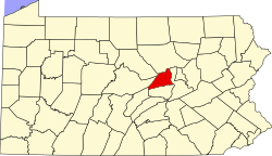
| County | Union |
| Township | White Deer |
| Area | |
• Total | 1.93 sq mi (5.00 km2) |
| • Land | 1.93 sq mi (5.00 km2) |
| • Water | 0 sq mi (0.00 km2) |
| Population | |
• Total | 1,024 |
| • Density | 530.8/sq mi (204.94/km2) |
| Time zone | UTC-5 (Eastern (EST)) |
| • Summer (DST) | UTC-4 (EDT) |
| Zip Code | 17856 |
| Area code | 570 |
| FIPS code | 42-53432 |
New Columbia is a census-designated place [3] located in White Deer Township, Union County in the state of Pennsylvania. The community is located in eastern Union County along U.S. Route 15, very near to the West Branch Susquehanna River. As of the 2010 census [4] the population was 1,013 residents.