Winfield, Pennsylvania

Last updated

Winfield, Pennsylvania
Pennsylvania Route 304 in Winfield.JPG
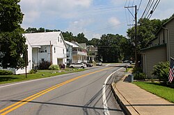
Pennsylvania Route 304 eastbound in Winfield
Country United States
State Pennsylvania
County Union
Township Union
Population
 (2010)
  Total900
Time zone UTC-5 (Eastern (EST))
  Summer (DST) UTC-4 (EDT)
ZIP code
17889 [1]
Area code(s) 272 and 570

Winfield is a census-designated place [2] located in Union Township, Union County in the state of Pennsylvania. The community is located in eastern Union County at the intersection of Pennsylvania Route 304 and U.S. Route 15, which is located along the shores of the West Branch Susquehanna River. As of the 2010 census [3] the population was 900 residents.

Contents

Notable people

See also

Related Research Articles

<span class="mw-page-title-main">Union County, Pennsylvania</span> County in Pennsylvania, United States

Union County is a county in the Commonwealth of Pennsylvania. As of the 2020 census, the population was 42,681. Its county seat is Lewisburg. The county was created on March 22, 1813, from part of Northumberland County. Its name is an allusion to the federal Union. Mifflinburg was established by legislation as the first county seat until it was moved to New Berlin in 1815. Lewisburg became county seat in 1855 and has remained so since. Union County comprises the Lewisburg, PA Micropolitan Statistical Area, which is also included in the Bloomsburg-Berwick-Sunbury, PA Combined Statistical Area. The county is part of the Central Pennsylvania region of the state.

<span class="mw-page-title-main">West Conshohocken, Pennsylvania</span> Borough in Pennsylvania, United States

West Conshohocken is a borough in Montgomery County, Pennsylvania, United States. The population was 1,320 at the 2010 census.

<span class="mw-page-title-main">Kline Township, Schuylkill County, Pennsylvania</span> Township in Pennsylvania, United States

Kline Township is a township in Schuylkill County, Pennsylvania. The population was 1,473 at the 2020 census.

<span class="mw-page-title-main">Loganville, Pennsylvania</span> Borough in Pennsylvania, United States

Loganville is a borough in York County, Pennsylvania, United States. The population was 1,427 at the time of the 2020 census. It was founded in 1820 and named after Colonel Henry Logan. It is part of the York–Hanover metropolitan area.

<span class="mw-page-title-main">Winfield Township, Illinois</span> Township in Illinois, United States

Winfield Township is one of nine townships in DuPage County, Illinois, USA. As of the 2020 census, its population was 45,836 and it contained 16,445 housing units. It is the least populous of the DuPage County Townships.

<span class="mw-page-title-main">Mount Aetna, Pennsylvania</span> Census-designated place in Pennsylvania, United States

Mount Aetna is a census-designated place in Tulpehocken Township, Berks County, Pennsylvania, United States. It is located along Pennsylvania Route 501 near the border of Lebanon County. The community is named after the active volcano, Mount Etna, in Sicily. As of the 2010 census, the population was 354 residents.

<span class="mw-page-title-main">Plowville, Pennsylvania</span> Unincorporated area in Pennsylvania, U.S.

Plowville is an unincorporated area of Robeson Township, Berks County, Pennsylvania, United States. It is located on Pennsylvania Route 10, just east of Interstate 176. Its zip code is 19540 and the community is served by the Twin Valley School District. The most recognizable landmark is Plow Church.

<span class="mw-page-title-main">Malta, Pennsylvania</span> Unincorporated community in Pennsylvania, U.S.

Malta is an unincorporated community in Lower Mahanoy Township Northumberland County, Pennsylvania, United States. It is located in the USGS quadrangle of Millersburg and has an elevation of 541 feet (165 m) above sea level. It was formerly known as Vera Cruz.

Schubert is a census-designated place in northeastern Bethel Township, Berks County, Pennsylvania. It is located off PA Route 419 just north of its interchange with Interstate 78 on the southern flank of Blue Mountain.

<span class="mw-page-title-main">Atlas, Pennsylvania</span> Census-designated place in Pennsylvania, United States

Atlas is a census-designated place located in Mount Carmel Township, Northumberland County in the state of Pennsylvania. The community is located very close to the borough of Mount Carmel along Pennsylvania Route 61. As of the 2010 census the population was 809 residents.

Kapp Heights is a census-designated place located in Point Township, Northumberland County in the state of Pennsylvania. The community is located very close to the borough of Northumberland along Pennsylvania Route 147, near the confluence of the West Branch Susquehanna River and Susquehanna Rivers. As of the 2010 census the population was 863 residents.

<span class="mw-page-title-main">Montandon, Pennsylvania</span> Census-designated place in Pennsylvania, United States

Montandon is a census-designated place located in West Chillisquaque Township, Northumberland County in the state of Pennsylvania, United States. The community is located near the West Branch Susquehanna River at the intersections of Pennsylvania Routes 147 and 45, roughly halfway between the boroughs of Northumberland and Milton. As of the 2010 census the population was 903 residents.

<span class="mw-page-title-main">Tharptown, Pennsylvania</span> Census-designated place in Pennsylvania, United States

Tharptown, also known as Uniontown, is a census-designated place located in Coal Township, Northumberland County in the state of Pennsylvania. The community is located just to the north of the city of Shamokin along Pennsylvania Route 61. As of the 2020 census the population was 487 residents.

<span class="mw-page-title-main">Hegins, Pennsylvania</span> Census-designated place in Pennsylvania, United States

Hegins is a census-designated place located in Hegins Township, Schuylkill County in the state of Pennsylvania, United States. The community is located near the community of Valley View at the intersection of Pennsylvania Routes 25 and 125 and is approximately 50 miles northeast of Harrisburg. As of the 2018 the population was 850.

<span class="mw-page-title-main">Reinerton, Pennsylvania</span> Census-designated place in Pennsylvania, United States

Reinerton is a census-designated place located in Porter Township, Schuylkill County in the state of Pennsylvania, United States. Reinerton was part of the Reinerton-Orwin-Muir CDP at the 2000 census before splitting into three individual CDPs for the 2010 census. The other communities, along with Reinerton are Orwin and Muir. The community is located near the community of Muir along U.S. Route 209. As of the 2010 census, the population was 424 residents.

<span class="mw-page-title-main">Vicksburg, Union County, Pennsylvania</span> Census-designated place in Pennsylvania, United States

Vicksburg is a census-designated place located in Buffalo Township, Union County, Pennsylvania, United States. It is located between the boroughs of Mifflinburg and Lewisburg along Pennsylvania Route 45. As of the 2010 census the population was 261 residents.

<span class="mw-page-title-main">West Milton, Pennsylvania</span> Census-designated place in Pennsylvania, United States

West Milton is a census-designated place located in Kelly and White Deer Townships in Union County in the state of Pennsylvania. The community is located directly across the West Branch Susquehanna River from the borough of Milton which is located in Northumberland County, from which West Milton derived its name. West Milton is located along U.S. Route 15, a few miles south of the community of New Columbia. Between Milton and West Milton, in the river is Montgomery Island where Milton State Park is located. As of the 2010 census the population was 900 residents.

<span class="mw-page-title-main">Elrama, Pennsylvania</span> Census-designated place in Pennsylvania, United States

Elrama is a census-designated place located in Union Township, Washington County in the state of Pennsylvania. The community is located in the eastern tip of Union Township in Washington County, near the Monongahela River, along Pennsylvania Route 837. As of the 2020 census, the population was 285 residents.

<span class="mw-page-title-main">Dalmatia, Pennsylvania</span> Census-designated place in Pennsylvania, United States

Dalmatia is a census-designated place located in Lower Mahanoy Township, Northumberland County in the state of Pennsylvania. The community is located along Pennsylvania Route 147 in southwestern Northumberland County, along the Susquehanna River. As of the 2010 census the population was 488 residents.

Sheshequin is an unincorporated community in Bradford County, in the U.S. state of Pennsylvania.

References

  1. "Winfield PA ZIP Code". zipdatamaps.com. 2023. Retrieved June 27, 2023.
  2. [ dead link ]
  3. https://www.census.gov/# [ not specific enough to verify ]
  4. "Steve Kline Stats, Height, Weight, Position, Rookie Status & More".

40°54′33″N76°51′19″W / 40.90917°N 76.85528°W / 40.90917; -76.85528