Newbiggin, Furness

Last updated

Newbiggin
Village
Coast at Newbiggin - geograph.org.uk - 141744.jpg
Coast at Newbiggin
Location map United Kingdom South Lakeland.svg
Red pog.svg
Newbiggin
Location in the former South Lakeland district
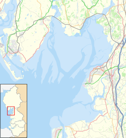
Location map United Kingdom Morecambe Bay.svg
Red pog.svg
Newbiggin
Location on Morecambe Bay
Cumbria UK location map.svg
Red pog.svg
Newbiggin
Location within Cumbria
OS grid reference SD267692
Civil parish
Unitary authority
Ceremonial county
Region
Country England
Sovereign state United Kingdom
Post town ULVERSTON
Postcode district LA12
Dialling code 01229
Police Cumbria
Fire Cumbria
Ambulance North West
UK Parliament
List of places
UK
England
Cumbria
54°06′50″N3°07′12″W / 54.114°N 3.120°W / 54.114; -3.120

Newbiggin is a village on the A5087 road, in the civil parish of Aldingham, [1] in Furness, in the unitary authority area of Westmorland and Furness, in the ceremonial county of Cumbria, England. Historically in Lancashire, nearby settlements include the large town of Barrow-in-Furness, the village of Aldingham and the hamlet of Roosebeck.

Related Research Articles

Newbiggin may refer to several places in England:

<span class="mw-page-title-main">Ainstable</span> Village and civil parish in Cumbria, England

Ainstable is a village and civil parish in the English county of Cumbria. Historically part of the traditional county of Cumberland, it is now in the unitary authority area of Westmorland and Furness.

<span class="mw-page-title-main">Aldingham</span> Human settlement in England

Aldingham is a village and civil parish in the Westmorland and Furness Unitary Authority of Cumbria, England. Historically in Lancashire, it is situated on the east coast of the Furness peninsula, facing into Morecambe Bay, and is about 8 miles (13 km) east of Barrow-in-Furness, and 6 miles (9.7 km) south of Ulverston. The parish includes the nearby villages of Baycliff, Dendron, Leece, Gleaston, Newbiggin, Roosebeck, Scales and a number of smaller hamlets. According to the 2001 census the parish had a population of 1,187, reducing to 1,105 at the 2011 Census.

<span class="mw-page-title-main">Ravenstonedale</span> Human settlement in England

Ravenstonedale is a village and large civil parish in Cumbria, on the watershed between the River Lune and River Eden. The village lies 4 miles (6 km) south west of Kirkby Stephen. The parish includes the village of Newbiggin-on-Lune and several smaller settlements including Bowderdale, Brownber, Greenside, Stennerskeugh, Wath and Weasdale. Large areas of moorland lie within the parish, extending 5 miles (8 km) south west of the village to the northern side of the Howgill Fells. The parish had a population of 570 in 2001, increasing to 594 at the 2011 Census.

<span class="mw-page-title-main">Dacre, Cumbria</span> Village and parish in the Lake District, England

Dacre is a small village, civil parish and electoral ward in the Lake District National Park in the Eden District of Cumbria, England, and historically in Cumberland. In the 2001 census, the parish, which includes Newbiggin and Stainton, had a population of 1,326, increasing to 1,438 at the 2011 Census.

<span class="mw-page-title-main">Gleaston</span> Human settlement in England

Gleaston is a village with a population of around 400 in the Furness area of South Cumbria, situated between the towns of Barrow-in-Furness, Dalton-in-Furness and Ulverston. Historically in Lancashire, the history of the village can be traced as far back as the mesolithic period and it was the centre of the manor of Muchland in the Middle Ages. Today it is largely a commuter village for the nearby towns, but its past is still visible in the remains of Gleaston Castle and Gleaston Water Mill, which is open as a tourist attraction.

<span class="mw-page-title-main">Leece</span> Human settlement in England

Leece is a village on the Furness peninsula in Cumbria, England, between the towns of Ulverston and Barrow-in-Furness.

<span class="mw-page-title-main">Muchland</span> Manor in Low Furness, Cumbria, England

Muchland is a medieval manor in Low Furness in the county of Cumbria in northern England. The manor was the seat of the Lords of Aldingham, and included at its peak the villages of Bardsea, Urswick, Scales, Stainton, Sunbrick, Baycliff, Gleaston, Aldingham, Dendron, Leece and Newbiggin. The area also features the historic remains of Gleaston Castle, Aldingham Castle, Gleaston Water Mill, the Druids' Temple at Birkrigg, plus many prehistoric remains around Urswick and Scales.

<span class="mw-page-title-main">Newbiggin, Dacre</span> Human settlement in England

Newbiggin is a small village in Cumbria, North West England. It is in the Dacre civil parish about 3 mi (4.8 km) west of Penrith. It lies at 750 ft (230 m) sheltered from the prevailing south-westerly wind by Flusco Pike, 150 ft (46 m) higher. It is described as a "non-nucleated village," lying for a mile along either side of the C3019 between the A66 and the B5288. There are at least six other villages in Cumbria with the same name, which is derived from the Old English ‘new biggin', or new house. Locally this village is referred to as the "Stainton Newbiggin," to distinguish it from the others.

<span class="mw-page-title-main">Blencow</span> Human settlement in England

Blencow or Blencowe is a small village near Penrith, Cumbria, England. It is divided by the River Petteril into Great Blencow to the south and Little Blencow to the north. Great Blencow is in the civil parish of Dacre while Little Blencow is within Greystoke parish.

<span class="mw-page-title-main">Dendron, Cumbria</span> Village in England

Dendron is a small village in South Cumbria, England. It is situated around three miles from the town of Barrow-in-Furness. The village was once just a collection of farms, but many of the old farm buildings have now been converted into houses for commuters working in Barrow, Ulverston and Dalton.

Scales is a small village in Westmorland and Furness, Cumbria, England. The town of Ulverston is around 3.5 miles south of the village. The name Scales comes from the Old Norse skali, with an Old English plural *Scalas, meaning huts. It is in the historic county of Lancashire.

<span class="mw-page-title-main">Allithwaite</span> Village in England

Allithwaite is a village in Cumbria, England, located roughly 1.2 miles (1.9 km) west of Grange-over-Sands. Within the boundaries of the historic county of Lancashire, Allithwaite, and the village of Cartmel situated to the north, are part of the civil parish of Lower Allithwaite. At the 2001 census, the parish had a population of 1,758, increasing to 1,831 at the 2011 Census.

<span class="mw-page-title-main">Gleaston Castle</span> 14th-century enclosure castle near Gleaston, England

Gleaston Castle is a medieval building in a valley about 1 kilometre (0.62 mi) north-east of the village of Gleaston. The village lies between the towns of Ulverston and Barrow-in-Furness in the Furness peninsula, Cumbria, England. Gleaston Castle has a quadrilateral plan, with a tower at each corner. The largest of these, the north-west tower, probably housed a hall.

<span class="mw-page-title-main">Newbiggin-on-Lune</span> Village in England

Newbiggin-on-Lune is a village in Cumbria, England. Historically in Westmorland it is about 4 miles (6.4 km) south west of Kirkby Stephen, and lies on the main A685 route from Brough to Tebay. Nearby to the north is located the Smardale Gill Viaduct on the dismantled former South Durham & Lancashire Union Railway between Tebay and Kirkby Stephen East railway station. To the south lies the Howgill Fells including Green Bell 1,985 feet.

<span class="mw-page-title-main">Baycliff</span> Seaside village in South Lakeland District of Cumbria, England

Baycliff is a seaside village in the Westmorland and Furness unitary authority area of Cumbria in England. Historically in Lancashire, it lies 3 miles (4.8 km) south of Ulverston, in the civil parish of Aldingham. At the centre is a village green, and many of its buildings date from the 17th and 18th centuries. The two public houses, the Farmer's Arms and the Fisherman's Arms, stand close to the green.

<span class="mw-page-title-main">Newbiggin, Kirkby Thore</span> Human settlement in England

Newbiggin is a village and civil parish near the larger village of Temple Sowerby, in the Eden District of the English county of Cumbria. In 2001 it had a population of 96. The population at the 2011 Census was less than 100 and data was included with Temple Sowerby.

Aldingham is a civil parish in the South Lakeland District of Cumbria, England. It contains 28 listed buildings that are recorded in the National Heritage List for England. Of these, one is listed at Grade I, the highest of the three grades, one is at Grade II*, the middle grade, and the others are at Grade II, the lowest grade. The parish contains villages, including Aldingham, Baycliff, Dendron, Leece, Gleaston, and Scales, and the surrounding countryside. The listed buildings include houses and associated structures, farmhouses and farm buildings, churches and items in a churchyard, a ruined castle, a Friends' burial ground, a former corn mill, two village halls, one originally a malt kiln, three follies, and four limekilns.

Roosebeck is a hamlet in the Unitary Authority of Westmorland and Furness, Cumbria, England, on the north west coast of Morecambe Bay. It is in the civil parish of Aldingham.

<span class="mw-page-title-main">Dalton Town with Newton</span> Human settlement in England

Dalton Town with Newton is a civil parish in Westmorland and Furness Unitary Authority, in the county of Cumbria, England. The parish includes the town of Dalton-in-Furness and the hamlet of Newton. In 2011 it had a population of 8,125. The parish touches Aldingham, Askam and Ireleth, Lindal and Marton and Urswick.

References

  1. "Your Parish". Aldingham Parish Council. Retrieved 26 June 2020.